Background
Moving object trajectories are rich sources of patterns about how people, vehicles, and objects move in space and time. Prior work has explored a range of trajectory patterns, from groups with similar behavior to chases, flocks, and periodic movements. However, most existing trajectory outlier detection methods operate on the entire dataset without considering the semantic meaning of where trajectories start and end, nor the temporal context of movement. Several methods prior to this work partition the space or compare trajectories globally, yielding spatial outliers that may be technically distant but not semantically informative with respect to typical routes between meaningful places. As a result, important insights tied to movement intent and temporal variation can be missed.
Problem / Research Question
The core question is how to uncover outliers that are semantically meaningful within the context of moving between specific regions, and how to incorporate time as a first-class dimension. The authors propose that a useful outlier concept should compare trajectories that move between the same regions of interest, identify standard (common) paths that connect those regions, and then detect trajectories that follow alternative or atypical routes. They further contend that time matters: the same regions may exhibit different standard paths or outliers across seasons, rush hours, or other temporal windows, so a spatio-temporal view is essential for actionable insight.
Innovation / Contribution
The main contribution is the introduction of semantic spatial and spatio-temporal outliers for moving object trajectories, together with an algorithm designed to discover them. Unlike global-distance or density-based outlier detectors, the method anchors analysis to region pairs (for example, a shopping center to the downtown area) and searches for the most frequent routes between those regions. Trajectories that diverge from these standard routes are labeled as semantic outliers, and the approach can reveal outliers that only appear in particular times (e.g., high season, peak hours). This semantic framing enables richer interpretations, such as identifying alternative but potentially efficient paths and uncovering previously unknown points of interest for transportation planning.
Methodology / Approach
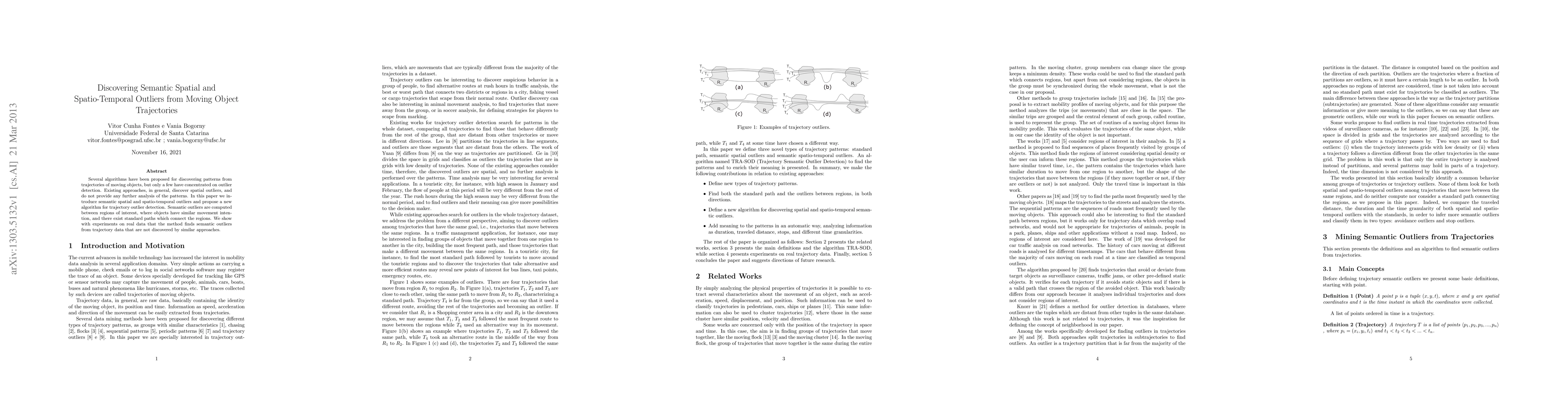
The approach begins by defining Regions of Interest (ROIs) and focusing on trajectories that move from region R1 to region R2. For each region pair, the method extracts the set of trajectories and analyzes their route shapes to identify a standard path or cluster of common movements. A trajectory is considered a semantic outlier if its route substantially deviates from this standard pattern, potentially in the middle of the journey or in its timing, reflecting a different but meaningful movement intention. Time is integrated by comparing trajectories within temporal windows or seasonal contexts, so that standard paths and outliers can shift over time. The paper emphasizes that semantic outliers reveal patterns not captured by spatial-only detectors, and provides intuitive examples where most trajectories share a common route while one trajectory takes a notably different course.
Experiments / Evaluation
The authors validate the approach with experiments on real trajectory data. They show that the proposed semantic outlier detector identifies outliers that remain undetected by competing methods that assess outliers at a global spatial level or rely solely on spatial proximity or density. The experimental narratives reference concrete scenarios (as illustrated in Figure 1) where several trajectories between the same region pair share a standard path while others diverge in meaningful ways, highlighting the method’s ability to uncover semantics and temporal variations in movement.
Key Results
Key results indicate that semantic spatial and spatio-temporal outliers provide richer, more interpretable insights than traditional outlier notions. The method can distinguish trajectories that merely wander far from the majority from those that depart from a standard, purposeful path between two regions, and it can capture how these patterns evolve over time. This leads to more informative patterns for decision-makers in transportation planning, tourism, and emergency routing.
Practical Applications
The technique is well aligned with real-world needs in traffic management, urban planning, and mobility services. By identifying standard routes and their semantic deviations between important regions, city planners can discover alternative networks worth analyzing, optimize routing for taxis or buses, plan emergency or redundancy routes, and detect shifts in movement that may signal new points of interest or changing urban dynamics.
Limitations & Considerations
Several considerations emerge. The effectiveness hinges on how regions of interest are defined and how fine-grained the ROIs are chosen; overly coarse or overly fine partitions can obscure true semantics. The method relies on robust temporal segmentation to capture seasonal or hourly patterns, which requires careful parameterization. Scalability to very large datasets or to networks with many region pairs may pose computational challenges, and the approach presumes accurate region labeling and trajectory sampling. Ground truth for semantic outliers is hard to obtain, making evaluation and cross-city generalization another area to scrutinize. Finally, integrating network topology and travel times could further strengthen the semantic interpretation but adds complexity.
Discussion 0