A new calibration technique called NOVA estimates distances to obstacles in outdoor environments for visually impaired people with an accuracy of <30cm and up to 60cm for other obstacles. It outperforms state-of-the-art methods by up to 5.3-14.6x.
Autonomous navigation by drones using onboard sensors, combined with deep learning and computer vision algorithms, is impacting a number of domains. We examine the use of drones to autonomously assist Visually Impaired People (VIPs) in navigating outdoor environments while avoiding obstacles. Here, we present NOVA, a robust calibration technique using depth maps to estimate absolute distances to obstacles in a campus environment. NOVA uses a dynamic-update method that can adapt to adversarial scenarios. We compare NOVA with SOTA depth map approaches, and with geometric and regression-based baseline models, for distance estimation to VIPs and other obstacles in diverse and dynamic conditions. We also provide exhaustive evaluations to validate the robustness and generalizability of our methods. NOVA predicts distances to VIP with an error <30cm and to different obstacles like cars and bicycles with a maximum of 60cm error, which are better than the baselines. NOVA also clearly out-performs SOTA depth map methods, by upto 5.3-14.6x.
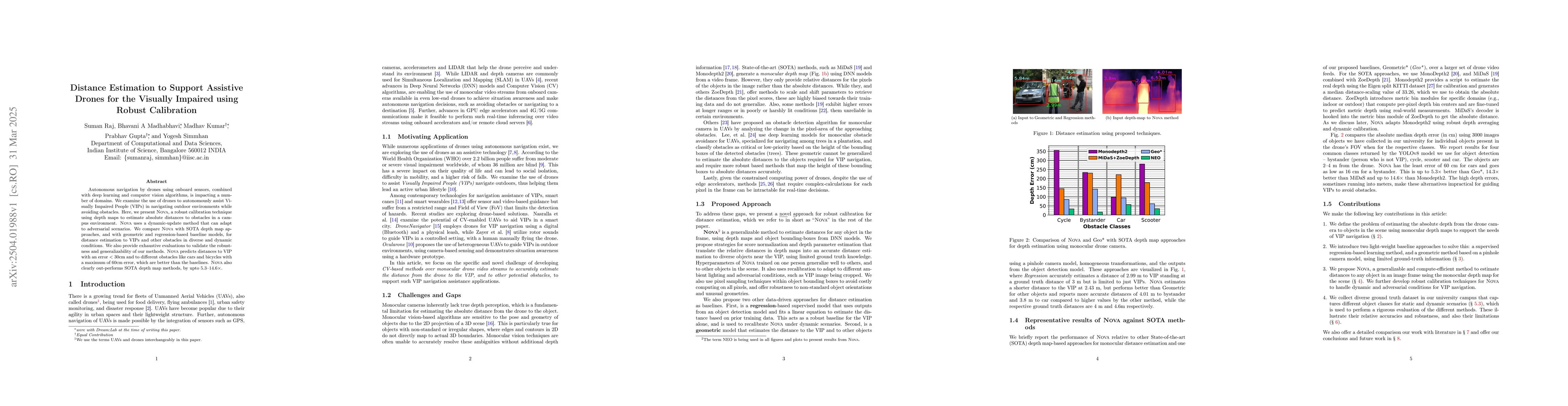
Generated Jun 10, 2025
The research presents NOVA, a robust calibration technique using depth maps for distance estimation to obstacles in outdoor environments, specifically designed for assisting visually impaired people (VIPs). NOVA employs a dynamic-update method adaptable to adversarial scenarios, and it is compared with state-of-the-art (SOTA) depth map approaches, geometric, and regression-based baseline models.
This research is significant as it aims to autonomously assist visually impaired individuals in navigating outdoor environments using drones, enhancing their mobility and independence by providing accurate distance estimations to obstacles.
The main technical contribution is the development of NOVA, a robust calibration technique using depth maps for distance estimation to obstacles, which dynamically updates and adapts to challenging scenarios.
NOVA distinguishes itself from existing research by focusing on robustness and adaptability in distance estimation for assistive drones targeting visually impaired individuals, outperforming current SOTA depth map methods significantly.
Current paper (gray), citations (green), references (blue)
Display is limited for performance on very large graphs.
Dionysia Danai Brilli, Evangelos Georgaras, Stefania Tsilivaki et al.
Avinash Agarwal, Saidarshan Bhagat, Padmaja Joshi et al.
Title | Authors | Year | Actions |
---|
Comments (0)