The research combines quantum-enhanced magnetic sensing with map-based geo-localization, utilizing a two-stage adaptive sensing protocol and Mahalanobis map-matching engine on high-resolution USGS magnetic anomaly data.
Distributed Quantum Magnetic Sensing for Infrastructure-free Geo-localization
Publication
Metrics
Quick Answers
What methodology did the authors use?
The research combines quantum-enhanced magnetic sensing with map-based geo-localization, utilizing a two-stage adaptive sensing protocol and Mahalanobis map-matching engine on high-resolution USGS magnetic anomaly data. More in Methodology →
What are the key results?
Achieved nT-level magnetic field estimation accuracy — Sub-kilometer median localization error under realistic sensing budgets More in Key Results →
Why is this work significant?
This work advances navigation in GNSS-denied environments by leveraging quantum sensors and map-based localization, offering a viable solution for infrastructure-free positioning. More in Significance →
What are the main limitations?
Performance degrades in areas with weak magnetic spatial structure — Computational cost increases with larger ROI sizes More in Limitations →
Abstract
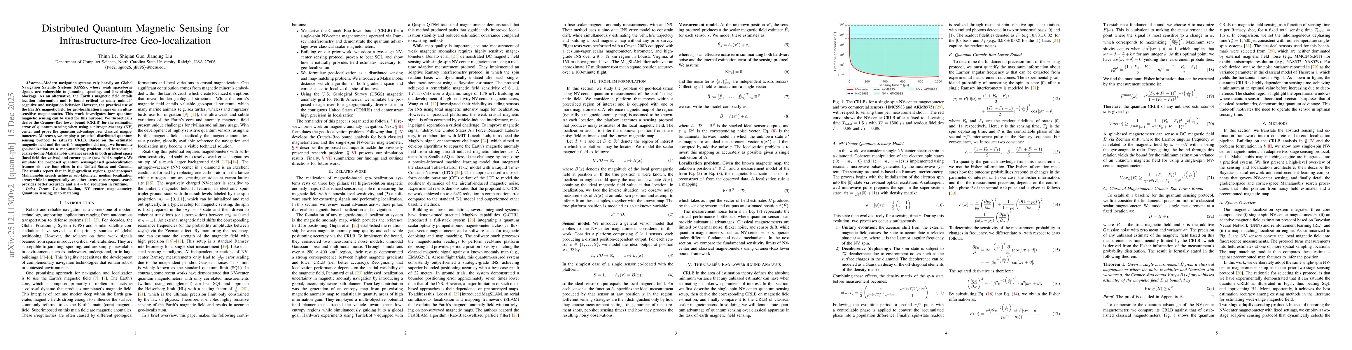
Modern navigation systems rely heavily on Global Navigation Satellite Systems (GNSS), whose weak spaceborne signals are vulnerable to jamming, spoofing, and line-of-sight blockage. As an alternative, the Earth's magnetic field entails location information and is found critical to many animals' cognitive and navigation behavior. However, the practical use of the Earth's magnetic field for geo-localization hinges on an ultra-sensitive magnetometer. This work investigates how quantum magnetic sensing can be used for this purpose. We theoretically derive the Cramér-Rao lower bound (CRLB) for the estimation error of quantum sensing when using a nitrogen-vacancy (NV) center and prove the quantum advantage over classical magnetometers. Moreover, we employ a practical distributed quantum sensing protocol to saturate CRLB. Based on the estimated magnetic field and the earth's magnetic field map, we formulate geo-localization as a map-matching problem and introduce a coarse-to-fine Mahalanobis distance search in both gradient space (local field derivatives) and corner space (raw field samples). We simulate the proposed quantum sensing-based geo-localization framework over four cities in the United States and Canada. The results report that in high-gradient regions, gradient-space Mahalanobis search achieves sub-kilometer median localization error; while in magnetically smoother areas, corner-space search provides better accuracy and a $4-8\times$ reduction in runtime.
Key Findings, in focus
Seven facets of this paper, analysed and brought into focus by AI.
This work advances navigation in GNSS-denied environments by leveraging quantum sensors and map-based localization, offering a viable solution for infrastructure-free positioning.
- Achieved nT-level magnetic field estimation accuracy
- Sub-kilometer median localization error under realistic sensing budgets
- Corner-space formulation provides better accuracy in smooth magnetic regions
This work advances navigation in GNSS-denied environments by leveraging quantum sensors and map-based localization, offering a viable solution for infrastructure-free positioning.
Development of a unified problem formulation separating geometric, sensing, and inference components for magnetic localization
Integration of adaptive sensing with Mahalanobis map-matching using high-resolution magnetic anomaly data for quantum-enhanced geo-localization
- Performance degrades in areas with weak magnetic spatial structure
- Computational cost increases with larger ROI sizes
- Enhancing sensor arrays for improved spatial coverage
- Optimizing search algorithms for real-time applications
Discussion 0