Summary
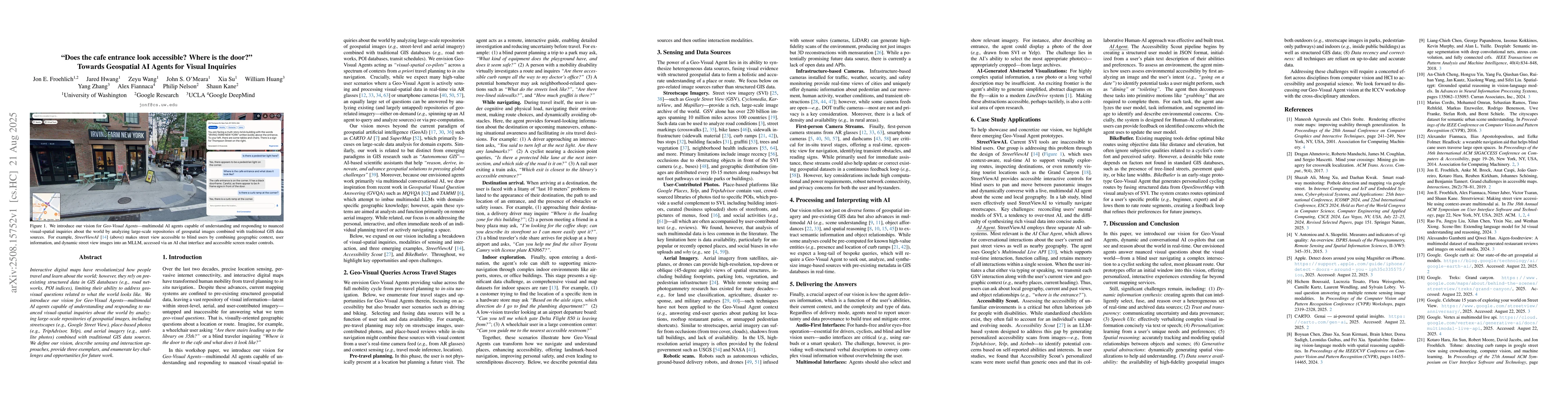
Interactive digital maps have revolutionized how people travel and learn about the world; however, they rely on pre-existing structured data in GIS databases (e.g., road networks, POI indices), limiting their ability to address geo-visual questions related to what the world looks like. We introduce our vision for Geo-Visual Agents--multimodal AI agents capable of understanding and responding to nuanced visual-spatial inquiries about the world by analyzing large-scale repositories of geospatial images, including streetscapes (e.g., Google Street View), place-based photos (e.g., TripAdvisor, Yelp), and aerial imagery (e.g., satellite photos) combined with traditional GIS data sources. We define our vision, describe sensing and interaction approaches, provide three exemplars, and enumerate key challenges and opportunities for future work.
AI Key Findings
Get AI-generated insights about this paper's methodology, results, and significance.
Paper Details
PDF Preview
Similar Papers
Found 4 papersSRAI: Towards Standardization of Geospatial AI
Piotr Szymański, Piotr Gramacki, Kacper Leśniara et al.
Superplatforms Have to Attack AI Agents
Jiachen Zhu, Jianghao Lin, Yong Yu et al.
The Benefits of Prosociality towards AI Agents: Examining the Effects of Helping AI Agents on Human Well-Being
Naomi Yamashita, Yi-Chieh Lee, Renwen Zhang et al.
Comments (0)