Publication

Published: Sep 30, 2025
Categories: eess.SP

Metrics

Source: ArXiv

Quick Actions

View PDF

Quick Answers

What methodology did the authors use?

The paper proposes a multistatic Doppler sensing system using LTE downlink signals, where LTE base stations act as signal illuminators and passive receivers detect bistatic Doppler frequencies from received signals. The trajectory is reconstructed by solving a minimum mean-squared error problem using Doppler measurements. More in Methodology →

What are the key results?

90% of tracking errors are below 0.9 meters even when the drone is 200 meters away from BSs and 20 meters from receivers. — Doppler measurements alone can provide sufficient information for trajectory reconstruction without requiring range or angle measurements. More in Key Results →

Why is this work significant?

This research enables high-accuracy drone tracking without active user connections or range/angle measurements, reducing implementation costs and enabling passive monitoring in urban environments. More in Significance →

What are the main limitations?

The system requires a sufficiently high density of receivers for accurate tracking. — The method assumes fixed altitude for drones, though 3D tracking is possible with more receivers. More in Limitations →

Paper Preview

Abstract

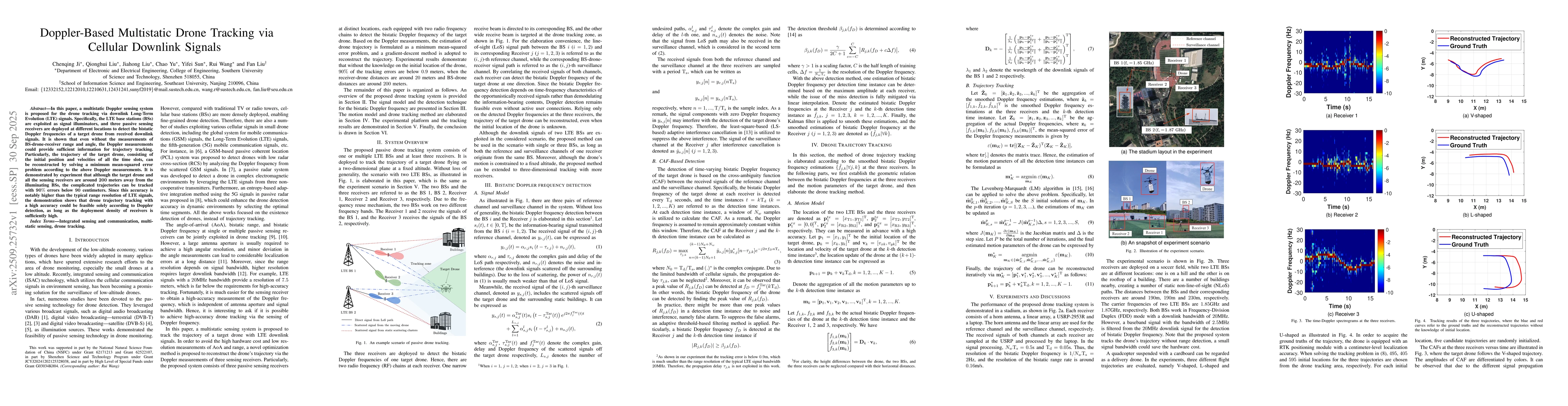
In this paper, a multistatic Doppler sensing system is proposed for the drone tracking via downlink Long-Term Evolution (LTE) signals. Specifically, the LTE base stations (BSs) are exploited as signal illuminators, and three passive sensing receivers are deployed at different locations to detect the bistatic Doppler frequencies of a target drone from received downlink signals. It is shown that even without the measurements of BS-drone-receiver range and angle, the Doppler measurements could provide sufficient information for trajectory tracking. Particularly, the trajectory of the target drone, consisting of the initial position and velocities of all the time slots, can be reconstructed by solving a minimum mean-squared error problem according to the above Doppler measurements. It is demonstrated by experiment that although the target drone and all the sensing receivers are around 200 meters away from the illuminating BSs, the complicated trajectories can be tracked with 90% errors below 90 centimeters. Since this accuracy is notably higher than the typical range resolution of LTE signals, the demonstration shows that drone trajectory tracking with a high accuracy could be feasible solely according to Doppler detection, as long as the deployment density of receivers is sufficiently high.

AI Key Findings

Generated Oct 01, 2025

Methodology — What approach did the authors take?

The paper proposes a multistatic Doppler sensing system using LTE downlink signals, where LTE base stations act as signal illuminators and passive receivers detect bistatic Doppler frequencies from received signals. The trajectory is reconstructed by solving a minimum mean-squared error problem using Doppler measurements.

Key Results — What are the main findings?

  • 90% of tracking errors are below 0.9 meters even when the drone is 200 meters away from BSs and 20 meters from receivers.
  • Doppler measurements alone can provide sufficient information for trajectory reconstruction without requiring range or angle measurements.
  • The system achieves sub-meter accuracy, surpassing the typical LTE range resolution of 20 MHz bandwidth.

Significance — Why does this research matter?

This research enables high-accuracy drone tracking without active user connections or range/angle measurements, reducing implementation costs and enabling passive monitoring in urban environments.

Technical Contribution — What is the technical contribution?

A gradient-descent method for trajectory reconstruction using Doppler measurements, combined with Kalman filtering for smoothing and interference cancellation techniques.

Novelty — What is new about this work?

The first demonstration of high-accuracy drone tracking using only Doppler detection from cellular downlink signals, without requiring active user connections or traditional angle/range measurements.

Limitations — What are the limitations of this study?

  • The system requires a sufficiently high density of receivers for accurate tracking.
  • The method assumes fixed altitude for drones, though 3D tracking is possible with more receivers.

Future Work — What did the authors propose for future work?

  • Extending the method to 3D tracking with more receivers.
  • Improving detection in complex environments with more scattering paths.
  • Integrating with other sensing modalities for robustness.

Paper Details

Paper ID: 2509.25732
Categories:
eess.SP

How to Cite This Paper

BibTeX
@article{yu2025doppler,
  title         = {Doppler-Based Multistatic Drone Tracking via Cellular Downlink Signals},
  author        = {Yu, Chao and Ji, Chenqing and Liu, Fan and others},
  year          = {2025},
  eprint        = {2509.25732},
  archivePrefix = {arXiv},
  primaryClass  = {eess.SP},
}
APA 7
Yu, C., Ji, C., Liu, F., Liu, J., Liu, Q., Wang, R., & Sun, Y. (2025). Doppler-Based Multistatic Drone Tracking via Cellular Downlink Signals. arXiv. https://arxiv.org/abs/2509.25732
MLA 9
Yu, Chao, et al. "Doppler-Based Multistatic Drone Tracking via Cellular Downlink Signals." arXiv, 2025, arxiv.org/abs/2509.25732.

Comments (0)

This website uses cookies to ensure you get the best experience. Learn more