Authors
Summary
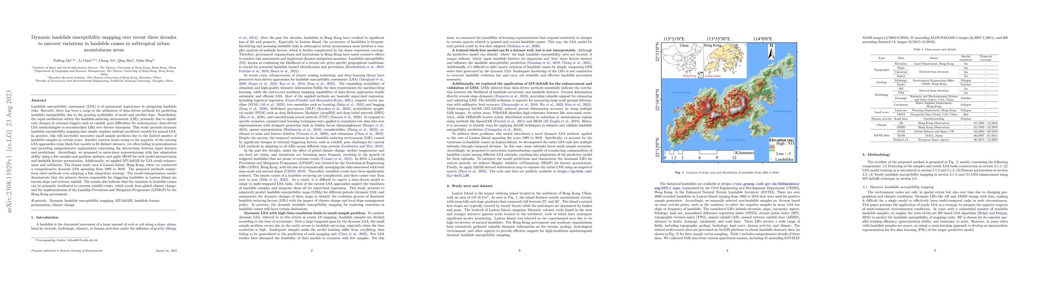
Landslide susceptibility assessment (LSA) is of paramount importance in mitigating landslide risks. Recently, there has been a surge in the utilization of data-driven methods for predicting landslide susceptibility due to the growing availability of aerial and satellite data. Nonetheless, the rapid oscillations within the landslide-inducing environment (LIE), primarily due to significant changes in external triggers such as rainfall, pose difficulties for contemporary data-driven LSA methodologies to accommodate LIEs over diverse timespans. This study presents dynamic landslide susceptibility mapping that simply employs multiple predictive models for annual LSA. In practice, this will inevitably encounter small sample problems due to the limited number of landslide samples in certain years. Another concern arises owing to the majority of the existing LSA approaches train black-box models to fit distinct datasets, yet often failing in generalization and providing comprehensive explanations concerning the interactions between input features and predictions. Accordingly, we proposed to meta-learn representations with fast adaptation ability using a few samples and gradient updates; and apply SHAP for each model interpretation and landslide feature permutation. Additionally, we applied MT-InSAR for LSA result enhancement and validation. The chosen study area is Lantau Island, Hong Kong, where we conducted a comprehensive dynamic LSA spanning from 1992 to 2019. The model interpretation results demonstrate that the primary factors responsible for triggering landslides in Lantau Island are terrain slope and extreme rainfall. The results also indicate that the variation in landslide causes can be primarily attributed to extreme rainfall events, which result from global climate change, and the implementation of the Landslip Prevention and Mitigation Programme (LPMitP) by the Hong Kong government.
AI Key Findings
Get AI-generated insights about this paper's methodology, results, and significance.
Paper Details
PDF Preview
Key Terms
Citation Network
Current paper (gray), citations (green), references (blue)
Display is limited for performance on very large graphs.
Similar Papers
Found 4 papersHyper-parameter optimization for enhanced machine learning-based landslide susceptibility mapping.
Ado, Moziihrii, Amitab, Khwairakpam
Interpretability of Statistical, Machine Learning, and Deep Learning Models for Landslide Susceptibility Mapping in Three Gorges Reservoir Area
Lei Fan, Cheng Chen
Landslide Susceptibility Modeling by Interpretable Neural Network
Kevin Shao, Khaled Youssef, Seulgi Moon et al.
| Title | Authors | Year | Actions |
|---|
Comments (0)