Dynamic Occupancy Grids for Object Detection: A Radar-Centric Approach
Publication
Metrics
AI Quick Summary
This paper introduces a radar-centric dynamic occupancy grid mapping algorithm, optimizing state computation and radar-specific sensor models to enhance mapping accuracy. The proposed method is benchmarked using real data and establishes a new standard for radar-based dynamic occupancy grid mapping.
Paper Preview
Abstract
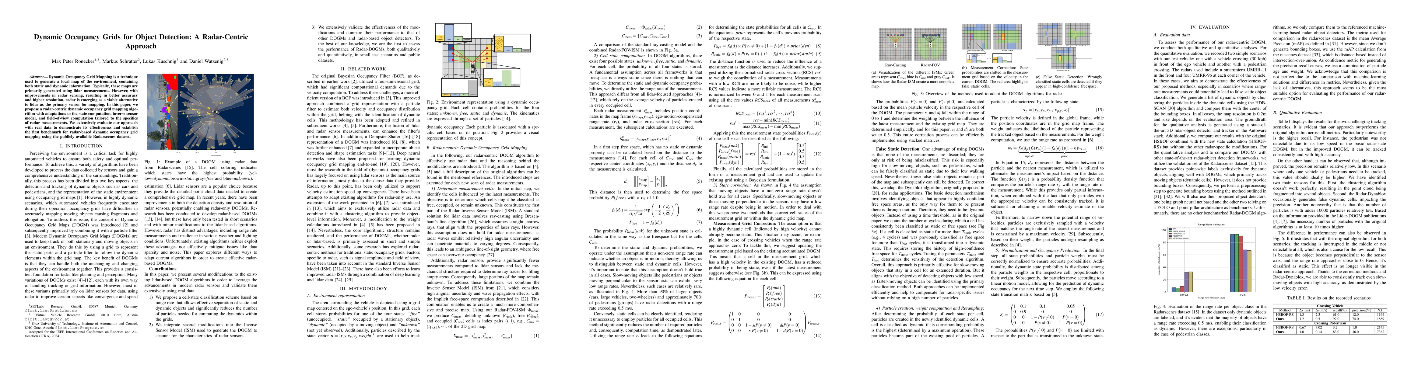
Dynamic Occupancy Grid Mapping is a technique used to generate a local map of the environment containing both static and dynamic information. Typically, these maps are primarily generated using lidar measurements. However, with improvements in radar sensing, resulting in better accuracy and higher resolution, radar is emerging as a viable alternative to lidar as the primary sensor for mapping. In this paper, we propose a radar-centric dynamic occupancy grid mapping algorithm with adaptations to the state computation, inverse sensor model, and field-of-view computation tailored to the specifics of radar measurements. We extensively evaluate our approach using real data to demonstrate its effectiveness and establish the first benchmark for radar-based dynamic occupancy grid mapping using the publicly available Radarscenes dataset.
AI Key Findings
Get AI-generated insights about this paper's methodology, results, significance, and more — seven facets brought into focus.
Impact
Paper Details
Authors
PDF Preview
Key Terms
Citation Network
Current paper (gray), citations (green), references (blue)
Display is limited for performance on very large graphs.
Discussion 0