Summary

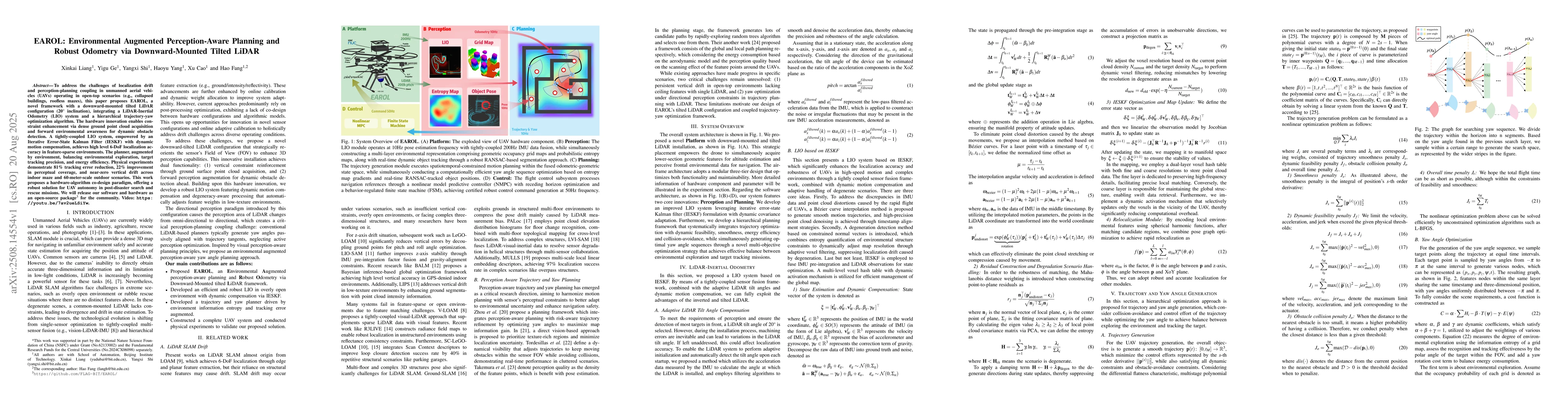
To address the challenges of localization drift and perception-planning coupling in unmanned aerial vehicles (UAVs) operating in open-top scenarios (e.g., collapsed buildings, roofless mazes), this paper proposes EAROL, a novel framework with a downward-mounted tilted LiDAR configuration (20{\deg} inclination), integrating a LiDAR-Inertial Odometry (LIO) system and a hierarchical trajectory-yaw optimization algorithm. The hardware innovation enables constraint enhancement via dense ground point cloud acquisition and forward environmental awareness for dynamic obstacle detection. A tightly-coupled LIO system, empowered by an Iterative Error-State Kalman Filter (IESKF) with dynamic motion compensation, achieves high level 6-DoF localization accuracy in feature-sparse environments. The planner, augmented by environment, balancing environmental exploration, target tracking precision, and energy efficiency. Physical experiments demonstrate 81% tracking error reduction, 22% improvement in perceptual coverage, and near-zero vertical drift across indoor maze and 60-meter-scale outdoor scenarios. This work proposes a hardware-algorithm co-design paradigm, offering a robust solution for UAV autonomy in post-disaster search and rescue missions. We will release our software and hardware as an open-source package for the community. Video: https://youtu.be/7av2ueLSiYw.

AI Key Findings

Generated Aug 21, 2025

Methodology

The paper proposes EAROL, a framework for UAVs with a downward-mounted tilted LiDAR (20° inclination), integrating a LiDAR-Inertial Odometry (LIO) system and a hierarchical trajectory-yaw optimization algorithm for robust odometry and perception-aware planning in open-top scenarios.

Key Results

  • 81% reduction in tracking error
  • 22% improvement in perceptual coverage
  • Near-zero vertical drift in both indoor maze and outdoor scenarios
  • Balancing environmental exploration, target tracking precision, and energy efficiency in the planner

Significance

This research offers a robust solution for UAV autonomy in post-disaster search and rescue missions, addressing persistent vertical drift and yaw optimization challenges in open-top environments.

Technical Contribution

EAROL's hardware-algorithm co-design, including adaptive LiDAR tilt angle compensation, improved LIO system based on Iterative Error-State Kalman Filter (IESKF), and a hierarchical planning framework for trajectory optimization and yaw angle generation

Novelty

The proposed framework combines a novel LiDAR mounting configuration, a tightly-coupled LIO system with dynamic motion compensation, and a hierarchical planning approach to address the challenges of localization drift and perception-planning coupling in UAVs operating in open-top scenarios.

Limitations

  • The study was conducted in controlled indoor and outdoor scenarios; real-world performance may vary
  • Hardware and software will be released as open-source, but broader applicability and adaptability to diverse environments need further validation

Future Work

  • Optimizing flight velocity while integrating semantic-aware modules for multi-modal sensing
  • Extending the solution for various UAV platforms and operational constraints

Paper Details

PDF Preview

Download PDF

Comments (0)

This website uses cookies to ensure you get the best experience. Learn more