EarthMarker: Visual Prompt Learning for Region-level and Point-level Remote Sensing Imagery Comprehension
Publication
Metrics
AI Quick Summary
EarthMarker introduces a visual prompting model for remote sensing imagery comprehension, excelling in region-level and point-level interpretations, and overcoming challenges of existing models through adaptive learning and a novel visual encoding method. It also constructs a new dataset, RSVP, to address data scarcity, showcasing competitive performance in multi-granularity remote sensing imagery analysis.
Paper Preview
Abstract
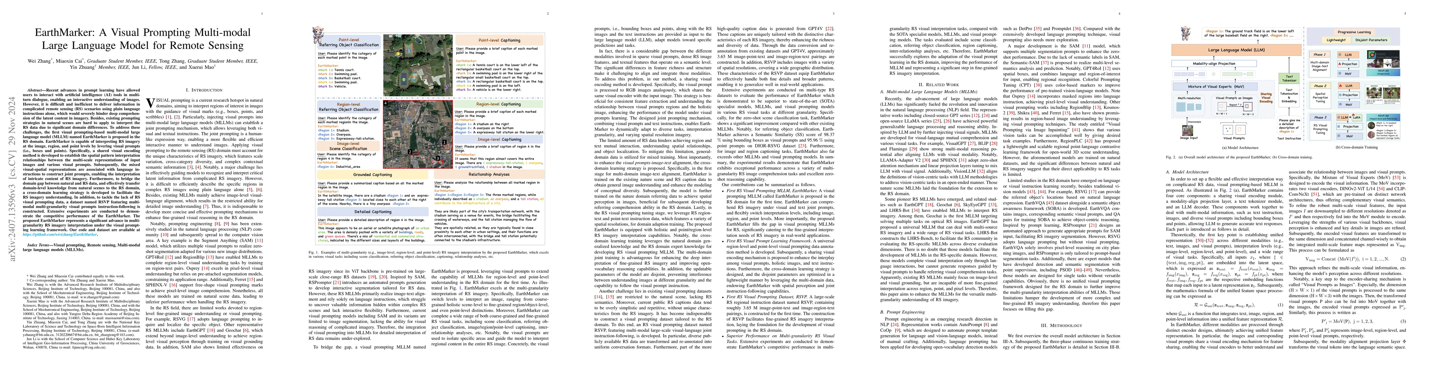
Recent advances in visual prompting in the natural image area have allowed users to interact with artificial intelligence (AI) tools through various visual marks such as box, point, and free-form shapes. However, due to the significant difference between the natural and remote sensing (RS) images, existing visual prompting models face challenges in RS scenarios. Moreover, RS MLLMs mainly focus on interpreting image-level RS data and only support interaction with language instruction, restricting flexibility applications in the real world. To address those limitations, the first visual prompting model named EarthMarker is proposed, which excels in image-level, region-level, and point-level RS imagery interpretation. Specifically, the visual prompts alongside images and text instruction input into the large language model (LLM), adapt models toward specific predictions and tasks. Subsequently, a sharing visual encoding method is introduced to refine multi-scale image features and visual prompt information uniformly. Furthermore, to endow the EarthMarker with versatile multi-granularity visual perception abilities, the cross-domain phased learning strategy is developed, and the disjoint parameters are optimized in a lightweight manner by leveraging both the natural and RS domain-specific knowledge. In addition, to tackle the lack of RS visual prompting data, a dataset named RSVP featuring multi-modal fine-grained visual prompting instruction is constructed. Extensive experiments are conducted to demonstrate the proposed EarthMarker's competitive performance, representing a significant advance in multi-granularity RS imagery interpretation under the visual prompting learning framework.
AI Key Findings
Get AI-generated insights about this paper's methodology, results, significance, and more — seven facets brought into focus.
Impact
Authors
PDF Preview
Key Terms
Citation Network
Current paper (gray), citations (green), references (blue)
Display is limited for performance on very large graphs.
Discussion 0