Publication
Metrics
AI Quick Summary
This paper develops tools to analyze Conditional Average Treatment Effects (CATEs) from satellite imagery in randomized controlled trials (RCTs), finding that sequence models yield better detection of heterogeneity. It applies these tools to two RCTs, demonstrating how satellite data can enhance causal analysis and highlighting the implications of data, model, and evaluation metric choices for RCTs.
Paper Preview
Abstract
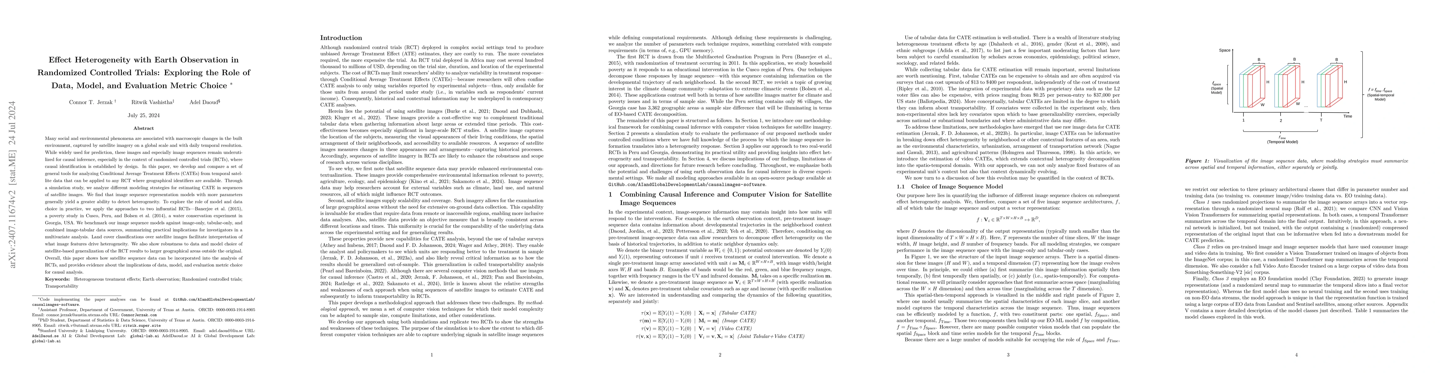
Many social and environmental phenomena are associated with macroscopic changes in the built environment, captured by satellite imagery on a global scale and with daily temporal resolution. While widely used for prediction, these images and especially image sequences remain underutilized for causal inference, especially in the context of randomized controlled trials (RCTs), where causal identification is established by design. In this paper, we develop and compare a set of general tools for analyzing Conditional Average Treatment Effects (CATEs) from temporal satellite data that can be applied to any RCT where geographical identifiers are available. Through a simulation study, we analyze different modeling strategies for estimating CATE in sequences of satellite images. We find that image sequence representation models with more parameters generally yield a greater ability to detect heterogeneity. To explore the role of model and data choice in practice, we apply the approaches to two influential RCTs -- Banerjee et al. (2015), a poverty study in Cusco, Peru, and Bolsen et al. (2014), a water conservation experiment in Georgia, USA. We benchmark our image sequence models against image-only, tabular-only, and combined image-tabular data sources, summarizing practical implications for investigators in a multivariate analysis. Land cover classifications over satellite images facilitate interpretation of what image features drive heterogeneity. We also show robustness to data and model choice of satellite-based generalization of the RCT results to larger geographical areas outside the original. Overall, this paper shows how satellite sequence data can be incorporated into the analysis of RCTs, and provides evidence about the implications of data, model, and evaluation metric choice for causal analysis.
AI Key Findings
Get AI-generated insights about this paper's methodology, results, significance, and more — seven facets brought into focus.
Impact
Authors
PDF Preview
Citation Network
Current paper (gray), citations (green), references (blue)
Display is limited for performance on very large graphs.
Discussion 0