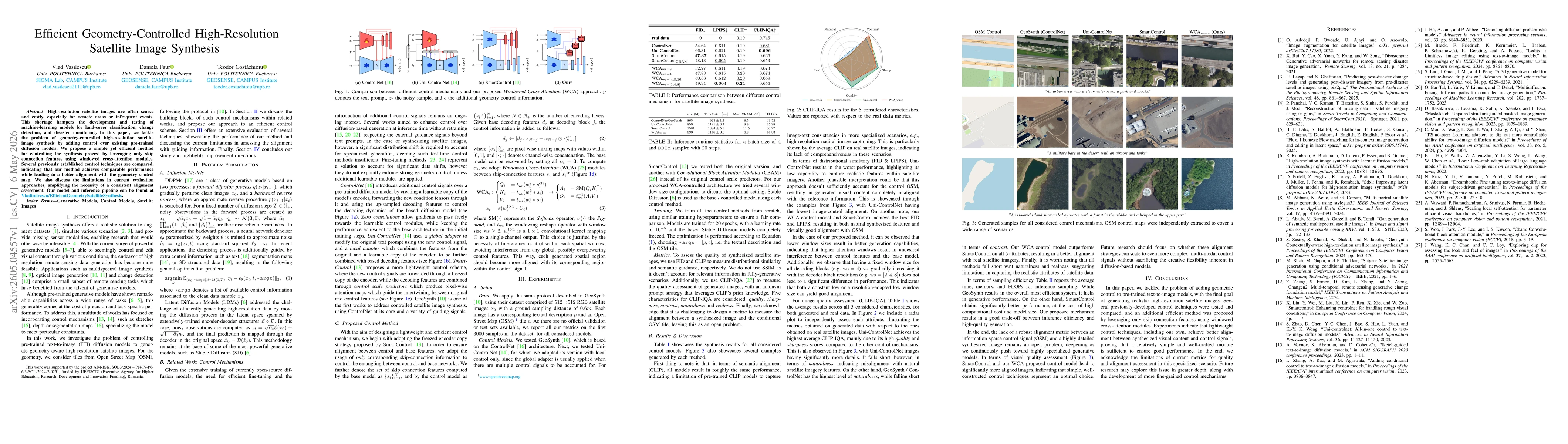
Quick Answers
What methodology did the authors use?
We introduce a lightweight geometry-control approach for pre-trained diffusion models by leveraging skip-connection features and windowed cross-attention (WCA) to fuse control signals with base features. The control signals derive from an OpenStreetMap (OSM) geometry map, and the control module integrates via per-layer skip features using pixel-wise mixing maps, with WCA computing attention within local spatial windows to align generated content... More in Methodology →
What are the key results?
The proposed WCA-based control achieves comparable distributional quality to baseline control methods while improving alignment with the geometry control map. — Empirical results show that smaller attention windows yield better generation quality and alignment, whereas larger windows can introduce interference between control and base features. More in Key Results →
Why is this work significant?
Demonstrates that a lightweight, skip-connection–based control scheme with windowed cross-attention can effectively steer pre-trained diffusion models toward geometry-consistent high-resolution satellite image synthesis without extensive retraining or large additional modules. More in Significance →
What are the main limitations?
Evaluation metrics underrepresent alignment with conditional geometry, indicating a need for more robust alignment assessments. — Quantitative alignment measures between generated outputs and OSMA tiles remain an open problem with existing metrics. More in Limitations →
Abstract
High-resolution satellite images are often scarce and costly, especially for remote areas or infrequent events. This shortage hampers the development and testing of machine learning models for land-cover classification, change detection, and disaster monitoring. In this paper, we tackle the problem of geometry-controlled high-resolution satellite image synthesis by adding control over existing pre-trained diffusion models. We propose a simple yet efficient method for controlling the synthesis process by leveraging only skip connection features using windowed cross-attention modules. Several previously established control techniques are compared, indicating that our method achieves comparable performance while leading to a better alignment with the geometry control map. We also discuss the limitations in current evaluation approaches, amplifying the necessity of a consistent alignment assessment.
AI Key Findings
Generated May 08, 2026
Methodology — What approach did the authors take?
We introduce a lightweight geometry-control approach for pre-trained diffusion models by leveraging skip-connection features and windowed cross-attention (WCA) to fuse control signals with base features. The control signals derive from an OpenStreetMap (OSM) geometry map, and the control module integrates via per-layer skip features using pixel-wise mixing maps, with WCA computing attention within local spatial windows to align generated content with geometry.
Key Results — What are the main findings?
- The proposed WCA-based control achieves comparable distributional quality to baseline control methods while improving alignment with the geometry control map.
- Empirical results show that smaller attention windows yield better generation quality and alignment, whereas larger windows can introduce interference between control and base features.
- Across metrics, the WCA approach and SmartControl provide the best balance of image fidelity (FID/LPIPS) and alignment with the control geometry, outperforming Uni-ControlNet in alignment.
- Inference efficiency is favorable: the proposed method attains a good trade-off between speed, memory usage, and quality relative to full fine-tuning baselines.
Significance — Why does this research matter?
Demonstrates that a lightweight, skip-connection–based control scheme with windowed cross-attention can effectively steer pre-trained diffusion models toward geometry-consistent high-resolution satellite image synthesis without extensive retraining or large additional modules.
Technical Contribution — What is the technical contribution?
A lightweight control mechanism that uses only skip-connection features and windowed cross-attention to fuse geometry control maps into pre-trained diffusion models for high-resolution satellite image synthesis.
Novelty — What is new about this work?
Proposes a geometry-control method that avoids full fine-tuning by applying WCA-based fusion on skip features, yielding strong alignment with geometry while maintaining efficiency and competitive image quality.
Limitations — What are the limitations of this study?
- Evaluation metrics underrepresent alignment with conditional geometry, indicating a need for more robust alignment assessments.
- Quantitative alignment measures between generated outputs and OSMA tiles remain an open problem with existing metrics.
- Performance is sensitive to window size in WCA, requiring careful hyperparameter selection for different decoding stages.
Future Work — What did the authors propose for future work?
- Develop more precise alignment metrics between synthesized content and geometry control maps to better quantify geometry fidelity.
- Explore adaptive or multi-scale windowing strategies in WCA to further improve alignment across resolutions.
- Investigate integration with additional control signals (e.g., depth, segmentation) to extend geometry-controlled synthesis to multi-modal remote sensing tasks.
Paper Details
How to Cite This Paper
@article{faur2026efficient,
title = {Efficient Geometry-Controlled High-Resolution Satellite Image Synthesis},
author = {Faur, Daniela and Costachioiu, Teodor and Vasilescu, Vlad},
year = {2026},
eprint = {2605.04557},
archivePrefix = {arXiv},
primaryClass = {cs.CV},
}
Faur, D., Costachioiu, T., & Vasilescu, V. (2026). Efficient Geometry-Controlled High-Resolution Satellite Image Synthesis. arXiv. https://arxiv.org/abs/2605.04557
Faur, Daniela, et al. "Efficient Geometry-Controlled High-Resolution Satellite Image Synthesis." arXiv, 2026, arxiv.org/abs/2605.04557.
PDF Preview
Similar Papers
Found 4 papersGeoSynth: Contextually-Aware High-Resolution Satellite Image Synthesis
Srikumar Sastry, Subash Khanal, Aayush Dhakal et al.
DiM: Diffusion Mamba for Efficient High-Resolution Image Synthesis
Yao Teng, Yue Wu, Han Shi et al.
Frequency-Aware Autoregressive Modeling for Efficient High-Resolution Image Synthesis
Zhuokun Chen, Jugang Fan, Zhuowei Yu et al.
SANA: Efficient High-Resolution Image Synthesis with Linear Diffusion Transformers
Enze Xie, Junsong Chen, Junyu Chen et al.
Comments (0)