ArxivLens

Quick Summary:

This paper proposes a reinforcement learning method to efficiently map poverty using high-resolution satellite imagery, leveraging low-resolution images to identify optimal locations for acquiring high-resolution data. The approach achieves superior performance in poverty prediction in Uganda while significantly reducing the use of costly high-resolution images.

arXiv Id: 2006.04224
Comments: Accepted at AAAI 2021
Date Published: 2021-01-06
Date Updated: 2021-01-06

Categories:

Key Terms (TF-IDF):

high resolution (0.327)
high resolution (0.310)
resolution (0.276)
resolution (0.260)
images (0.190)
task (0.183)
images (0.180)
task (0.175)
high (0.173)
high (0.169)
approach (0.160)
prediction (0.158)
approach (0.154)
prediction (0.151)
learning (0.149)
object detection (0.143)
learning (0.143)
forest (0.140)
accuracy (0.139)
based approaches (0.137)
License: http://arxiv.org/licenses/nonexclusive-distrib/1.0/

Summary:

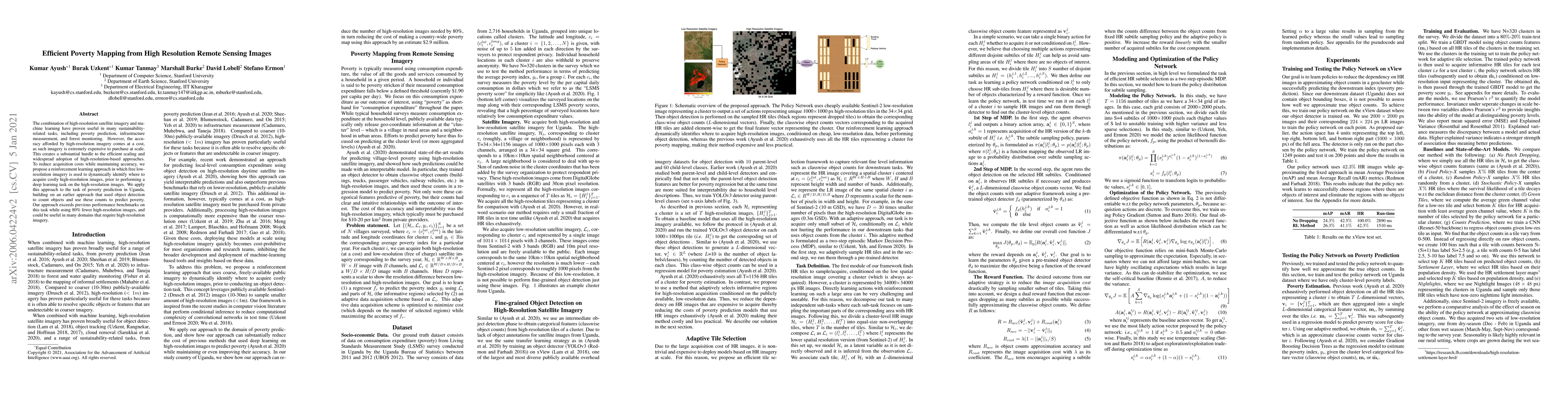
The combination of high-resolution satellite imagery and machine learning have proven useful in many sustainability-related tasks, including poverty prediction, infrastructure measurement, and forest monitoring. However, the accuracy afforded by high-resolution imagery comes at a cost, as such imagery is extremely expensive to purchase at scale. This creates a substantial hurdle to the efficient scaling and widespread adoption of high-resolution-based approaches. To reduce acquisition costs while maintaining accuracy, we propose a reinforcement learning approach in which free low-resolution imagery is used to dynamically identify where to acquire costly high-resolution images, prior to performing a deep learning task on the high-resolution images. We apply this approach to the task of poverty prediction in Uganda, building on an earlier approach that used object detection to count objects and use these counts to predict poverty. Our approach exceeds previous performance benchmarks on this task while using 80% fewer high-resolution images. Our approach could have application in many sustainability domains that require high-resolution imagery.

Citation & Reference Network Visualization

This graph shows how this paper is connected to other research. The current paper is shown in dark gray, papers that cite it are in green, and papers it references are in blue. You can:

Current Paper
Papers citing this work (Citations)
Papers cited by this work (References)

• Hover over any node to see the paper title

• Click a node to view that paper's details

• Drag nodes to rearrange the graph

• Use the zoom controls (bottom right) to zoom in/out

Citations and References

Title Authors Year Actions
Poverty Mapping with Satellite Vision for Social Good Using R-CNN Algorithm
N. S, Gerigi Charan Kumar, Karthik. M, J. S
2025
View Paper
Analyzing Poverty through Intra-Annual Time-Series: A Wavelet Transform Approach
Mohammad Kakooei, Klaudia Solska, Adel Daoud
2024
View Paper
A simple classification and clustering of poverty in rural areas using machine learning
D. B. Lasfeto, Tuti Setyorini, James Josias Mauta, Melchior Bria, Obed Nenobais
2024
View Paper
Opportunities and Challenges of Remote Sensing, Geospatial Data, and Machine Learning in Obtaining Accessibility and Location Information for Sustainable Development in Indonesia
Terry Devara
2023
View Paper
Deep Learning Methods Used in Remote Sensing Images: A Review
E. Rewehel, Ling Jianqiang, Amal Hamed, H. Keshk, Amira S. Mahmoud, Sayed A. Sayed, Ehab Samir, H. Zeyada, M. Mostafa, A. Nasr, A. Helmy
2023
View Paper
What matters in the new field of machine learning and satellite imagery-based poverty predictions? A review with relevance for potential downstream applications and development research
Ola Hall, Francis Dompae, I. Wahab, F. Dzanku
2022
View Paper
Welfare estimations from imagery. A test of domain experts ability to rate poverty from visual inspection of satellite imagery
W. Ibrahim, Ola Hall
2022
View Paper
Comparison of machine learning predictions of subjective poverty in rural China
Lucie Maruejols, Hanjie Wang, Qiran Zhao, Yunli Bai, Linxiu Zhang
2022
View Paper
Aerial View Localization with Reinforcement Learning: Towards Emulating Search-and-Rescue
Aleksis Pirinen, A. Samuelsson, John Backsund, Kalle Åström
2022
View Paper
Predicting Livelihood Indicators from Community-Generated Street-Level Imagery
Jihyeon Lee, Dylan Grosz, Burak Uzkent, Sicheng Zeng, M. Burke, D. Lobell, Stefano Ermon
2021
View Paper
Using Distance Correlation for Efficient Bayesian Optimization
T. Kanazawa
2021
View Paper
Poverty Classification Using Machine Learning: The Case of Jordan
A. Alsharkawi, Mohammad Al-Fetyani, Maha Dawas, H. Saadeh, Musa Alyaman
2021
View Paper
Geography-Aware Self-Supervised Learning
Kumar Ayush, Burak Uzkent, Chenlin Meng, K. Tanmay, M. Burke, D. Lobell, Stefano Ermon
2020
View Paper
Predicting Livelihood Indicators from Crowdsourced Street Level Images
Jihyeon Janel Lee, Dylan Grosz, Sicheng Zeng, Burak Uzkent, M. Burke, D. Lobell, Stefano Ermon
2020
View Paper
Increasing the Confidence of Predictive Uncertainty: Earth Observations and Deep Learning for Poverty Estimation
Mohammad Kakooei, Adel Daoud
2024
View Paper
Aerial View Goal Localization with Reinforcement Learning
Aleksis Pirinen, A. Samuelsson, John Backsund, Kalle Åström
2022
View Paper

Similar Papers

Optimizing Memory Mapping Using Deep Reinforcement Learning

Po-Sen Huang, Oriol Vinyals, Manish Purohit, Edouard Leurent, Phitchaya Mangpo Phothilimthana, Cosmin Paduraru, Kieran Milan, Julian Schrittwieser, Daniel J. Mankowitz, Miaosen Wang, Paula Kurylowicz, Pengming Wang, Mikita Sazanovich, Berkin Ilbeyi, Han Yang Tay, Ngân Vũ, Anton Zhernov, Thomas Hubert, Robert Tung

Published: 2023-10-18

Comments (0)

This website uses cookies to ensure you get the best experience. Learn more