Encoder-Decoder based CNN and Fully Connected CRFs for Remote Sensed Image Segmentation

Source: ArXiv

AI Quick Summary

A deep learning model combines a CNN with skip connections and atrous convolutions for land cover segmentation in VHR images, achieving 90.5% accuracy on the ISPRS Vaihingen Dataset.

Share: Share on X LinkedIn

Summary

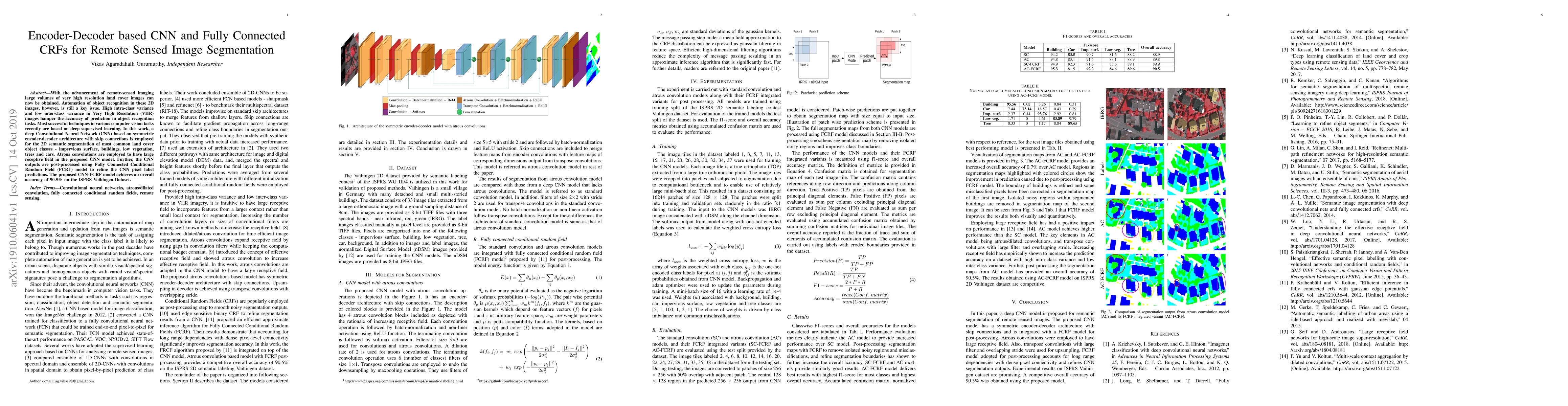
With the advancement of remote-sensed imaging large volumes of very high resolution land cover images can now be obtained. Automation of object recognition in these 2D images, however, is still a key issue. High intra-class variance and low inter-class variance in Very High Resolution (VHR) images hamper the accuracy of prediction in object recognition tasks. Most successful techniques in various computer vision tasks recently are based on deep supervised learning. In this work, a deep Convolutional Neural Network (CNN) based on symmetric encoder-decoder architecture with skip connections is employed for the 2D semantic segmentation of most common land cover object classes - impervious surface, buildings, low vegetation, trees and cars. Atrous convolutions are employed to have large receptive field in the proposed CNN model. Further, the CNN outputs are post-processed using Fully Connected Conditional Random Field (FCRF) model to refine the CNN pixel label predictions. The proposed CNN-FCRF model achieves an overall accuracy of 90.5% on the ISPRS Vaihingen Dataset.

AI Key Findings

Generated Sep 03, 2025

Methodology

The research employs a deep Convolutional Neural Network (CNN) based on a symmetric encoder-decoder architecture with skip connections, using atrous convolutions for large receptive fields. The CNN outputs are post-processed with a Fully Connected Conditional Random Field (FCRF) model to refine pixel label predictions.

Key Results

  • The proposed CNN-FCRF model achieves an overall accuracy of 90.5% on the ISPRS Vaihingen Dataset.
  • The atrous convolution model outperforms a standard convolution model in segmentation tasks.
  • Post-processing with FCRF further increases overall accuracy and removes isolated noisy regions and misclassifications, refining segmentation boundaries.

Significance

This research contributes to the automation of object recognition in high-resolution land cover images, addressing the challenges of intra-class and inter-class variance, which is crucial for applications like urban planning, environmental monitoring, and disaster management.

Technical Contribution

The paper introduces an encoder-decoder CNN architecture with atrous convolutions and skip connections, combined with a Fully Connected CRF for post-processing, to achieve high accuracy in remote sensing image segmentation.

Novelty

The proposed method combines atrous convolutions for large receptive fields with a Fully Connected CRF for post-processing, which has not been extensively explored in previous research for remote sensing image segmentation.

Limitations

  • The study is limited to specific land cover object classes (impervious surface, buildings, low vegetation, trees, and cars).
  • The performance may vary for other types of remote sensing images or datasets.

Future Work

  • Explore the application of the proposed method on other datasets and various land cover object classes.
  • Investigate the integration of additional advanced techniques, such as attention mechanisms or transformer models, to further improve segmentation accuracy.

Paper Details

PDF Preview

Download PDF

Key Terms

cnn (0.318)
cnn (0.301)
object (0.197)
object (0.195)
cover (0.192)
cover (0.190)
variance (0.186)
variance (0.185)

Citation Network

Current paper (gray), citations (green), references (blue)

Display is limited for performance on very large graphs.

Current Paper
Citations
References
Click to view

No citations found for this paper.

Comments (0)

This website uses cookies to ensure you get the best experience. Learn more