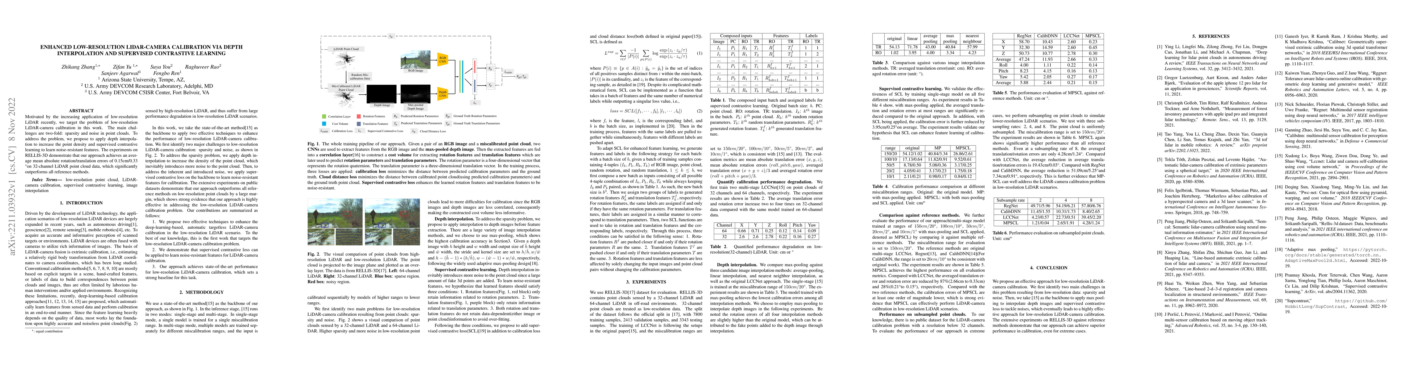
Publication

Published: Nov 09, 2022
Categories: cs.CV, cs.MM

Metrics

Source: ArXiv

Quick Actions

View PDF

AI Quick Summary

This paper proposes a method for calibrating low-resolution LiDAR-camera systems using depth interpolation to enhance point cloud density and supervised contrastive learning to extract noise-resistant features. Experimental results on RELLIS-3D show superior performance with mean absolute errors of 0.15cm/0.33°, outperforming existing methods.

Quick Answers

What methodology did the authors use?

The research proposes a method for low-resolution LiDAR-camera calibration using depth interpolation and supervised contrastive learning to address sparsity and noise issues in point clouds. It employs max-pooling for depth image interpolation and introduces supervised contrastive loss to learn noise-resistant features. More in Methodology →

What are the key results?

The approach achieves an average mean absolute rotation/translation error of 0.15cm/0.33° on 32-channel LiDAR point cloud data. — Max-pooling interpolation outperforms other image interpolation methods (average-pooling, linear interpolation, nearest neighbor interpolation) in calibration accuracy. More in Key Results →

Why is this work significant?

This research is significant as it tackles the challenges of low-resolution LiDAR-camera calibration, which is crucial for autonomous driving and other applications relying on LiDAR and camera data fusion. The proposed method enhances calibration accuracy, enabling more reliable perception systems. More in Significance →

What are the main limitations?

The study is limited to the RELLIS-3D dataset, which may not cover all real-world scenarios. — The performance of the method might vary with different LiDAR and camera hardware configurations not represented in the RELLIS-3D dataset. More in Limitations →

Paper Preview

Abstract

Motivated by the increasing application of low-resolution LiDAR recently, we target the problem of low-resolution LiDAR-camera calibration in this work. The main challenges are two-fold: sparsity and noise in point clouds. To address the problem, we propose to apply depth interpolation to increase the point density and supervised contrastive learning to learn noise-resistant features. The experiments on RELLIS-3D demonstrate that our approach achieves an average mean absolute rotation/translation errors of 0.15cm/0.33\textdegree on 32-channel LiDAR point cloud data, which significantly outperforms all reference methods.

AI Key Findings

Generated Sep 02, 2025

Methodology — What approach did the authors take?

The research proposes a method for low-resolution LiDAR-camera calibration using depth interpolation and supervised contrastive learning to address sparsity and noise issues in point clouds. It employs max-pooling for depth image interpolation and introduces supervised contrastive loss to learn noise-resistant features.

Key Results — What are the main findings?

  • The approach achieves an average mean absolute rotation/translation error of 0.15cm/0.33° on 32-channel LiDAR point cloud data.
  • Max-pooling interpolation outperforms other image interpolation methods (average-pooling, linear interpolation, nearest neighbor interpolation) in calibration accuracy.
  • Supervised contrastive learning (SCL) significantly reduces averaged translation and rotation errors compared to the original approach.
  • The method outperforms reference methods (LCCNet, RegNet, CalibDNN) in calibration performance, reducing errors by at least one order of magnitude.
  • MPSCL (model with max-pooling and SCL) shows significant performance even when applied to subsampled point clouds, simulating lower-resolution LiDAR scenarios.

Significance — Why does this research matter?

This research is significant as it tackles the challenges of low-resolution LiDAR-camera calibration, which is crucial for autonomous driving and other applications relying on LiDAR and camera data fusion. The proposed method enhances calibration accuracy, enabling more reliable perception systems.

Technical Contribution — What is the technical contribution?

The paper introduces an enhanced calibration method for low-resolution LiDAR-camera systems, combining depth interpolation with supervised contrastive learning to improve feature extraction and noise resistance.

Novelty — What is new about this work?

The proposed method distinguishes itself by integrating depth interpolation and supervised contrastive learning, which effectively addresses the sparsity and noise challenges inherent in low-resolution LiDAR data, outperforming existing calibration techniques.

Limitations — What are the limitations of this study?

  • The study is limited to the RELLIS-3D dataset, which may not cover all real-world scenarios.
  • The performance of the method might vary with different LiDAR and camera hardware configurations not represented in the RELLIS-3D dataset.

Future Work — What did the authors propose for future work?

  • Investigate the method's applicability to other LiDAR resolutions and datasets for broader validation.
  • Explore the impact of varying interpolation methods and SCL configurations on calibration performance.

Paper Details

Paper ID: 2211.03932
License: http://creativecommons.org/licenses/by-nc-nd/4.0/
Categories:
cs.CV cs.MM

How to Cite This Paper

BibTeX
@article{ren2022enhanced,
  title         = {Enhanced Low-resolution LiDAR-Camera Calibration Via Depth Interpolation
  and Supervised Contrastive Learning},
  author        = {Ren, Fengbo and Rao, Raghuveer and Agarwal, Sanjeev and others},
  year          = {2022},
  eprint        = {2211.03932},
  archivePrefix = {arXiv},
  primaryClass  = {cs.CV},
}
APA 7
Ren, F., Rao, R., Agarwal, S., You, S., Zhang, Z., & Yu, Z. (2022). Enhanced Low-resolution LiDAR-Camera Calibration Via Depth Interpolation
  and Supervised Contrastive Learning. arXiv. https://arxiv.org/abs/2211.03932
MLA 9
Ren, Fengbo, et al. "Enhanced Low-resolution LiDAR-Camera Calibration Via Depth Interpolation
  and Supervised Contrastive Learning." arXiv, 2022, arxiv.org/abs/2211.03932.

Key Terms

lidar (0.358)
low resolution (0.273)
point (0.189)
noise (0.182)
point cloud (0.180)
resolution (0.179)
contrastive (0.171)
approach achieves (0.167)

Citation Network

Current paper (gray), citations (green), references (blue)

Display is limited for performance on very large graphs.

Current Paper
Citations
References
Click to view
Title Authors Year Actions

Comments (0)

This website uses cookies to ensure you get the best experience. Learn more