Enhancement of land-use change modeling using convolutional neural networks and convolutional denoising autoencoders
Publication
Metrics
AI Quick Summary
This study enhances land-use change modeling using convolutional neural networks (CNN) and convolutional denoising autoencoders (CDAE). It finds that CNN-based models, particularly the hybrid conv-net, outperform traditional models in predicting land-use transitions, especially when incorporating spatial weight layers.
Paper Preview
Abstract
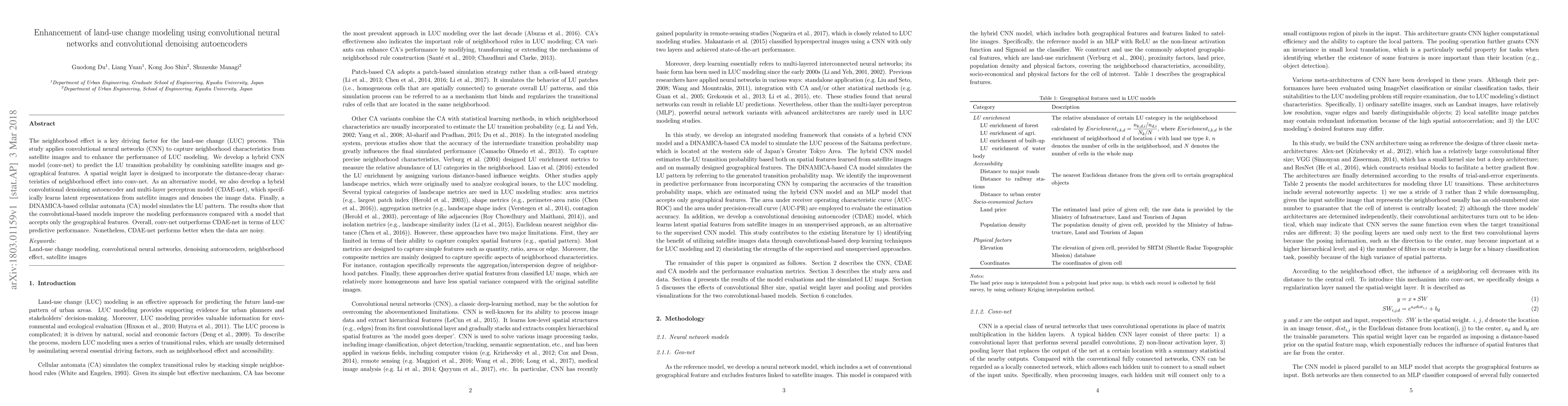
The neighborhood effect is a key driving factor for the land-use change (LUC) process. This study applies convolutional neural networks (CNN) to capture neighborhood characteristics from satellite images and to enhance the performance of LUC modeling. We develop a hybrid CNN model (conv-net) to predict the LU transition probability by combining satellite images and geographical features. A spatial weight layer is designed to incorporate the distance-decay characteristics of neighborhood effect into conv-net. As an alternative model, we also develop a hybrid convolutional denoising autoencoder and multi-layer perceptron model (CDAE-net), which specifically learns latent representations from satellite images and denoises the image data. Finally, a DINAMICA-based cellular automata (CA) model simulates the LU pattern. The results show that the convolutional-based models improve the modeling performances compared with a model that accepts only the geographical features. Overall, conv-net outperforms CDAE-net in terms of LUC predictive performance. Nonetheless, CDAE-net performs better when the data are noisy.
AI Key Findings
Get AI-generated insights about this paper's methodology, results, significance, and more — seven facets brought into focus.
Impact
Paper Details
PDF Preview
Key Terms
Citation Network
Current paper (gray), citations (green), references (blue)
Display is limited for performance on very large graphs.
Discussion 0