Enhancing Flood Impact Analysis using Interactive Retrieval of Social Media Images
Publication
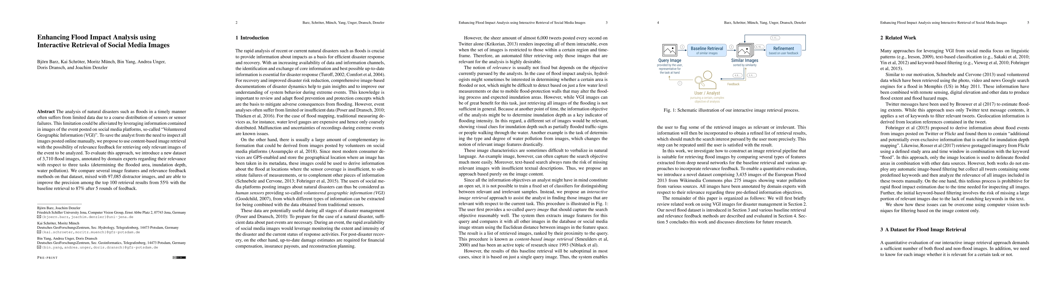
Metrics
Paper Preview
Abstract
The analysis of natural disasters such as floods in a timely manner often suffers from limited data due to a coarse distribution of sensors or sensor failures. This limitation could be alleviated by leveraging information contained in images of the event posted on social media platforms, so-called "Volunteered Geographic Information (VGI)". To save the analyst from the need to inspect all images posted online manually, we propose to use content-based image retrieval with the possibility of relevance feedback for retrieving only relevant images of the event to be analyzed. To evaluate this approach, we introduce a new dataset of 3,710 flood images, annotated by domain experts regarding their relevance with respect to three tasks (determining the flooded area, inundation depth, water pollution). We compare several image features and relevance feedback methods on that dataset, mixed with 97,085 distractor images, and are able to improve the precision among the top 100 retrieval results from 55% with the baseline retrieval to 87% after 5 rounds of feedback.
AI Key Findings
Get AI-generated insights about this paper's methodology, results, significance, and more — seven facets brought into focus.
Impact
Paper Details
Authors
PDF Preview
Key Terms
Citation Network
Current paper (gray), citations (green), references (blue)
Display is limited for performance on very large graphs.
Discussion 0