Publication
Metrics
AI Quick Summary
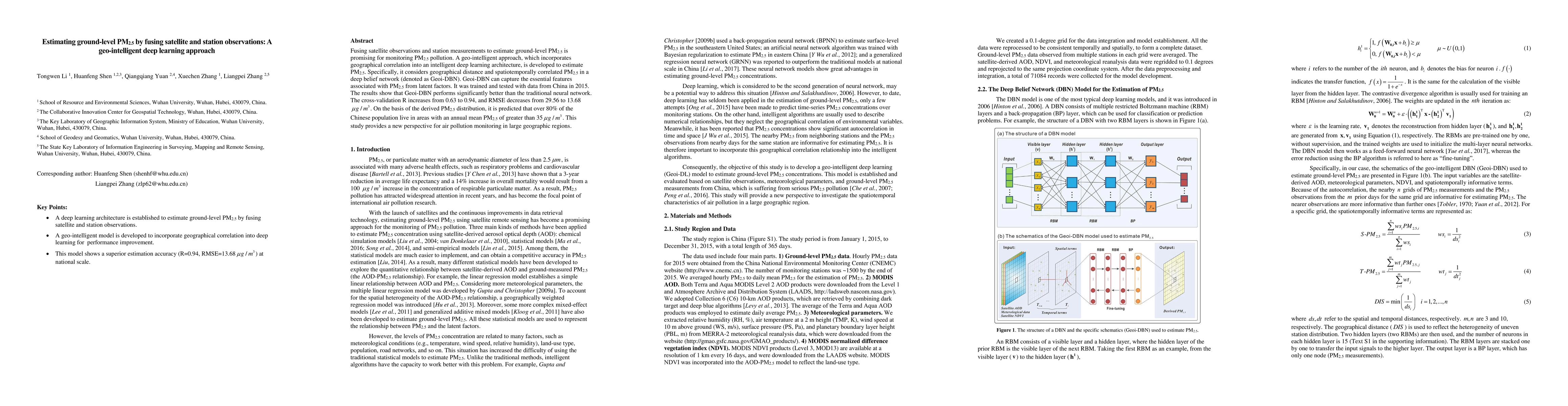
This study develops a geo-intelligent deep learning approach, Geoi-DBN, to fuse satellite and station observations for estimating ground-level PM2.5 pollution. The model significantly outperforms traditional neural networks, improving cross-validation R from 0.63 to 0.94 and reducing RMSE from 29.56 to 13.68 μg/m³.
Paper Preview
Abstract
Fusing satellite observations and station measurements to estimate ground-level PM2.5 is promising for monitoring PM2.5 pollution. A geo-intelligent approach, which incorporates geographical correlation into an intelligent deep learning architecture, is developed to estimate PM2.5. Specifically, it considers geographical distance and spatiotemporally correlated PM2.5 in a deep belief network (denoted as Geoi-DBN). Geoi-DBN can capture the essential features associated with PM2.5 from latent factors. It was trained and tested with data from China in 2015. The results show that Geoi-DBN performs significantly better than the traditional neural network. The cross-validation R increases from 0.63 to 0.94, and RMSE decreases from 29.56 to 13.68${\mu}$g/m3. On the basis of the derived PM2.5 distribution, it is predicted that over 80% of the Chinese population live in areas with an annual mean PM2.5 of greater than 35${\mu}$g/m3. This study provides a new perspective for air pollution monitoring in large geographic regions.
AI Key Findings
Get AI-generated insights about this paper's methodology, results, significance, and more — seven facets brought into focus.
Impact
Paper Details
PDF Preview
Key Terms
Citation Network
Current paper (gray), citations (green), references (blue)
Display is limited for performance on very large graphs.
Discussion 0