The study integrates MOVES with open-source data, including GPS trajectories, OpenStreetMap (OSM) road networks, regional traffic datasets, and satellite imagery. A neural network model is trained to predict operating mode distributions using features from these data sources, with preprocessing steps like map matching and local regression smoothing applied to GPS data.
Estimating link level traffic emissions: enhancing MOVES with open-source data
Publication
Metrics
Quick Answers
What methodology did the authors use?
The study integrates MOVES with open-source data, including GPS trajectories, OpenStreetMap (OSM) road networks, regional traffic datasets, and satellite imagery. A neural network model is trained to predict operating mode distributions using features from these data sources, with preprocessing steps like map matching and local regression smoothing applied to GPS data. More in Methodology →
What are the key results?
The proposed model reduces RMSE by over 50% for regional traffic emissions of CO, NOx, CO2, and PM2.5 compared to MOVES baseline. — The model achieves R² scores around 0.7 for most operating mode bins, while MOVES yields near-zero or negative R² values for several bins. More in Key Results →
Why is this work significant?
This research demonstrates a scalable, low-cost approach to traffic emissions estimation using open-source data, offering improved accuracy and replicability for urban environmental monitoring and policy-making. More in Significance →
What are the main limitations?
The model's performance may vary in areas with less spatial and temporal data coverage. — Dependence on high-quality open-source data for accurate feature extraction and training. More in Limitations →
Abstract
Open-source data offers a scalable and transparent foundation for estimating vehicle activity and emissions in urban regions. In this study, we propose a data-driven framework that integrates MOVES and open-source GPS trajectory data, OpenStreetMap (OSM) road networks, regional traffic datasets and satellite imagery-derived feature vectors to estimate the link level operating mode distribution and traffic emissions. A neural network model is trained to predict the distribution of MOVES-defined operating modes using only features derived from readily available data. The proposed methodology was applied using open-source data related to 45 municipalities in the Boston Metropolitan area. The "ground truth" operating mode distribution was established using OSM open-source GPS trajectories. Compared to the MOVES baseline, the proposed model reduces RMSE by over 50% for regional scale traffic emissions of key pollutants including CO, NOx, CO2, and PM2.5. This study demonstrates the feasibility of low-cost, replicable, and data-driven emissions estimation using fully open data sources.
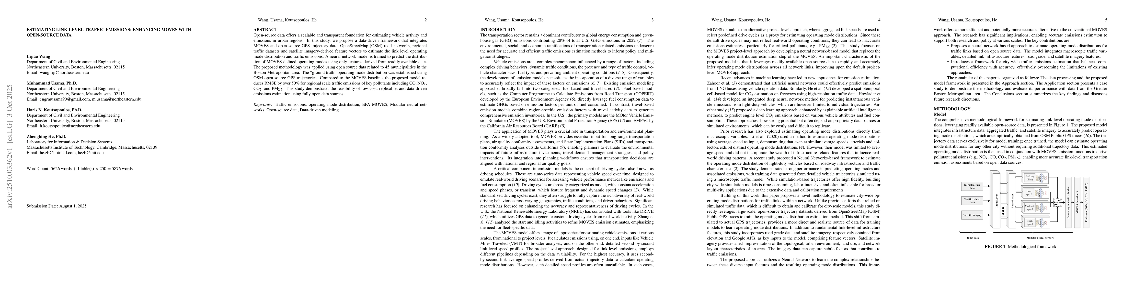
Key Findings, in focus
Seven facets of this paper, analysed and brought into focus by AI.
This research demonstrates a scalable, low-cost approach to traffic emissions estimation using open-source data, offering improved accuracy and replicability for urban environmental monitoring and policy-making.
- The proposed model reduces RMSE by over 50% for regional traffic emissions of CO, NOx, CO2, and PM2.5 compared to MOVES baseline.
- The model achieves R² scores around 0.7 for most operating mode bins, while MOVES yields near-zero or negative R² values for several bins.
- Emission estimates using the model align more closely with ground truth, achieving an R² of 0.79 for CO2 emissions compared to -0.011 for MOVES.
This research demonstrates a scalable, low-cost approach to traffic emissions estimation using open-source data, offering improved accuracy and replicability for urban environmental monitoring and policy-making.
A modular neural network framework that replaces MOVES' operating mode distribution estimation with data-driven predictions from open-source datasets, enabling scalable and accurate emissions modeling.
The integration of diverse open-source data sources (GPS, OSM, satellite imagery) with neural networks for link-level emissions estimation, offering a transparent and replicable alternative to traditional emission models.
- The model's performance may vary in areas with less spatial and temporal data coverage.
- Dependence on high-quality open-source data for accurate feature extraction and training.
- Validate and refine the model in cities with different traffic patterns and infrastructure.
- Integrate computer vision pipelines for satellite imagery to enhance traffic flow and network topology representation.
Discussion 0