The study integrates Sentinel‑2 MSI and Sentinel‑3 OLCI multispectral imagery with an XGBoost‑kernelized Kernel Ridge Regression (KRR‑XGB) model, where XGBoost leaf‑index embeddings serve as the kernel. The model is trained on monthly Taiwan seabream catch logbook data and evaluated against linear and RBF kernels.
Estimation of Fish Catch Using Sentinel-2, 3 and XGBoost-Kernel-Based Kernel Ridge Regression
Publication
Metrics
Quick Answers
What methodology did the authors use?
The study integrates Sentinel‑2 MSI and Sentinel‑3 OLCI multispectral imagery with an XGBoost‑kernelized Kernel Ridge Regression (KRR‑XGB) model, where XGBoost leaf‑index embeddings serve as the kernel. The model is trained on monthly Taiwan seabream catch logbook data and evaluated against linear and RBF kernels. More in Methodology →
What are the key results?
KRR‑XGB achieves a 59–61% reduction in RMSE for Sentinel‑2 (0.085 vs 0.218/0.210) and 28–40% for Sentinel‑3 (0.116 vs 0.194/0.160). — Correlation coefficients reach 0.924 for Sentinel‑2 and 0.731 for Sentinel‑3, indicating strong agreement with in‑situ catch. More in Key Results →
Why is this work significant?
The approach provides a scalable, sensor‑agnostic method for satellite‑based fish catch estimation, supporting sustainable fisheries management and contributing to SDG 2 (Zero Hunger) and SDG 14 (Life Below Water). More in Significance →
What are the main limitations?
The model is trained on a single species (Taiwan seabream) and a limited geographic area, which may restrict generalizability. — Cloud cover and the coarser spatial resolution of Sentinel‑3 introduce variability that could affect prediction accuracy. More in Limitations →
Abstract
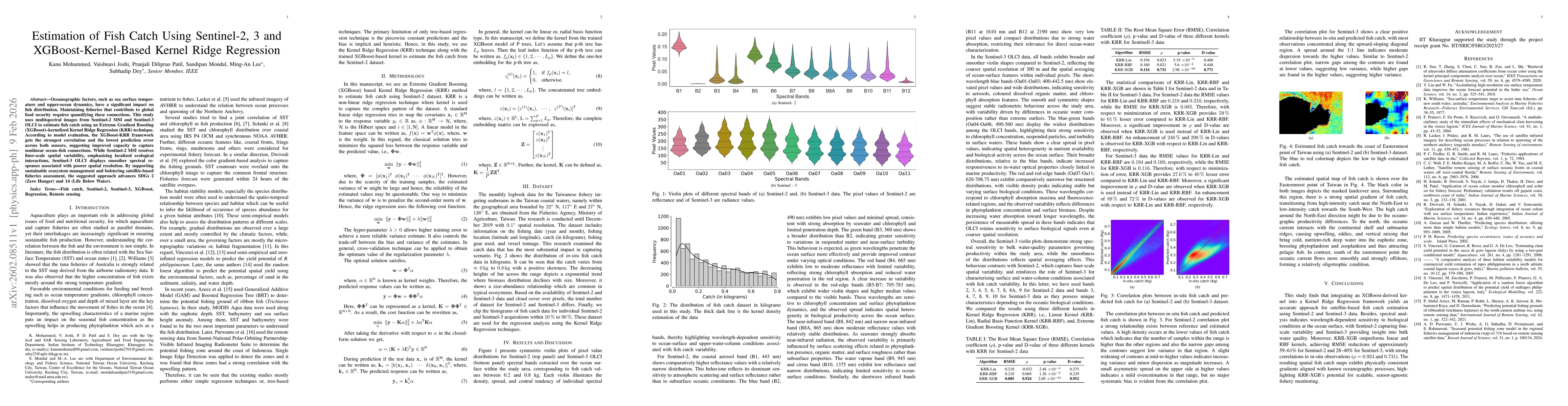
Oceanographic factors, such as sea surface temperature and upper-ocean dynamics, have a significant impact on fish distribution. Maintaining fisheries that contribute to global food security requires quantifying these connections. This study uses multispectral images from Sentinel-2 MSI and Sentinel-3 OLCI to estimate fish catch using an Extreme Gradient Boosting (XGBoost)-kernelized Kernel Ridge Regression (KRR) technique. According to model evaluation, the XGBoost-KRR framework achieves the strongest correlation and the lowest prediction error across both sensors, suggesting improved capacity to capture nonlinear ocean-fish connections. While Sentinel-2 MSI resolves finer-scale spatial variability, emphasizing localized ecological interactions, Sentinel-3 OLCI displays smoother spectral responses associated with poorer spatial resolution. By supporting sustainable ecosystem management and strengthening satellite-based fisheries assessment, the proposed approach advances SDGs 2 (Zero Hunger) and 14 (Life Below Water).
Key Findings, in focus
Seven facets of this paper, analysed and brought into focus by AI.
The approach provides a scalable, sensor‑agnostic method for satellite‑based fish catch estimation, supporting sustainable fisheries management and contributing to SDG 2 (Zero Hunger) and SDG 14 (Life Below Water).
- KRR‑XGB achieves a 59–61% reduction in RMSE for Sentinel‑2 (0.085 vs 0.218/0.210) and 28–40% for Sentinel‑3 (0.116 vs 0.194/0.160).
- Correlation coefficients reach 0.924 for Sentinel‑2 and 0.731 for Sentinel‑3, indicating strong agreement with in‑situ catch.
- Spatial catch maps reveal gradients consistent with known oceanographic processes, validating the model’s ecological relevance.
The approach provides a scalable, sensor‑agnostic method for satellite‑based fish catch estimation, supporting sustainable fisheries management and contributing to SDG 2 (Zero Hunger) and SDG 14 (Life Below Water).
The paper introduces an XGBoost‑derived kernel for KRR, demonstrating that tree‑based embeddings capture complex ocean‑fish relationships more effectively than traditional linear or RBF kernels.
It is the first study to combine XGBoost kernelization with Kernel Ridge Regression for fish catch estimation, revealing that this hybrid approach outperforms conventional kernels and leverages multispectral satellite data for ecological monitoring.
- The model is trained on a single species (Taiwan seabream) and a limited geographic area, which may restrict generalizability.
- Cloud cover and the coarser spatial resolution of Sentinel‑3 introduce variability that could affect prediction accuracy.
- Extend the methodology to additional species and regions to test generalizability.
- Incorporate higher‑frequency temporal data and complementary sensors (e.g., SAR) to improve robustness.
Discussion 0