Fast and Robust Registration of Aerial Images and LiDAR data Based on Structrual Features and 3D Phase Correlation
Publication
Metrics
AI Quick Summary
This paper proposes an automatic registration method for co-aligning aerial imagery and LiDAR data using structural features and 3D phase correlation. The method involves transforming LiDAR data into an intensity map, extracting interest points in aerial images, and employing 3D phase correlation for control point detection, achieving faster and more robust registration compared to existing methods.
Paper Preview
Abstract
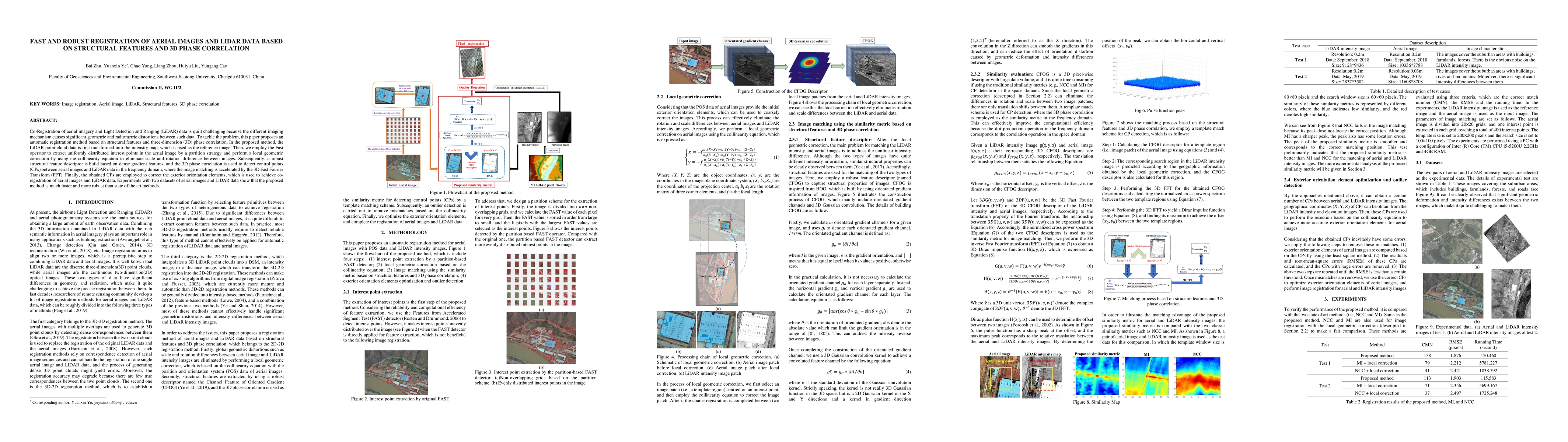
Co-Registration of aerial imagery and Light Detection and Ranging (LiDAR) data is quilt challenging because the different imaging mechanism causes significant geometric and radiometric distortions between such data. To tackle the problem, this paper proposes an automatic registration method based on structural features and three-dimension (3D) phase correlation. In the proposed method, the LiDAR point cloud data is first transformed into the intensity map, which is used as the reference image. Then, we employ the Fast operator to extract uniformly distributed interest points in the aerial image by a partition strategy and perform a local geometric correction by using the collinearity equation to eliminate scale and rotation difference between images. Subsequently, a robust structural feature descriptor is build based on dense gradient features, and the 3D phase correlation is used to detect control points (CPs) between aerial images and LiDAR data in the frequency domain, where the image matching is accelerated by the 3D Fast Fourier Transform (FFT). Finally, the obtained CPs are employed to correct the exterior orientation elements, which is used to achieve co-registration of aerial images and LiDAR data. Experiments with two datasets of aerial images and LiDAR data show that the proposed method is much faster and more robust than state of the art methods
AI Key Findings
Get AI-generated insights about this paper's methodology, results, significance, and more — seven facets brought into focus.
Impact
Paper Details
Authors
PDF Preview
Key Terms
Citation Network
Current paper (gray), citations (green), references (blue)
Display is limited for performance on very large graphs.
Discussion 0