Feature Space Exploration For Planning Initial Benthic AUV Surveys
Publication
Metrics
AI Quick Summary
This paper proposes methods for planning initial Autonomous Underwater Vehicle (AUV) surveys to efficiently explore diverse bathymetric terrain using feature space representation. Planners based on RRT and MCTS were found to be most effective in optimizing AUV paths to cover varied habitats and gather comprehensive training data for seafloor classification.
Paper Preview
Abstract
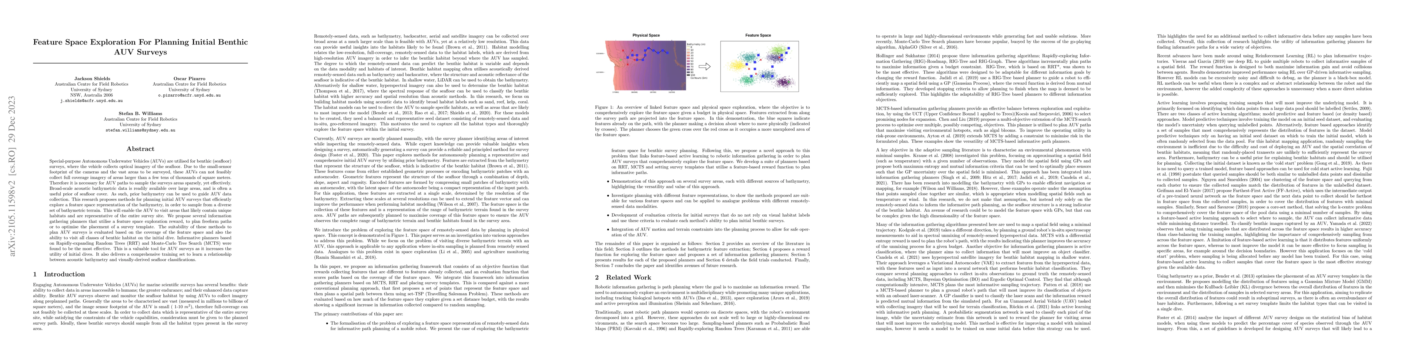
Special-purpose Autonomous Underwater Vehicles (AUVs) are utilised for benthic (seafloor) surveys, where the vehicle collects optical imagery of the seafloor. Due to the small-sensor footprint of the cameras and the vast areas to be surveyed, these AUVs can not feasibly collect full coverage imagery of areas larger than a few tens of thousands of square meters. Therefore it is necessary for AUV paths to sample the surveys areas sparsely, yet effectively. Broad-scale acoustic bathymetric data is readily available over large areas, and is often a useful prior of seafloor cover. As such, prior bathymetry can be used to guide AUV data collection. This research proposes methods for planning initial AUV surveys that efficiently explore a feature space representation of the bathymetry, in order to sample from a diverse set of bathymetric terrain. This will enable the AUV to visit areas that likely contain unique habitats and are representative of the entire survey site. We propose several information gathering planners that utilise a feature space exploration reward, to plan freeform paths or to optimise the placement of a survey template. The suitability of these methods to plan AUV surveys is evaluated based on the coverage of the feature space and also the ability to visit all classes of benthic habitat on the initial dive. Informative planners based on Rapidly-expanding Random Trees (RRT) and Monte-Carlo Tree Search (MCTS) were found to be the most effective. This is a valuable tool for AUV surveys as it increases the utility of initial dives. It also delivers a comprehensive training set to learn a relationship between acoustic bathymetry and visually-derived seafloor classifications.
AI Key Findings
Get AI-generated insights about this paper's methodology, results, significance, and more — seven facets brought into focus.
Impact
Paper Details
Authors
PDF Preview
Key Terms
Citation Network
Current paper (gray), citations (green), references (blue)
Display is limited for performance on very large graphs.
Discussion 0