Fine-resolution landscape-scale biomass mapping using a spatiotemporal patchwork of LiDAR coverages
Publication
Metrics
AI Quick Summary
This study develops an ensemble model to map forest aboveground biomass (AGB) at fine resolutions using a patchwork of airborne LiDAR coverages in New York State. The model, trained with field measurements and various geodata, shows high accuracy and consistency with field estimates, addressing challenges in leveraging non-contiguous LiDAR data for large-scale AGB mapping.
Paper Preview
Abstract
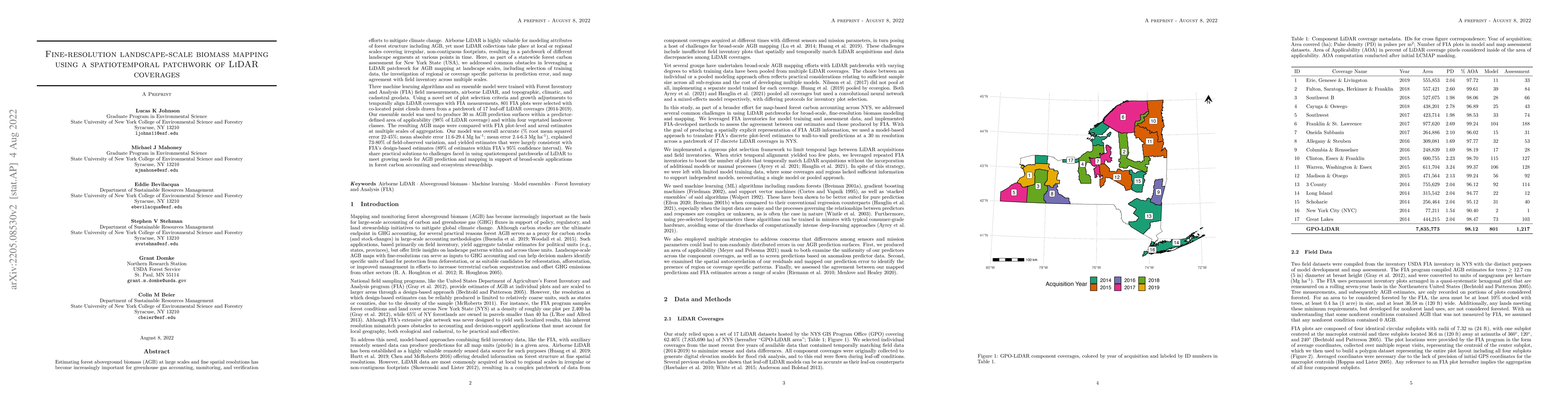
Estimating forest AGB at large scales and fine spatial resolutions has become increasingly important for greenhouse gas accounting, monitoring, and verification efforts to mitigate climate change. Airborne LiDAR is highly valuable for modeling attributes of forest structure including AGB, yet most LiDAR collections take place at local or regional scales covering irregular, non-contiguous footprints, resulting in a patchwork of different landscape segments at various points in time. Here, as part of a statewide forest carbon assessment for New York State (USA), we addressed common obstacles in leveraging a LiDAR patchwork for AGB mapping at landscape scales, including selection of training data, the investigation of regional or coverage specific patterns in prediction error, and map agreement with field inventory across multiple scales. Three machine learning algorithms and an ensemble model were trained with FIA field measurements, airborne LiDAR, and topographic, climatic and cadastral geodata. Using a strict set of plot selection criteria, 801 FIA plots were selected with co-located point clouds drawn from a patchwork of 17 leaf-off LiDAR coverages (2014-2019). Our ensemble model was used to produce 30 m AGB prediction surfaces within a predictor-defined area of applicability (98% of LiDAR coverage), and the resulting AGB maps were compared with FIA plot-level and areal estimates at multiple scales of aggregation. Our model was overall accurate (% RMSE 22-45%; MAE 11.6-29.4 Mg ha$^{-1}$; ME 2.4-6.3 Mg ha$^{-1}$), explained 73-80% of field-observed variation, and yielded estimates that were consistent with FIA's design-based estimates (89% of estimates within FIA's 95% CI). We share practical solutions to challenges faced in using spatiotemporal patchworks of LiDAR to meet growing needs for AGB mapping in support of applications in forest carbon accounting and ecosystem.
AI Key Findings
Get AI-generated insights about this paper's methodology, results, significance, and more — seven facets brought into focus.
Impact
Paper Details
Authors
PDF Preview
Citation Network
Current paper (gray), citations (green), references (blue)
Display is limited for performance on very large graphs.
Discussion 0