Summary
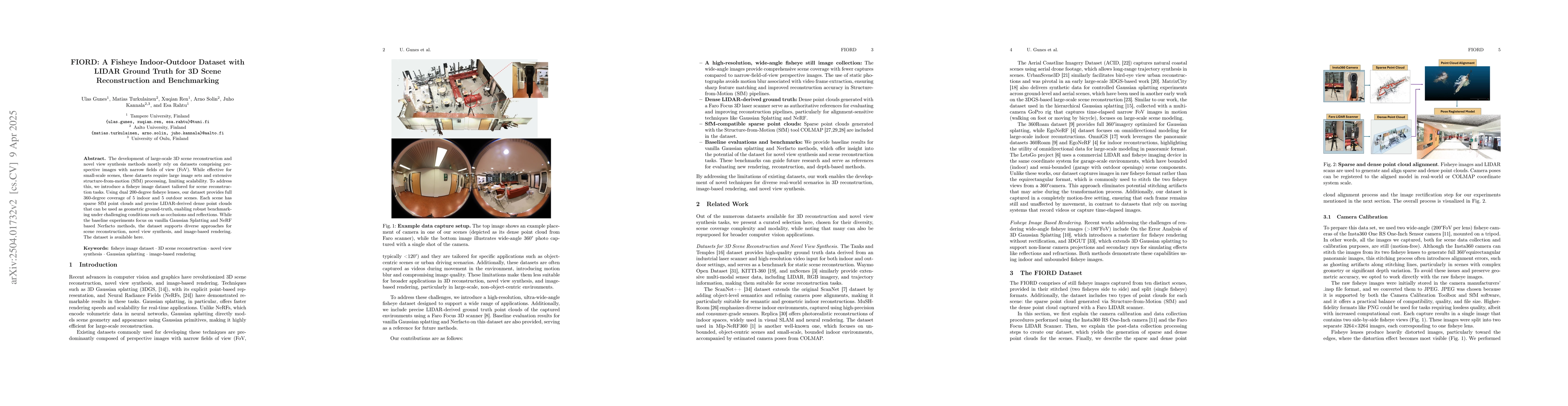
The development of large-scale 3D scene reconstruction and novel view synthesis methods mostly rely on datasets comprising perspective images with narrow fields of view (FoV). While effective for small-scale scenes, these datasets require large image sets and extensive structure-from-motion (SfM) processing, limiting scalability. To address this, we introduce a fisheye image dataset tailored for scene reconstruction tasks. Using dual 200-degree fisheye lenses, our dataset provides full 360-degree coverage of 5 indoor and 5 outdoor scenes. Each scene has sparse SfM point clouds and precise LIDAR-derived dense point clouds that can be used as geometric ground-truth, enabling robust benchmarking under challenging conditions such as occlusions and reflections. While the baseline experiments focus on vanilla Gaussian Splatting and NeRF based Nerfacto methods, the dataset supports diverse approaches for scene reconstruction, novel view synthesis, and image-based rendering.
AI Key Findings
Generated Jun 10, 2025
Methodology
The research introduces FIORD, a fisheye image dataset with 360-degree coverage of 5 indoor and 5 outdoor scenes. It provides sparse SfM point clouds and precise LIDAR-derived dense point clouds for geometric ground-truth, enabling robust benchmarking for scene reconstruction tasks.
Key Results
- FIORD dataset offers full 360-degree coverage using dual 200-degree fisheye lenses.
- Dataset includes sparse SfM point clouds and precise LIDAR-derived dense point clouds as geometric ground-truth.
Significance
This research is important as it addresses the limitations of existing datasets that rely on perspective images with narrow FoV for 3D scene reconstruction, which require large image sets and extensive SfM processing.
Technical Contribution
The main technical contribution is the creation of FIORD, a fisheye image dataset with comprehensive LIDAR ground truth for 3D scene reconstruction and benchmarking.
Novelty
FIORD stands out by providing fisheye images with 360-degree coverage and precise LIDAR ground truth, which is a novel approach compared to existing datasets relying on perspective images with narrow FoVs.
Limitations
- The dataset's baseline experiments focus on vanilla Gaussian Splatting and NeRF-based Nerfacto methods, potentially limiting the evaluation of other reconstruction techniques.
- The fisheye distortion might introduce challenges in some applications not accustomed to this type of imagery.
Future Work
- Explore the application of FIORD dataset with diverse scene reconstruction, novel view synthesis, and image-based rendering methods beyond the baseline experiments.
- Investigate the performance of FIORD in real-time applications and its adaptability to various hardware constraints.
Paper Details
PDF Preview
Citation Network
Current paper (gray), citations (green), references (blue)
Display is limited for performance on very large graphs.
Similar Papers
Found 4 papersThe Newer College Dataset: Handheld LiDAR, Inertial and Vision with Ground Truth
Milad Ramezani, Marco Camurri, Maurice Fallon et al.
GauU-Scene: A Scene Reconstruction Benchmark on Large Scale 3D Reconstruction Dataset Using Gaussian Splatting
Zhen Li, Zhuo Li, Butian Xiong
SS3DM: Benchmarking Street-View Surface Reconstruction with a Synthetic 3D Mesh Dataset
Yubin Hu, Xiaoyang Guo, Yong-Jin Liu et al.
Indoor and Outdoor 3D Scene Graph Generation via Language-Enabled Spatial Ontologies
William Chen, Luca Carlone, Alberto Speranzon et al.
No citations found for this paper.
Comments (0)