FIRETWIN integrates multi-modal sensor data, procedural forest generation, and real-time particle-level fire simulation using Unreal Engine 5, CAWFE fire models, and Google Maps for geospatial visualization.
FIRETWIN: Digital Twin Advancing Multi-Modal Sensing, Interactive Analytics for Wildfire Response
Publication
Metrics
Quick Answers
What methodology did the authors use?
FIRETWIN integrates multi-modal sensor data, procedural forest generation, and real-time particle-level fire simulation using Unreal Engine 5, CAWFE fire models, and Google Maps for geospatial visualization. More in Methodology →
What are the key results?
FIRETWIN successfully reconstructs the 2014 King Fire event with accurate fire progression matching historical data — The system enables real-time, high-fidelity 3D wildfire visualization with over 20,000 fire emitters More in Key Results →
Why is this work significant?
This research advances wildfire management by providing an immersive, interactive digital twin that enhances situational awareness and decision-making through physics-based simulations and multi-sensor integration More in Significance →
What are the main limitations?
Requires high-end hardware for real-time performance — Limited to specific fire models and datasets More in Limitations →
Abstract
Current wildfire management systems lack integrated virtual environments that combine historical data with immersive digital representations, hindering deep analysis and effective decision making. This paper introduces FIRETWIN, a cyber-physical Digital Twin (DT) designed to bridge complex ecological data and operationally relevant, high-fidelity visualizations for actionable incident response. FIRETWIN generates a dynamic 3D virtual globe that visualizes evolving fire behavior in real time, driven by output from physics-based fire models. The system supports multimodal perspectives, including satellite and drone viewpoints comparable to NOAA GOES-18 imagery - enabling comprehensive scenario analysis. Users interact with the environment to assess current fire conditions, anticipate progression, and evaluate available resources. Leveraging Google Maps, Unreal Engine, and pre-generated outputs from the CAWFE 
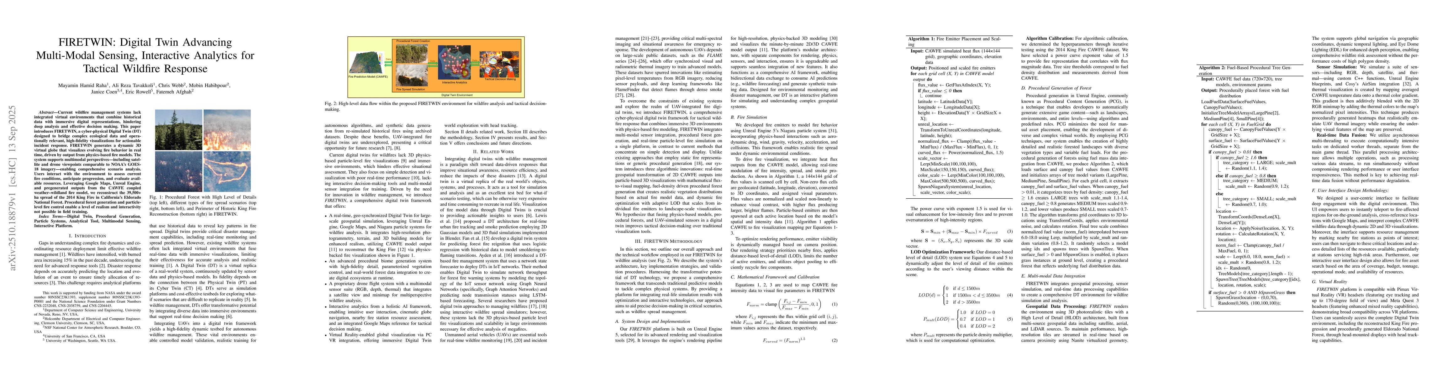
coupled weather-wildland fire model, we reconstruct the spread of the 2014 King Fire in California Eldorado National Forest. Procedural forest generation and particle-level fire control enable a level of realism and interactivity not possible in field training.
Key Findings, in focus
Seven facets of this paper, analysed and brought into focus by AI.
This research advances wildfire management by providing an immersive, interactive digital twin that enhances situational awareness and decision-making through physics-based simulations and multi-sensor integration
- FIRETWIN successfully reconstructs the 2014 King Fire event with accurate fire progression matching historical data
- The system enables real-time, high-fidelity 3D wildfire visualization with over 20,000 fire emitters
- Procedural forest generation creates realistic vegetation distributions based on fuel density data
This research advances wildfire management by providing an immersive, interactive digital twin that enhances situational awareness and decision-making through physics-based simulations and multi-sensor integration
Development of a cyber-physical digital twin framework combining Unreal Engine 5, CAWFE fire models, and procedural generation for wildfire simulation
Introduces three algorithmic innovations: real-time geospatial transformation of CAWFE outputs, fuel-density driven procedural forest generation, and dynamic fire optimization with adaptive LOD
- Requires high-end hardware for real-time performance
- Limited to specific fire models and datasets
- Depends on accurate geospatial data for procedural generation
- Incorporate AI-driven resource allocation models
- Expand sensor calibration validation and security protocols
- Evaluate usability through firefighter training studies
Discussion 0