ArxivLens

Publication

Published: Sep 22, 2025
Categories: q-bio.QM, stat.ML

Metrics

Source: ArXiv

Quick Answers

What methodology did the authors use?

The study employed extreme gradient boosting with Bayesian optimization for tree species classification, integrating Sentinel-1 and Sentinel-2 satellite data, topographic predictors, and field observations from the Swedish National Forest Inventory. More in Methodology →

What are the key results?

The model achieved high accuracy with F1 scores exceeding 0.8 for most species and a strong correlation (0.96) with official forest statistics at the county level. — Entropy-based uncertainty quantified pixel-level classification confidence, highlighting spatial variation in model reliability. More in Key Results →

Why is this work significant?

This research provides a scalable, cost-effective method for producing detailed forest composition maps with uncertainty estimates, supporting biodiversity management, ecological monitoring, and sustainable forest policy. More in Significance →

What are the main limitations?

Pixel-level classification errors may lead to discrepancies in aggregate area estimates due to spectral similarities among broadleaf species. — Spatial resolution limitations may underrepresent sub-canopy species in structurally complex stands. More in Limitations →

Paper Preview

Abstract

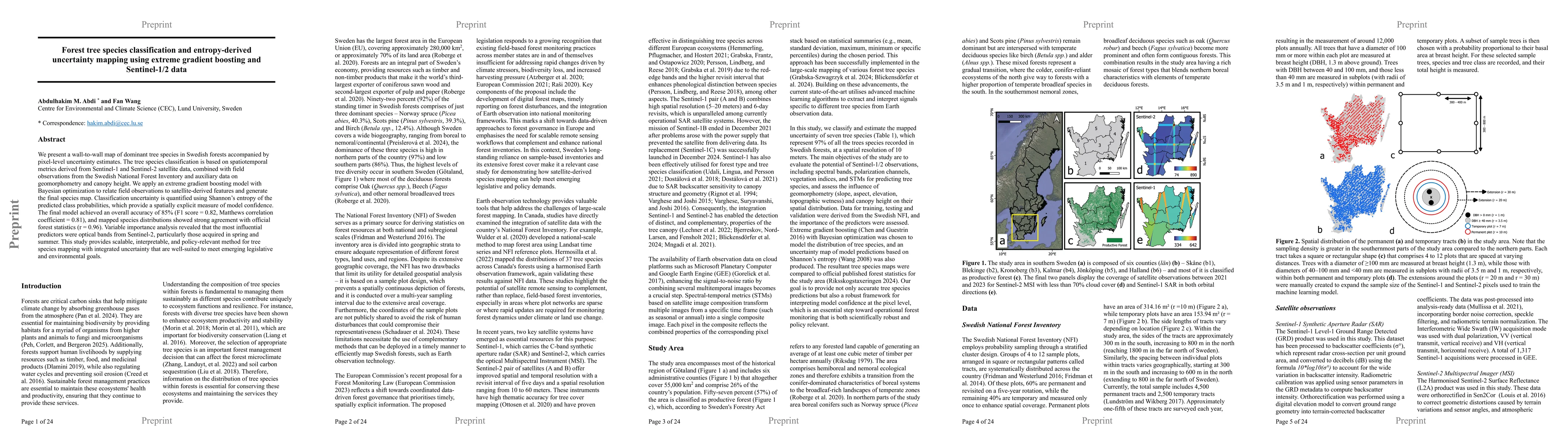
We present a new 10-meter map of dominant tree species in Swedish forests accompanied by pixel-level uncertainty estimates. The tree species classification is based on spatiotemporal metrics derived from Sentinel-1 and Sentinel-2 satellite data, combined with field observations from the Swedish National Forest Inventory. We apply an extreme gradient boosting model with Bayesian optimization to relate field observations to satellite-derived features and generate the final species map. Classification uncertainty is quantified using Shannon's entropy of the predicted class probabilities, which provide a spatially explicit measure of model confidence. The final model achieved an overall accuracy of 85% (F1 score = 0.82, Matthews correlation coefficient = 0.81), and mapped species distributions showed strong agreement with official forest statistics (r = 0.96).

Key Findings, in focus

Seven facets of this paper, analysed and brought into focus by AI.

AI-generated · verify against source Generated Sep 29, 2025
In focus · one-line synthesis

This research provides a scalable, cost-effective method for producing detailed forest composition maps with uncertainty estimates, supporting biodiversity management, ecological monitoring, and sustainable forest policy.

01
MethodologyHow they did it

The study employed extreme gradient boosting with Bayesian optimization for tree species classification, integrating Sentinel-1 and Sentinel-2 satellite data, topographic predictors, and field observations from the Swedish National Forest Inventory.

02
ResultsWhat they found
  • The model achieved high accuracy with F1 scores exceeding 0.8 for most species and a strong correlation (0.96) with official forest statistics at the county level.
  • Entropy-based uncertainty quantified pixel-level classification confidence, highlighting spatial variation in model reliability.
  • Shortwave infrared bands and vegetation indices were most influential, while radar metrics provided complementary structural information.
03
SignificanceWhy it matters

This research provides a scalable, cost-effective method for producing detailed forest composition maps with uncertainty estimates, supporting biodiversity management, ecological monitoring, and sustainable forest policy.

04
Technical ContributionsWhat's new technically

The study introduces a robust framework combining optical, radar, and topographic data with machine learning for large-scale tree species mapping, offering a new approach for operational forest monitoring.

05
NoveltyWhat sets it apart

The integration of entropy-based uncertainty quantification with seasonal spectral analysis represents a novel approach to assessing model reliability in forest classification tasks.

06
LimitationsWhat to be cautious about
  • Pixel-level classification errors may lead to discrepancies in aggregate area estimates due to spectral similarities among broadleaf species.
  • Spatial resolution limitations may underrepresent sub-canopy species in structurally complex stands.
07
Future WorkWhere it goes next
  • Enhancing model performance through integration of higher-resolution LiDAR data for sub-canopy species detection.
  • Expanding the methodology to other regions with different ecological conditions and species compositions.

Paper Details

Paper ID: 2509.18228
Comments: 24 pages, 6 figures, 2 tables
Categories:
q-bio.QM stat.ML

How to Cite This Paper

Reference manager: RIS EndNote


Discussion 0

This website uses cookies to ensure you get the best experience. Learn more