ArxivLens

Publication

Published: Mar 06, 2025
Categories: cs.CV, cs.RO

Metrics

Source: ArXiv

AI Quick Summary

ForestLPR proposes a LiDAR-based place recognition method for natural forests using BEV density images of cross-sectional forest geometry. The method leverages a visual transformer and multi-BEV interaction to adaptively attend to height-specific information, achieving superior performance over state-of-the-art methods in loop closure detection and re-localization.

Quick Answers

What is "ForestLPR: LiDAR Place Recognition in Forests Attentioning Multiple BEV Density Images" about?

ForestLPR proposes a LiDAR-based place recognition method for natural forests using BEV density images of cross-sectional forest geometry. The method leverages a visual transformer and multi-BEV interaction to adaptively attend to height-specific information, achieving superior performance over state-of-the-art methods in loop closure detection and re-localization.

What methodology did the authors use?

The paper proposes ForestLPR, a LiDAR-based place recognition method for natural forests using multiple BEV density images. It employs a visual transformer as a shared backbone to produce local descriptors and introduces a multi-BEV interaction module for adaptive height attention. The method is evaluated on various datasets and compared to state-of-the-art methods. More in Methodology →

What are the key results?

ForestLPR outperforms existing methods with an average increase of 7.38% on Recall@1 for intra-sequence loop closure detection. — The method also shows an average increase of 9.11% on Recall@1 for inter-sequence re-localization compared to the closest competitor. More in Key Results →

Why is this work significant?

This research is significant as it addresses the under-explored problem of LiDAR-based place recognition in natural forest-like environments, which present unique challenges due to high self-similarity and vegetation variations. More in Significance →

What are the main limitations?

The method's performance in dense jungles remains uncertain as it has only been tested on forest-like datasets. — The paper does not extensively discuss the generalizability of the approach to other LiDAR-based tasks beyond place recognition. More in Limitations →

Paper Preview

Abstract

Place recognition is essential to maintain global consistency in large-scale localization systems. While research in urban environments has progressed significantly using LiDARs or cameras, applications in natural forest-like environments remain largely under-explored. Furthermore, forests present particular challenges due to high self-similarity and substantial variations in vegetation growth over time. In this work, we propose a robust LiDAR-based 
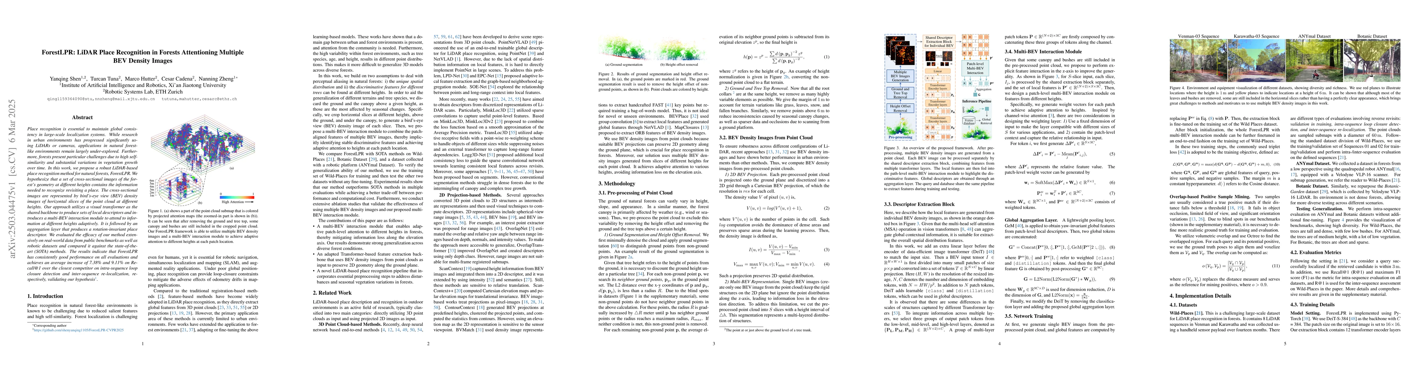
place recognition method for natural forests, ForestLPR. We hypothesize that a set of cross-sectional images of the forest's geometry at different heights contains the information needed to recognize revisiting a place. The cross-sectional images are represented by \ac{bev} density images of horizontal slices of the point cloud at different heights. Our approach utilizes a visual transformer as the shared backbone to produce sets of local descriptors and introduces a multi-BEV interaction module to attend to information at different heights adaptively. It is followed by an aggregation layer that produces a rotation-invariant place descriptor. We evaluated the efficacy of our method extensively on real-world data from public benchmarks as well as robotic datasets and compared it against the state-of-the-art (SOTA) methods. The results indicate that ForestLPR has consistently good performance on all evaluations and achieves an average increase of 7.38\% and 9.11\% on Recall@1 over the closest competitor on intra-sequence loop closure detection and inter-sequence re-localization, respectively, validating our hypothesis

Key Findings, in focus

Seven facets of this paper, analysed and brought into focus by AI.

AI-generated · verify against source Generated Jun 10, 2025
In focus · one-line synthesis

This research is significant as it addresses the under-explored problem of LiDAR-based place recognition in natural forest-like environments, which present unique challenges due to high self-similarity and vegetation variations.

01
MethodologyHow they did it

The paper proposes ForestLPR, a LiDAR-based place recognition method for natural forests using multiple BEV density images. It employs a visual transformer as a shared backbone to produce local descriptors and introduces a multi-BEV interaction module for adaptive height attention. The method is evaluated on various datasets and compared to state-of-the-art methods.

02
ResultsWhat they found
  • ForestLPR outperforms existing methods with an average increase of 7.38% on Recall@1 for intra-sequence loop closure detection.
  • The method also shows an average increase of 9.11% on Recall@1 for inter-sequence re-localization compared to the closest competitor.
  • ForestLPR demonstrates consistent good performance across diverse datasets and scenarios, including different tree growth conditions and forest environments.
  • The approach has a low computational cost, making it suitable for real-time robotics applications.
03
SignificanceWhy it matters

This research is significant as it addresses the under-explored problem of LiDAR-based place recognition in natural forest-like environments, which present unique challenges due to high self-similarity and vegetation variations.

04
Technical ContributionsWhat's new technically

ForestLPR introduces a novel approach to LiDAR-based place recognition in forests by leveraging multiple BEV density images and a multi-BEV interaction module, which adaptively focuses on scene-specific features at different heights.

05
NoveltyWhat sets it apart

The paper's main novelty lies in its application of a visual transformer and multi-BEV interaction module for LiDAR-based place recognition in natural forests, addressing the challenges posed by high self-similarity and vegetation variations.

06
LimitationsWhat to be cautious about
  • The method's performance in dense jungles remains uncertain as it has only been tested on forest-like datasets.
  • The paper does not extensively discuss the generalizability of the approach to other LiDAR-based tasks beyond place recognition.
07
Future WorkWhere it goes next
  • Investigate the method's applicability in dense jungle environments to assess its generalization capabilities.
  • Explore the potential of ForestLPR for other LiDAR-based tasks, such as simultaneous localization and mapping (SLAM).

Impact

61
References

Paper Details

Paper ID: 2503.04475
Comments: accepted by CVPR2025
Categories:
cs.CV cs.RO

How to Cite This Paper

Reference manager: RIS EndNote

Citation Network

Current paper (gray), citations (green), references (blue)

Display is limited for performance on very large graphs.

Current Paper
Citations
References
Click to view

Related Papers

4 found


Discussion 0

This website uses cookies to ensure you get the best experience. Learn more