Freetures: Localization in Signed Distance Function Maps
Publication
Metrics
AI Quick Summary
This research introduces Freetures, a system for robot localization using Signed Distance Function (SDF) maps. Unlike previous methods relying on pointclouds, Freetures extracts features directly from SDFs, capturing both surface geometry and free-space. Evaluations show a 12% average improvement on RGB-D datasets and 18% on LiDAR-based datasets, with successful real-world application in localizing a MAV in a search and rescue environment.
Paper Preview
Abstract
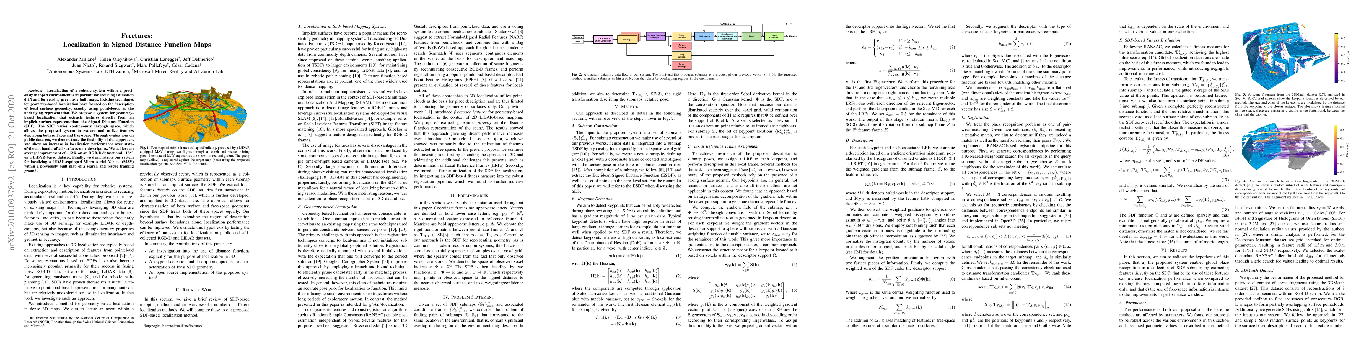
Localization of a robotic system within a previously mapped environment is important for reducing estimation drift and for reusing previously built maps. Existing techniques for geometry-based localization have focused on the description of local surface geometry, usually using pointclouds as the underlying representation. We propose a system for geometry-based localization that extracts features directly from an implicit surface representation: the Signed Distance Function (SDF). The SDF varies continuously through space, which allows the proposed system to extract and utilize features describing both surfaces and free-space. Through evaluations on public datasets, we demonstrate the flexibility of this approach, and show an increase in localization performance over state-of-the-art handcrafted surfaces-only descriptors. We achieve an average improvement of ~12% on an RGB-D dataset and ~18% on a LiDAR-based dataset. Finally, we demonstrate our system for localizing a LiDAR-equipped MAV within a previously built map of a search and rescue training ground.
AI Key Findings
Get AI-generated insights about this paper's methodology, results, significance, and more — seven facets brought into focus.
Impact
Paper Details
Authors
PDF Preview
Key Terms
Citation Network
Current paper (gray), citations (green), references (blue)
Display is limited for performance on very large graphs.
Discussion 0