Summary
Drone-based remote sensing combined with AI-driven methodologies has shown great potential for accurate mapping and monitoring of coral reef ecosystems. This study presents a novel multi-scale approach to coral reef monitoring, integrating fine-scale underwater imagery with medium-scale aerial imagery. Underwater images are captured using an Autonomous Surface Vehicle (ASV), while aerial images are acquired with an aerial drone. A transformer-based deep-learning model is trained on underwater images to detect the presence of 31 classes covering various coral morphotypes, associated fauna, and habitats. These predictions serve as annotations for training a second model applied to aerial images. The transfer of information across scales is achieved through a weighted footprint method that accounts for partial overlaps between underwater image footprints and aerial image tiles. The results show that the multi-scale methodology successfully extends fine-scale classification to larger reef areas, achieving a high degree of accuracy in predicting coral morphotypes and associated habitats. The method showed a strong alignment between underwater-derived annotations and ground truth data, reflected by an AUC (Area Under the Curve) score of 0.9251. This shows that the integration of underwater and aerial imagery, supported by deep-learning models, can facilitate scalable and accurate reef assessments. This study demonstrates the potential of combining multi-scale imaging and AI to facilitate the monitoring and conservation of coral reefs. Our approach leverages the strengths of underwater and aerial imagery, ensuring the precision of fine-scale analysis while extending it to cover a broader reef area.
AI Key Findings
Generated Jun 11, 2025
Methodology
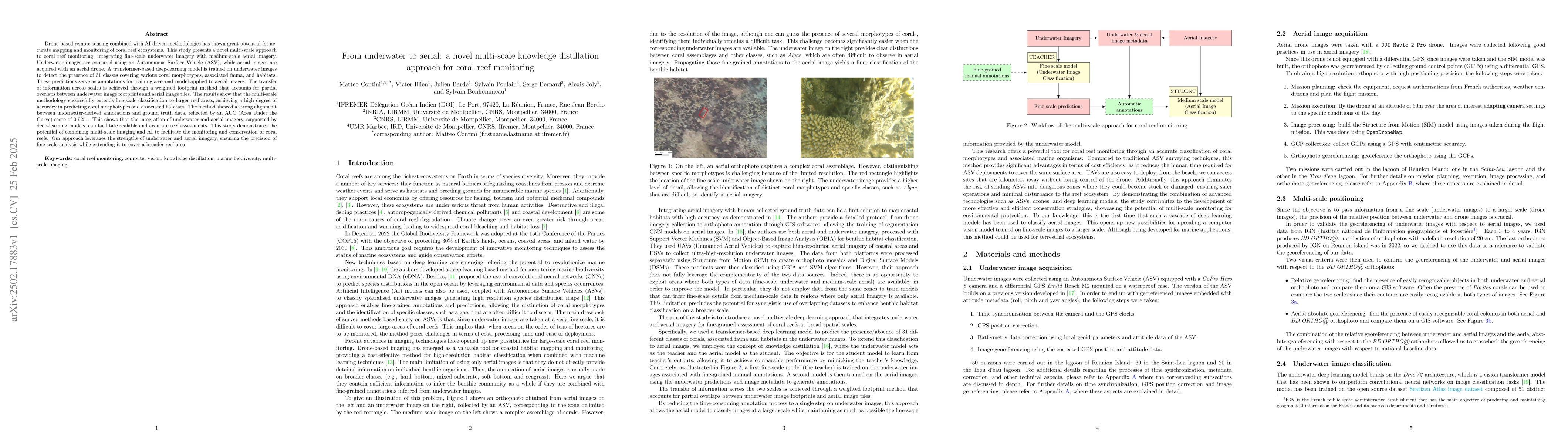
The study integrates underwater imagery from an Autonomous Surface Vehicle (ASV) with medium-scale aerial imagery from a drone. A transformer-based deep-learning model is trained on underwater images for detecting 31 classes of coral morphotypes, fauna, and habitats. These predictions annotate aerial images for training a second model, with information transfer across scales achieved via a weighted footprint method.
Key Results
- The multi-scale methodology successfully extends fine-scale classification to larger reef areas.
- High accuracy in predicting coral morphotypes and associated habitats was achieved with an AUC score of 0.9251.
- Strong alignment between underwater-derived annotations and ground truth data was demonstrated.
Significance
This research shows the potential of combining multi-scale imaging and AI for scalable and accurate coral reef assessments, facilitating their monitoring and conservation.
Technical Contribution
The novel multi-scale knowledge distillation approach using a transformer-based deep-learning model for coral reef monitoring, combining underwater and aerial imagery.
Novelty
This work introduces a unique methodology that bridges fine-scale underwater imagery with medium-scale aerial imagery for coral reef monitoring, leveraging AI to extend precision across broader reef areas.
Limitations
- The paper does not discuss limitations explicitly, but potential limitations could include the reliance on specific imaging technologies and the need for extensive annotated underwater imagery.
- Generalizability to diverse reef environments and conditions might require further investigation.
Future Work
- Exploring the application of this methodology in various reef ecosystems and environmental conditions.
- Investigating the integration of additional data sources (e.g., water quality parameters) to enhance predictive models.
Paper Details
PDF Preview
Citation Network
Current paper (gray), citations (green), references (blue)
Display is limited for performance on very large graphs.
Similar Papers
Found 4 papersAutomatic Coral Detection with YOLO: A Deep Learning Approach for Efficient and Accurate Coral Reef Monitoring
Ouassine Younes, Zahir Jihad, Conruyt Noël et al.
EBA-AI: Ethics-Guided Bias-Aware AI for Efficient Underwater Image Enhancement and Coral Reef Monitoring
Irfan Hussain, Lyes Saad Saoud
CoralVQA: A Large-Scale Visual Question Answering Dataset for Coral Reef Image Understanding
Wei Wang, Mingjie Li, Yi Wang et al.
No citations found for this paper.
Comments (0)