FUSE defines a unified state-estimation framework that exposes four interface roles—observation ingestion, propagation, update, and state query—to decouple temporal processing, local geometric association, estimator formulation, and map-update policy. A LiDAR–IMU instantiation demonstrates mixed-rate sensing and degeneracy handling, where high-rate inertial propagation, LiDAR-triggered geometric updates, residual screening, and degeneracy-aware correction operate through the same interface boundaries.
FUSE: A Framework for Unified State Estimation in Robotic SLAM Systems
Publication
Metrics
AI Quick Summary
FUSE proposes a unified interface for state estimation in SLAM to decouple timing, geometry, estimation, and mapping decisions. An implemented LiDAR–IMU system shows improved trajectory accuracy (1.626 m on a 418 m loop, 7.9% better than Faster-LIO) by coordinating high-rate propagation, geometry updates, and degeneracy-aware corrections within the same framework.
Quick Answers
What is "FUSE: A Framework for Unified State Estimation in Robotic SLAM Systems" about?
FUSE proposes a unified interface for state estimation in SLAM to decouple timing, geometry, estimation, and mapping decisions. An implemented LiDAR–IMU system shows improved trajectory accuracy (1.626 m on a 418 m loop, 7.9% better than Faster-LIO) by coordinating high-rate propagation, geometry updates, and degeneracy-aware corrections within the same framework.
What methodology did the authors use?
FUSE defines a unified state-estimation framework that exposes four interface roles—observation ingestion, propagation, update, and state query—to decouple temporal processing, local geometric association, estimator formulation, and map-update policy. A LiDAR–IMU instantiation demonstrates mixed-rate sensing and degeneracy handling, where high-rate inertial propagation, LiDAR-triggered geometric updates, residual screening, and degeneracy-aware correction operate through the same interface boundaries. More in Methodology →
What are the key results?
On a 418 m loop corridor sequence, the LiDAR–IMU instantiation achieves 1.626 m end-to-end trajectory error, representing a 7.9% relative error reduction versus Faster-LIO, the best non-FUSE baseline on this sequence. — Ablation studies and runtime measurements indicate residual screening, degeneracy-aware updates, and covariance propagation contribute to improved corridor performance and stability. More in Key Results →
Why is this work significant?
Demonstrates that decoupling estimation primitives into shared interfaces enables consistent handling of temporal history, residual-based local associations, and map persistence across backends, potentially improving robustness in mixed-rate SLAM systems and offering a path to systematic comparisons across estimators and sensors. More in Significance →
What are the main limitations?
Evaluation centers on a LiDAR–IMU instance; broad generalization to other backends and sensor combinations remains to be demonstrated. — The study focuses on a single diagnostic corridor sequence, with limited exploration of full closed-loop deployments and long-term map stability. More in Limitations →
Abstract
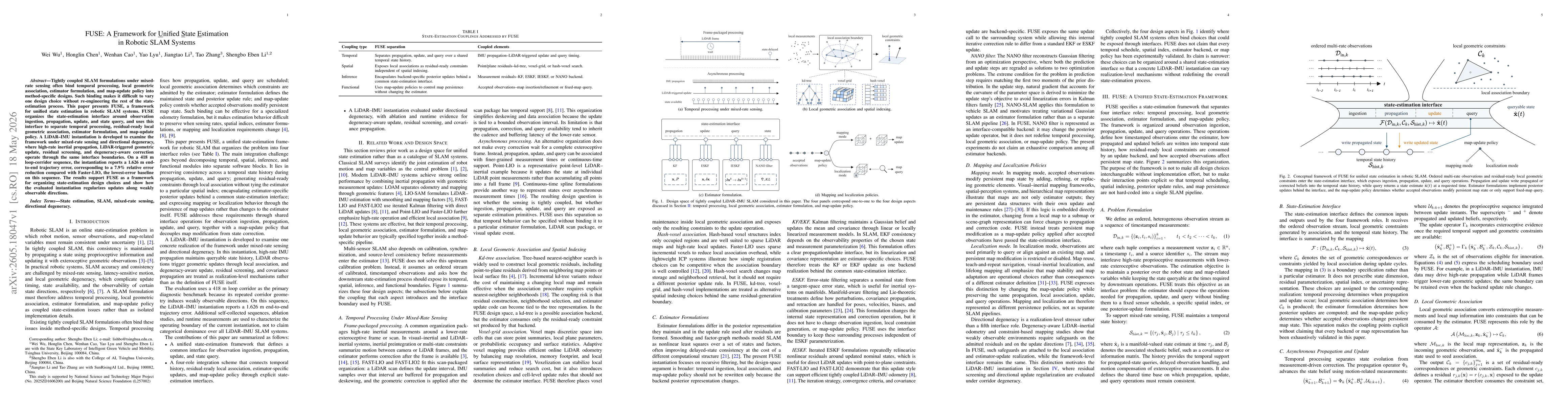
Tightly coupled SLAM formulations under mixed-rate sensing often bind temporal processing, local geometric association, estimator formulation, and map-update policy into method-specific designs. Such binding makes it difficult to vary one design choice without re-engineering the rest of the state-estimation process. This paper presents FUSE, a framework for unified state estimation in robotic SLAM systems. FUSE organizes the state-estimation interface around observation ingestion, propagation, update, and state query, and uses this interface to separate temporal processing, residual-ready local geometric association, estimator formulation, and map-update policy. A LiDAR--IMU instantiation is developed to examine the framework under mixed-rate sensing and directional degeneracy, where high-rate inertial propagation, LiDAR-triggered geometric update, residual screening, and degeneracy-aware correction operate through the same interface boundaries. On a 418 m loop-corridor sequence, the instantiation reports a 1.626~m end-to-end trajectory error, corresponding to a 7.9% relative error reduction compared with Faster-LIO, the lowest-error baseline on this sequence. The results support FUSE as a framework for organizing state-estimation design choices and show how the evaluated instantiation regularizes updates along weakly observable directions.
Key Findings, in focus
Seven facets of this paper, analysed and brought into focus by AI.
Demonstrates that decoupling estimation primitives into shared interfaces enables consistent handling of temporal history, residual-based local associations, and map persistence across backends, potentially improving robustness in mixed-rate SLAM systems and offering a path to systematic comparisons across estimators and sensors.
- On a 418 m loop corridor sequence, the LiDAR–IMU instantiation achieves 1.626 m end-to-end trajectory error, representing a 7.9% relative error reduction versus Faster-LIO, the best non-FUSE baseline on this sequence.
- Ablation studies and runtime measurements indicate residual screening, degeneracy-aware updates, and covariance propagation contribute to improved corridor performance and stability.
- The results support FUSE as a framework for organizing state-estimation design choices and show how the evaluated instantiation regularizes updates along weakly observable directions.
Demonstrates that decoupling estimation primitives into shared interfaces enables consistent handling of temporal history, residual-based local associations, and map persistence across backends, potentially improving robustness in mixed-rate SLAM systems and offering a path to systematic comparisons across estimators and sensors.
Proposes a unified state-estimation interface architecture that decouples observation ingestion, propagation, update, and state query from map-update policy, enabling residual-ready local geometry and estimator updates to be composed independently; provides a LiDAR–IMU instantiation that demonstrates degenerate-direction handling and mixed-rate processing within this interface.
Introduces a four-role integration framework that explicitly separates temporal history management, residual-ready local association, estimator-specific posterior updates, and map persistence policies, enabling flexible composition across backends and sensing configurations in SLAM systems.
- Evaluation centers on a LiDAR–IMU instance; broad generalization to other backends and sensor combinations remains to be demonstrated.
- The study focuses on a single diagnostic corridor sequence, with limited exploration of full closed-loop deployments and long-term map stability.
- Ablations cover selected components; comprehensive analysis across all possible interface configurations and timing scenarios is still needed.
- Extend evaluation to additional estimator backends, spatial indexes, and sensor modalities to validate framework generality.
- Investigate closed-loop deployments to assess end-to-end control implications and real-time constraints under diverse operating conditions.
- Develop standardized benchmarks within FUSE to facilitate cross-system comparisons and reproducibility.
Discussion 0