ArxivLens

Publication

Published: Dec 22, 2025
Categories: cs.CV

Metrics

Source: ArXiv

Quick Answers

What methodology did the authors use?

The research employs a multi-spectral satellite imagery analysis approach, combining Thermal Infrared (TIR) and Short Wave Infrared (SWIR) data with deep learning architectures like DGCNN and FusionNet. It uses ablation studies, transfer learning experiments, and performance comparisons against SOTA models to evaluate effectiveness. More in Methodology →

What are the key results?

FusionNet achieves 90.6% accuracy using SWIR Band7:6 ratio, outperforming RGB-pretrained models — DGCNN backbone shows 88.7% accuracy on SWIR ratio dataset with synergistic architectural components More in Key Results →

Why is this work significant?

This work advances industrial infrastructure mapping using multispectral satellite data, offering improved detection of cement plants with physical priors for environmental monitoring and emissions tracking More in Significance →

What are the main limitations?

Limited dataset size affects transfer learning effectiveness — RGB-TIR domain gap challenges pretrained model adaptation More in Limitations →

Paper Preview

Abstract

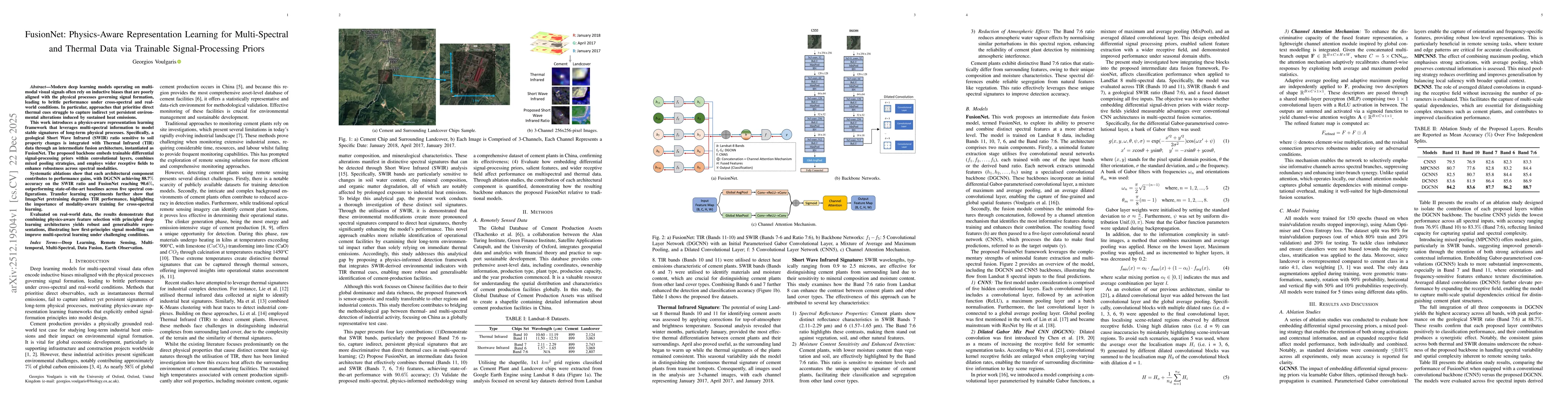
Modern deep learning models operating on multi-modal visual signals often rely on inductive biases that are poorly aligned with the physical processes governing signal formation, leading to brittle performance under cross-spectral and real-world conditions. In particular, approaches that prioritise direct thermal cues struggle to capture indirect yet persistent environmental alterations induced by sustained heat emissions. This work introduces a physics-aware representation learning framework that leverages multi-spectral information to model stable signatures of long-term physical processes. Specifically, a geological Short Wave Infrared (SWIR) ratio sensitive to soil property changes is integrated with Thermal Infrared (TIR) data through an intermediate fusion architecture, instantiated as FusionNet. The proposed backbone embeds trainable differential signal-processing priors within convolutional layers, combines mixed pooling strategies, and employs wider receptive fields to enhance robustness across spectral modalities. Systematic ablations show that each architectural component contributes to performance gains, with DGCNN achieving 88.7% accuracy on the SWIR ratio and FusionNet reaching 90.6%, outperforming state-of-the-art baselines across five spectral configurations. Transfer learning experiments further show that ImageNet pretraining degrades TIR performance, highlighting the importance of modality-aware training for cross-spectral learning. Evaluated on real-world data, the results demonstrate that combining physics-aware feature selection with principled deep learning architectures yields robust and generalisable representations, illustrating how first-principles signal modelling can improve multi-spectral learning under challenging conditions.

Key Findings, in focus

Seven facets of this paper, analysed and brought into focus by AI.

AI-generated · verify against source Generated Dec 23, 2025
In focus · one-line synthesis

This work advances industrial infrastructure mapping using multispectral satellite data, offering improved detection of cement plants with physical priors for environmental monitoring and emissions tracking

01
MethodologyHow they did it

The research employs a multi-spectral satellite imagery analysis approach, combining Thermal Infrared (TIR) and Short Wave Infrared (SWIR) data with deep learning architectures like DGCNN and FusionNet. It uses ablation studies, transfer learning experiments, and performance comparisons against SOTA models to evaluate effectiveness.

02
ResultsWhat they found
  • FusionNet achieves 90.6% accuracy using SWIR Band7:6 ratio, outperforming RGB-pretrained models
  • DGCNN backbone shows 88.7% accuracy on SWIR ratio dataset with synergistic architectural components
  • SWIR bands outperform TIR in distinguishing cement plants from land cover
03
SignificanceWhy it matters

This work advances industrial infrastructure mapping using multispectral satellite data, offering improved detection of cement plants with physical priors for environmental monitoring and emissions tracking

04
Technical ContributionsWhat's new technically

Development of DGCNN architecture with trainabledifferential Gabor convolutions, mixed pooling strategies, and physics-informed fusion framework

05
NoveltyWhat sets it apart

Integration of physical signal priors with deep learning for cross-spectral analysis, combined with intermediate fusion of TIR and SWIR data for enhanced feature extraction

06
LimitationsWhat to be cautious about
  • Limited dataset size affects transfer learning effectiveness
  • RGB-TIR domain gap challenges pretrained model adaptation
07
Future WorkWhere it goes next
  • Exploring physics-informed band selection for other industrial targets
  • Investigating domain adaptation techniques for cross-spectral learning

Paper Details

Paper ID: 2512.19504
Comments: Preprint. Under review at IEEE Journal of Selected Topics in Applied Earth Observations and Remote Sensing (JSTARS)
Categories:
cs.CV

How to Cite This Paper

Reference manager: RIS EndNote


Discussion 0

This website uses cookies to ensure you get the best experience. Learn more