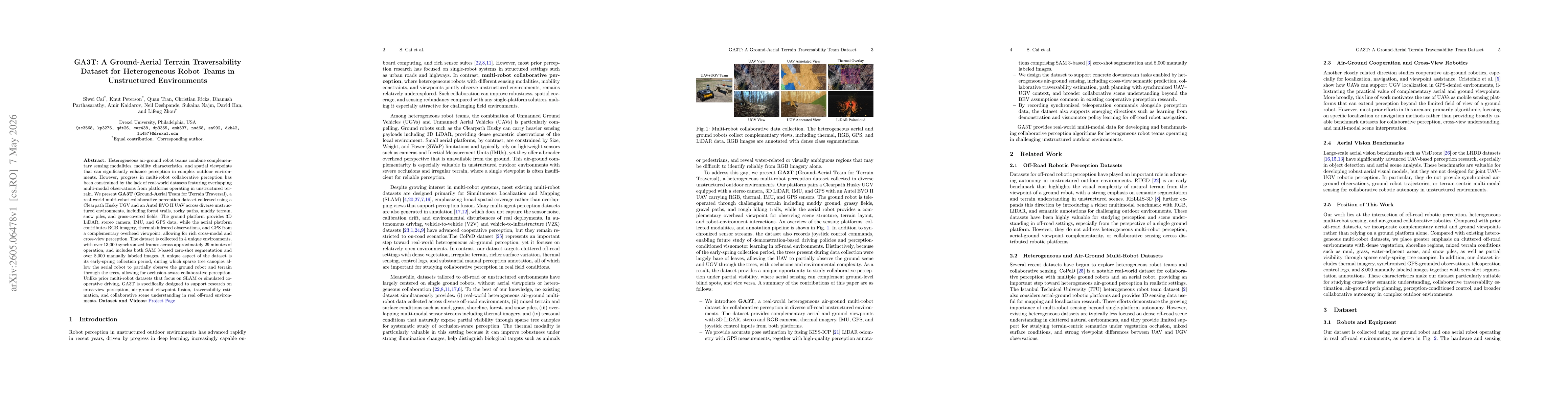
GA3T was collected from real-world, heterogeneous air-ground robot teams (Clearpath Husky UGV and Autel EVO II UAV) across four unstructured environments, capturing overlapping multi-modal streams (3D LiDAR, stereo camera, IMU, GPS on ground; RGB, thermal/infrared, GPS on aerial) to study cross-view perception, air-ground fusion, traversability estimation, and collaborative scene understanding. The dataset includes synchronized frames (~13,000) over ~29 minutes, with both SAM3-based zero-shot segmentation and >8,000 manually labeled images, enabling occlusion-aware collaboration via partial aerial ground visibility through sparse spring canopies. Emphasis is placed on real-world factors such as sensor noise, calibration drift, and environmental disturbances not present in simulations, to support cross-modal and cross-view perception research in off-road conditions.
GA3T: A Ground-Aerial Terrain Traversability Dataset for Heterogeneous Robot Teams in Unstructured Environments
Publication
Metrics
Quick Answers
What methodology did the authors use?
GA3T was collected from real-world, heterogeneous air-ground robot teams (Clearpath Husky UGV and Autel EVO II UAV) across four unstructured environments, capturing overlapping multi-modal streams (3D LiDAR, stereo camera, IMU, GPS on ground; RGB, thermal/infrared, GPS on aerial) to study cross-view perception, air-ground fusion, traversability estimation, and collaborative scene understanding. The dataset includes synchronized frames (~13,000) over ~29 minutes, with... More in Methodology →
What are the key results?
GA3T provides real-world, heterogeneous air-ground multi-robot data with overlapping modalities, enabling cross-view perception and fusion research in unstructured terrains. — The dataset includes substantial manual annotations and segmentation labels, facilitating benchmarking for traversability estimation and collaborative scene understanding. More in Key Results →
Why is this work significant?
GA3T addresses a gap in real-world datasets by combining ground and aerial perspectives, multi-modal sensors, and varied off-road environments to advance robust cross-view perception, traversability estimation, and collaborative perception in challenging terrains. More in Significance →
What are the main limitations?
Data collection spans four environments and ~29 minutes, which may limit diversity for some rare terrain conditions. — Seasonal and weather variations beyond early spring (e.g., dense foliage, heavy snow) are not represented, potentially constraining generalization. More in Limitations →
Paper Preview
Abstract
Heterogeneous air-ground robot teams combine complementary sensing modalities, mobility characteristics, and spatial viewpoints that can significantly enhance perception in complex outdoor environments. However, progress in multi-robot collaborative perception has been constrained by the lack of real-world datasets featuring overlapping multi-modal observations from platforms operating in unstructured terrain. We present GA3T (Ground-Aerial Team for Terrain Traversal), a real-world multi-robot collaborative perception dataset collected using a Clearpath Husky UGV and an Autel EVO~II UAV across diverse unstructured environments, including forest trails, rocky paths, muddy terrain, snow piles, and grass-covered fields. The ground platform provides 3D LiDAR, stereo camera, IMU, and GPS data, while the aerial platform contributes RGB imagery, thermal/infrared observations, and GPS from a complementary overhead viewpoint, allowing for rich cross-modal and cross-view perception. The dataset is collected in 4 unique environments, with over 13,000 synchronized frames across approximately 29 minutes of operation, and includes both SAM~3-based zero-shot segmentation and over 8,000 manually labeled images. A unique aspect of the dataset is its early-spring collection period, during which sparse tree canopies allow the aerial robot to partially observe the ground robot and terrain through the trees, allowing for occlusion-aware collaborative perception. Unlike prior multi-robot datasets that focus on SLAM or simulated cooperative driving, GA3T is specifically designed to support research on cross-view perception, air-ground viewpoint fusion, traversability estimation, and collaborative scene understanding in real off-road environments.
Key Findings, in focus
Seven facets of this paper, analysed and brought into focus by AI.
GA3T addresses a gap in real-world datasets by combining ground and aerial perspectives, multi-modal sensors, and varied off-road environments to advance robust cross-view perception, traversability estimation, and collaborative perception in challenging terrains.
- GA3T provides real-world, heterogeneous air-ground multi-robot data with overlapping modalities, enabling cross-view perception and fusion research in unstructured terrains.
- The dataset includes substantial manual annotations and segmentation labels, facilitating benchmarking for traversability estimation and collaborative scene understanding.
- Early-spring collection with partial occlusion from sparse canopies enables study of occlusion-aware perception and occlusion handling strategies.
GA3T addresses a gap in real-world datasets by combining ground and aerial perspectives, multi-modal sensors, and varied off-road environments to advance robust cross-view perception, traversability estimation, and collaborative perception in challenging terrains.
Introduction of GA3T, a real-world ground-aerial traversability dataset with synchronized multi-modal streams, manual annotations, and occlusion-aware scenarios designed to support cross-view perception and collaborative understanding in unstructured off-road environments.
First real-world dataset to jointly provide heterogeneous air-ground data, overlapping multi-modal streams including thermal imaging, across diverse off-road environments with occlusion-aware setups enabled by early-spring canopy conditions, focusing on cross-view perception and traversability rather than SLAM alone.
- Data collection spans four environments and ~29 minutes, which may limit diversity for some rare terrain conditions.
- Seasonal and weather variations beyond early spring (e.g., dense foliage, heavy snow) are not represented, potentially constraining generalization.
- Expand dataset to include additional seasons and weather conditions to broaden occlusion and modality fusion scenarios.
- Develop standardized benchmarks for cross-view perception and traversability estimation using GA3T annotations.
- Investigate learning algorithms robust to partial visibility and sensor noise using the provided multi-modal sequences.
Discussion 0