Publication
Metrics
AI Quick Summary
This paper proposes a series strategy of generators for multi-scale remote sensing image to map translation using GANs, addressing inconsistencies and high computation costs. The method generates high-quality multi-scale maps with improved structural similarity and intersection over union metrics.
Paper Preview
Abstract
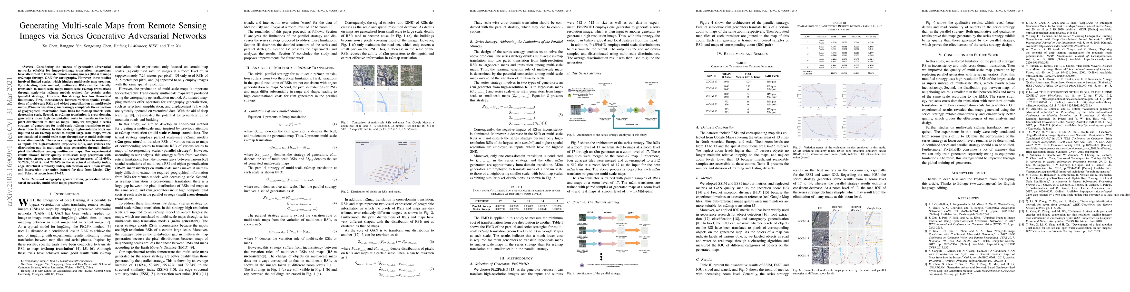
Considering the success of generative adversarial networks (GANs) for image-to-image translation, researchers have attempted to translate remote sensing images (RSIs) to maps (rs2map) through GAN for cartography. However, these studies involved limited scales, which hinders multi-scale map creation. By extending their method, multi-scale RSIs can be trivially translated to multi-scale maps (multi-scale rs2map translation) through scale-wise rs2map models trained for certain scales (parallel strategy). However, this strategy has two theoretical limitations. First, inconsistency between various spatial resolutions of multi-scale RSIs and object generalization on multi-scale maps (RS-m inconsistency) increasingly complicate the extraction of geographical information from RSIs for rs2map models with decreasing scale. Second, as rs2map translation is cross-domain, generators incur high computation costs to transform the RSI pixel distribution to that on maps. Thus, we designed a series strategy of generators for multi-scale rs2map translation to address these limitations. In this strategy, high-resolution RSIs are inputted to an rs2map model to output large-scale maps, which are translated to multi-scale maps through series multi-scale map translation models. The series strategy avoids RS-m inconsistency as inputs are high-resolution large-scale RSIs, and reduces the distribution gap in multi-scale map generation through similar pixel distributions among multi-scale maps. Our experimental results showed better quality multi-scale map generation with the series strategy, as shown by average increases of 11.69%, 53.78%, 55.42%, and 72.34% in the structural similarity index, edge structural similarity index, intersection over union (road), and intersection over union (water) for data from Mexico City and Tokyo at zoom level 17-13.
AI Key Findings
Get AI-generated insights about this paper's methodology, results, significance, and more — seven facets brought into focus.
Impact
Paper Details
Authors
PDF Preview
Key Terms
Citation Network
Current paper (gray), citations (green), references (blue)
Display is limited for performance on very large graphs.
Discussion 0