Summary

We introduce Geo-R1, a reasoning-centric post-training framework that unlocks geospatial reasoning in vision-language models by combining thinking scaffolding and elevating. In the scaffolding stage, Geo-R1 instills a ``geospatial thinking paradigm" via supervised fine-tuning on synthetic chain-of-thought exemplars, enabling models to connect visual cues with geographic priors without costly human reasoning annotations. In the elevating stage, it uses GRPO-based reinforcement learning on a weakly-supervised cross-view pairing proxy. This design supplies a verifiable and scalable reward signal: teaching models to capture and reconcile features across modalities, and harnessing reasoning for accurate prediction. Geo-R1 extends geospatial modeling from domain pretraining / supervised finetuning to reasoning-first post-training, and achieves state-of-the-art performance across various geospatial reasoning benchmarks. Our model is available at https://huggingface.co/miniHui/Geo-R1.

AI Key Findings

Generated Oct 05, 2025

Methodology

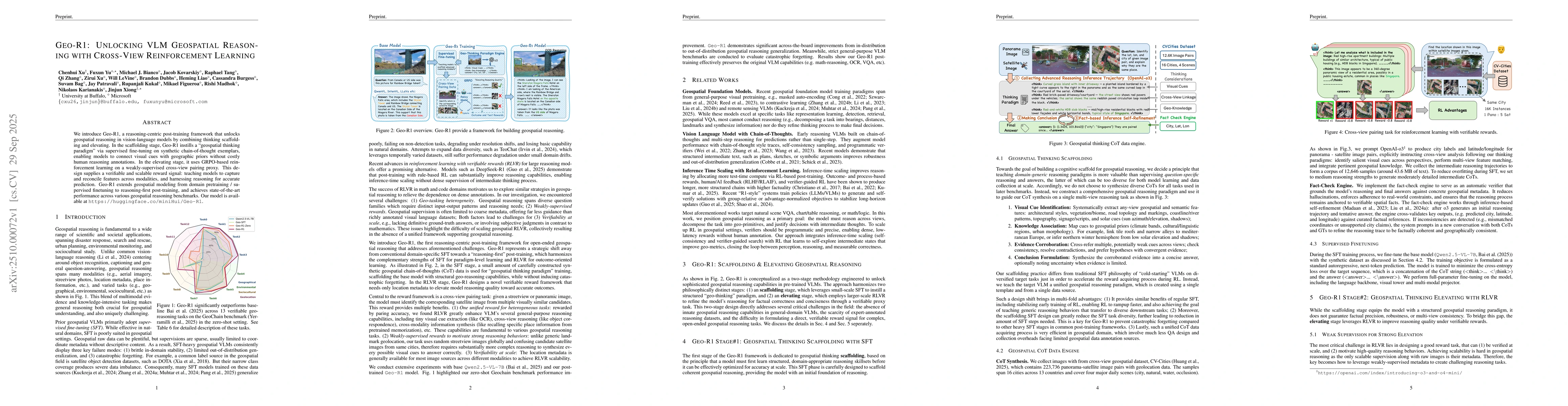
The research employs a multimodal large language model (LLM) enhanced with spatial reasoning capabilities, utilizing a combination of reinforcement learning from human feedback (RLHF), self-supervised pre-training, and fine-tuning on specialized datasets for geospatial tasks. The model is optimized using Grouped Knowledge Distillation (GKD) and evaluated across various benchmarks including Geo-R1, MEGA-Bench, MMMU, and GPQA.

Key Results

  • The Geo-R1 model achieves state-of-the-art performance on geospatial reasoning tasks, outperforming both open-source and commercial models in benchmarks like IMAGEO-GSS and IMAGEO-UPC.
  • The model demonstrates strong capabilities in commonsense reasoning, domain-specific knowledge, and multi-modal understanding across diverse tasks such as object recognition, scene understanding, and logical reasoning.
  • The post-training process preserves the base model's original capabilities while enhancing spatial and temporal reasoning, as evidenced by improved accuracy and reduced error margins in geolocation tasks.

Significance

This research advances the field of geospatial AI by developing a robust model capable of handling complex spatial reasoning tasks, with potential applications in navigation, urban planning, and environmental monitoring. The methodology provides a framework for improving multimodal understanding in real-world scenarios.

Technical Contribution

The paper introduces a novel training framework combining RLHF, self-supervised learning, and GKD for enhancing spatial reasoning in LLMs, along with a comprehensive evaluation across multiple benchmarks to validate the model's capabilities.

Novelty

This work introduces a specialized geospatial reasoning model with enhanced spatial and temporal understanding, combined with a rigorous evaluation across diverse benchmarks, making it distinct from general-purpose LLMs.

Limitations

  • The model's performance is heavily dependent on the quality and diversity of the training data, which may limit its generalizability to unseen or niche geospatial scenarios.
  • The computational resources required for training and fine-tuning may pose challenges for widespread adoption in resource-constrained environments.

Future Work

  • Exploring the integration of real-time geospatial data for dynamic environment understanding.
  • Investigating the use of model compression techniques to reduce computational overhead without sacrificing performance.
  • Expanding the model's capabilities to handle additional modalities such as 3D spatial data and satellite imagery.

Paper Details

PDF Preview

Download PDF

Comments (0)

This website uses cookies to ensure you get the best experience. Learn more