ArxivLens

Publication

Published: Sep 07, 2025
Categories: cs.SE, cs.AI, I.2

Metrics

Source: ArXiv

Quick Answers

What methodology did the authors use?

The study evaluated the performance of large language models (LLMs) in geospatial tasks through benchmarking against existing datasets and tasks, analyzing their capabilities in spatial reasoning, code generation, and question-answering. More in Methodology →

What are the key results?

LLMs demonstrate strong performance in geospatial reasoning and code generation but struggle with complex spatial queries. — Specialized training data significantly improves model performance on domain-specific tasks. More in Key Results →

Why is this work significant?

This research advances the application of LLMs in geospatial domains, enabling more accurate analysis, automation of geoprocessing tasks, and better support for geographic knowledge discovery. More in Significance →

What are the main limitations?

Current benchmarks lack comprehensive coverage of real-world geospatial scenarios — Models show inconsistent performance across different spatial reasoning tasks More in Limitations →

Paper Preview

Abstract

Recent advances in large language models (LLMs) have fueled growing interest in automating geospatial analysis and GIS workflows, yet their actual capabilities remain uncertain. In this work, we call for rigorous evaluation of LLMs on well-defined geoprocessing tasks before making claims about full GIS automation. To this end, we present GeoAnalystBench, a benchmark of 50 Python-based tasks derived from real-world geospatial problems and carefully validated by GIS experts. Each task is paired with a minimum deliverable product, and evaluation covers workflow validity, structural alignment, semantic similarity, and code quality (CodeBLEU). Using this benchmark, we assess both proprietary and open source models. Results reveal a clear gap: proprietary models such as ChatGPT-4o-mini achieve high validity 95% and stronger code alignment (CodeBLEU 0.39), while smaller open source models like DeepSeek-R1-7B often generate incomplete or inconsistent workflows (48.5% validity, 0.272 CodeBLEU). Tasks requiring deeper spatial reasoning, such as spatial relationship detection or optimal site selection, remain the most challenging across all models. These findings demonstrate both the promise and limitations of current LLMs in GIS automation and provide a reproducible framework to advance GeoAI research with human-in-the-loop support.
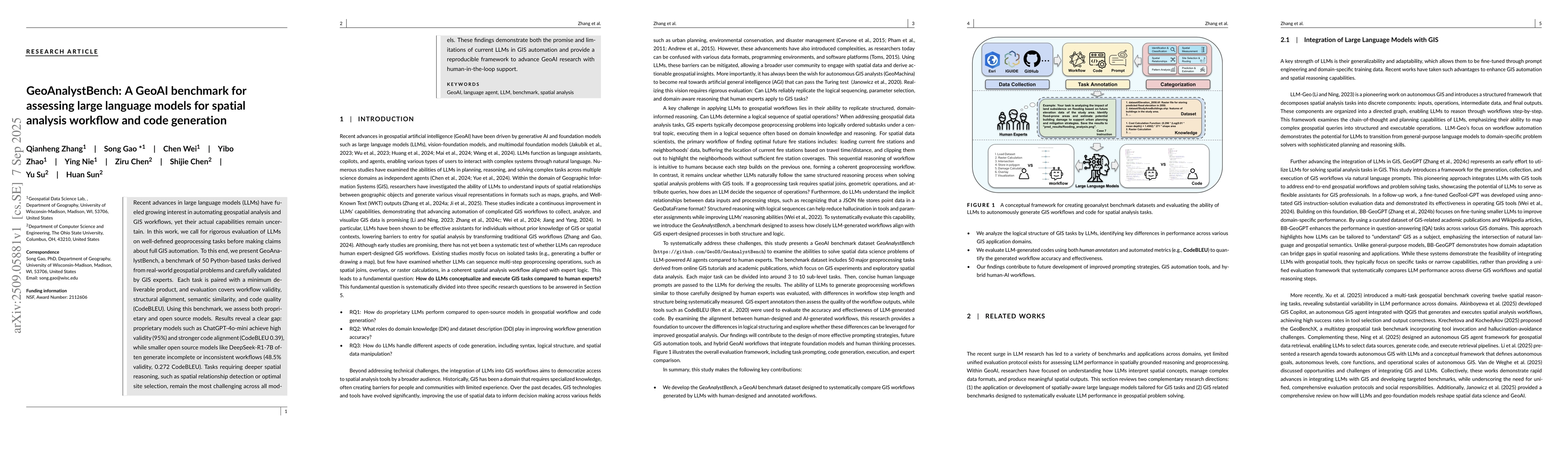
Key Findings, in focus

Seven facets of this paper, analysed and brought into focus by AI.

AI-generated · verify against source Generated Nov 19, 2025
In focus · one-line synthesis

This research advances the application of LLMs in geospatial domains, enabling more accurate analysis, automation of geoprocessing tasks, and better support for geographic knowledge discovery.

01
MethodologyHow they did it

The study evaluated the performance of large language models (LLMs) in geospatial tasks through benchmarking against existing datasets and tasks, analyzing their capabilities in spatial reasoning, code generation, and question-answering.

02
ResultsWhat they found
  • LLMs demonstrate strong performance in geospatial reasoning and code generation but struggle with complex spatial queries.
  • Specialized training data significantly improves model performance on domain-specific tasks.
  • Integration of reinforcement learning enhances reasoning capabilities in geospatial tasks.
03
SignificanceWhy it matters

This research advances the application of LLMs in geospatial domains, enabling more accurate analysis, automation of geoprocessing tasks, and better support for geographic knowledge discovery.

04
Technical ContributionsWhat's new technically

Creation of benchmarking frameworks and evaluation metrics specifically tailored for geospatial tasks involving LLMs

05
NoveltyWhat sets it apart

First systematic evaluation of LLMs' capabilities in geospatial reasoning, code generation, and question-answering with specialized training approaches

06
LimitationsWhat to be cautious about
  • Current benchmarks lack comprehensive coverage of real-world geospatial scenarios
  • Models show inconsistent performance across different spatial reasoning tasks
  • Computational resources required for specialized training are substantial
07
Future WorkWhere it goes next
  • Develop more comprehensive geospatial benchmarks that reflect real-world complexity
  • Explore hybrid approaches combining LLMs with traditional GIS tools
  • Investigate efficient training methods for domain-specific geospatial models

Paper Details

Paper ID: 2509.05881
Comments: 34 pages, 8 figures
Categories:
cs.SE cs.AI I.2

How to Cite This Paper

Reference manager: RIS EndNote


Discussion 0

This website uses cookies to ensure you get the best experience. Learn more