Publication

Published: Feb 25, 2026
Categories: cs.CV

Metrics

Source: ArXiv

Quick Actions

View PDF

Quick Answers

What methodology did the authors use?

The study builds a framework called GeoDiv that uses large language models and vision‑language models to compute two complementary diversity scores—Socio‑Economic Visual Index (SEVI) and Visual Diversity Index (VDI)—for images generated by text‑to‑image models across multiple entities and countries, and validates the scores with human annotators. More in Methodology →

What are the key results?

GeoDiv reveals a consistent lack of geographical diversity in popular T2I models, with countries such as India, Nigeria, and Colombia disproportionately depicted as impoverished. — The framework identifies fine‑grained attribute biases, e.g., chairs lacking backrests in SD3.5 and FLUX.1, and background biases such as grass‑only backyards for the US and Nigeria. More in Key Results →

Why is this work significant?

GeoDiv provides the first systematic, interpretable framework for quantifying geographical bias in generative models, enabling developers and curators to detect, measure, and mitigate unfair representations, thereby advancing fairness and inclusivity in AI‑generated content. More in Significance →

What are the main limitations?

Reliance on VQA and LLM predictions may introduce model‑specific biases and limits generalizability beyond the evaluated datasets. — The study focuses on a limited set of entities (10) and countries (16), potentially overlooking diversity patterns in other contexts. More in Limitations →

Paper Preview

Abstract

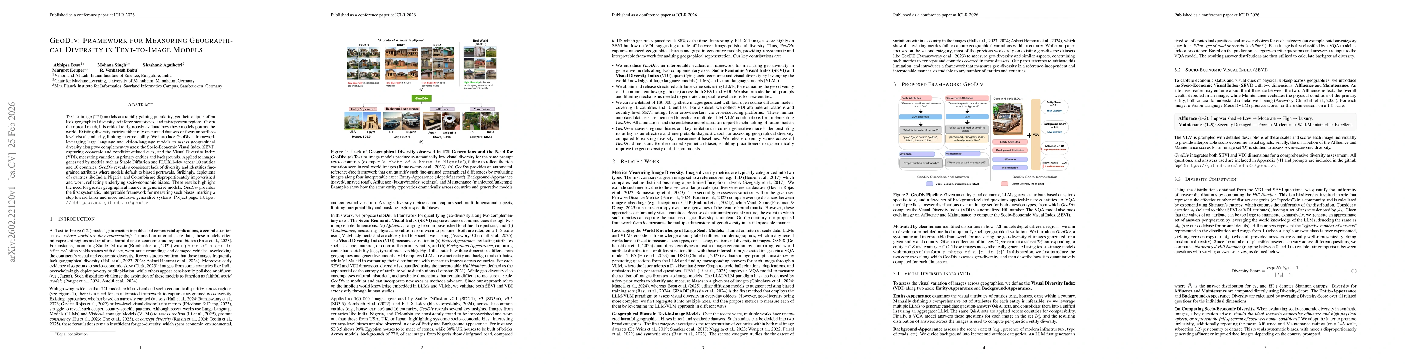
Text-to-image (T2I) models are rapidly gaining popularity, yet their outputs often lack geographical diversity, reinforce stereotypes, and misrepresent regions. Given their broad reach, it is critical to rigorously evaluate how these models portray the world. Existing diversity metrics either rely on curated datasets or focus on surface-level visual similarity, limiting interpretability. We introduce GeoDiv, a framework leveraging large language and vision-language models to assess geographical diversity along two complementary axes: the Socio-Economic Visual Index (SEVI), capturing economic and condition-related cues, and the Visual Diversity Index (VDI), measuring variation in primary entities and backgrounds. Applied to images generated by models such as Stable Diffusion and FLUX.1-dev across $10$ entities and $16$ countries, GeoDiv reveals a consistent lack of diversity and identifies fine-grained attributes where models default to biased portrayals. Strikingly, depictions of countries like India, Nigeria, and Colombia are disproportionately impoverished and worn, reflecting underlying socio-economic biases. These results highlight the need for greater geographical nuance in generative models. GeoDiv provides the first systematic, interpretable framework for measuring such biases, marking a step toward fairer and more inclusive generative systems. Project page: https://abhipsabasu.github.io/geodiv

AI Key Findings

Generated Feb 26, 2026

Methodology — What approach did the authors take?

The study builds a framework called GeoDiv that uses large language models and vision‑language models to compute two complementary diversity scores—Socio‑Economic Visual Index (SEVI) and Visual Diversity Index (VDI)—for images generated by text‑to‑image models across multiple entities and countries, and validates the scores with human annotators.

Key Results — What are the main findings?

  • GeoDiv reveals a consistent lack of geographical diversity in popular T2I models, with countries such as India, Nigeria, and Colombia disproportionately depicted as impoverished.
  • The framework identifies fine‑grained attribute biases, e.g., chairs lacking backrests in SD3.5 and FLUX.1, and background biases such as grass‑only backyards for the US and Nigeria.
  • A prompt‑based mitigation that explicitly specifies affluence levels increases diversity scores by an average of 0.33 across models, demonstrating actionable bias reduction.
  • The metric is statistically robust, converging with as few as 100 images per concept‑country pair and showing high agreement between closed‑source and open‑source VQA models.
  • Human validation shows strong inter‑annotator agreement (Kendall’s τ≈0.54 for SEVI and 87% agreement for VDI).

Significance — Why does this research matter?

GeoDiv provides the first systematic, interpretable framework for quantifying geographical bias in generative models, enabling developers and curators to detect, measure, and mitigate unfair representations, thereby advancing fairness and inclusivity in AI‑generated content.

Technical Contribution — What is the technical contribution?

GeoDiv introduces a multi‑axis diversity metric combining SEVI and VDI, computed via large language and vision‑language models, and provides a scalable pipeline for evaluating and improving geographic representation in text‑to‑image generation.

Novelty — What is new about this work?

Unlike prior metrics that rely on curated datasets or surface visual similarity, GeoDiv offers an interpretable, data‑driven, and model‑agnostic assessment of socio‑economic, entity, and background diversity across geographic regions, enabling actionable bias mitigation.

Limitations — What are the limitations of this study?

  • Reliance on VQA and LLM predictions may introduce model‑specific biases and limits generalizability beyond the evaluated datasets.
  • The study focuses on a limited set of entities (10) and countries (16), potentially overlooking diversity patterns in other contexts.

Future Work — What did the authors propose for future work?

  • Extend GeoDiv to a broader range of entities, cultures, and languages to capture more nuanced geographic diversity.
  • Integrate the framework into training pipelines to guide dataset curation and model fine‑tuning for bias mitigation.

Paper Details

Paper ID: 2602.22120
Comments: ICLR 2026
Categories:
cs.CV

How to Cite This Paper

BibTeX
@article{basu2026geodiv,
  title         = {GeoDiv: Framework For Measuring Geographical Diversity In Text-To-Image Models},
  author        = {Basu, Abhipsa and Keuper, Margret and Singh, Mohana and others},
  year          = {2026},
  eprint        = {2602.22120},
  archivePrefix = {arXiv},
  primaryClass  = {cs.CV},
}
APA 7
Basu, A., Keuper, M., Singh, M., Babu, R., & Agnihotri, S. (2026). GeoDiv: Framework For Measuring Geographical Diversity In Text-To-Image Models. arXiv. https://arxiv.org/abs/2602.22120
MLA 9
Basu, Abhipsa, et al. "GeoDiv: Framework For Measuring Geographical Diversity In Text-To-Image Models." arXiv, 2026, arxiv.org/abs/2602.22120.

Comments (0)

This website uses cookies to ensure you get the best experience. Learn more