ArxivLens

Publication

Published: Jun 02, 2025
Updated: Jun 17, 2025
Categories: cs.AI

Metrics

Source: ArXiv

AI Quick Summary

A new framework called GeoLocSFT improves visual geolocation accuracy by fine-tuning a large multimodal model with a small dataset, outperforming previous methods.

Quick Answers

What is "GeoLocSFT: Efficient Visual Geolocation via Supervised Fine-Tuning of Multimodal Foundation Models" about?

A new framework called GeoLocSFT improves visual geolocation accuracy by fine-tuning a large multimodal model with a small dataset, outperforming previous methods.

What methodology did the authors use?

The research introduces GeoLocSFT, a framework that employs targeted supervised fine-tuning (SFT) of a large multimodal foundation model (Gemma 3) using a small, high-quality dataset of 2700 image-GPS pairs from the MR600k dataset. More in Methodology →

What are the key results?

GeoLocSFT outperforms baseline models in visual geolocation tasks. — Robust results achieved on benchmarks like Im2GPS-3k, YFCC-4k, and the newly proposed MR40k benchmark, focusing on sparsely populated regions. More in Key Results →

Why is this work significant?

This research highlights the efficiency of high-quality supervision and SFT for planet-scale image geolocation, contrasting with prior methods requiring massive databases or complex pipelines. More in Significance →

What are the main limitations?

The method relies on a small, high-quality dataset (2700 image-GPS pairs) for fine-tuning. — Performance in highly similar-looking regions across the globe might still be challenging. More in Limitations →

Paper Preview

Abstract

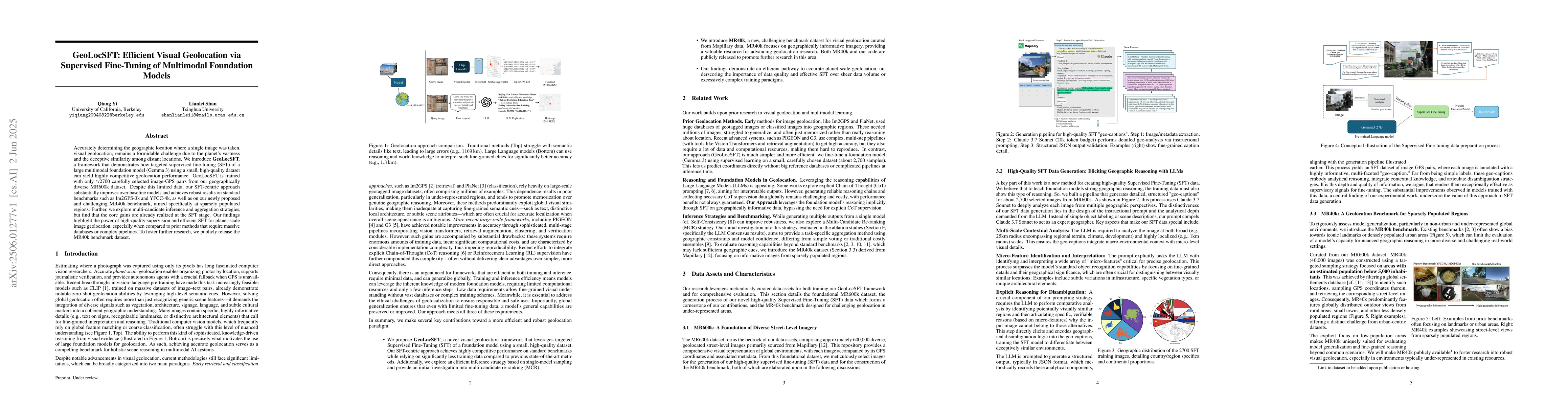
Accurately determining the geographic location where a single image was taken, visual geolocation, remains a formidable challenge due to the planet's vastness and the deceptive similarity among distant locations. We introduce GeoLocSFT, a framework that demonstrates how targeted supervised fine-tuning (SFT) of a large multimodal foundation model (Gemma 3) using a small, high-quality dataset can yield highly competitive geolocation performance. GeoLocSFT is trained with only 2700 carefully selected image-GPS pairs from our geographically diverse MR600k dataset. Despite this limited data, our SFT-centric approach substantially improves over baseline models and achieves robust results on standard benchmarks such as Im2GPS-3k and YFCC-4k, as well as on our newly proposed and challenging MR40k benchmark, aimed specifically at sparsely populated regions. Further, we explore multi-candidate inference and aggregation strategies but find that the core gains are already realized at the SFT stage. Our findings highlight the power of high-quality supervision and efficient SFT for planet-scale image geolocation, especially when compared to prior methods that require massive databases or complex pipelines. To foster further research, we publicly release the MR40k benchmark dataset.

Key Findings, in focus

Seven facets of this paper, analysed and brought into focus by AI.

AI-generated · verify against source Generated Jun 09, 2025
In focus · one-line synthesis

This research highlights the efficiency of high-quality supervision and SFT for planet-scale image geolocation, contrasting with prior methods requiring massive databases or complex pipelines.

01
MethodologyHow they did it

The research introduces GeoLocSFT, a framework that employs targeted supervised fine-tuning (SFT) of a large multimodal foundation model (Gemma 3) using a small, high-quality dataset of 2700 image-GPS pairs from the MR600k dataset.

02
ResultsWhat they found
  • GeoLocSFT outperforms baseline models in visual geolocation tasks.
  • Robust results achieved on benchmarks like Im2GPS-3k, YFCC-4k, and the newly proposed MR40k benchmark, focusing on sparsely populated regions.
  • Multi-candidate inference and aggregation strategies are explored, though core gains are realized at the SFT stage.
03
SignificanceWhy it matters

This research highlights the efficiency of high-quality supervision and SFT for planet-scale image geolocation, contrasting with prior methods requiring massive databases or complex pipelines.

04
Technical ContributionsWhat's new technically

GeoLocSFT, a framework utilizing supervised fine-tuning of multimodal foundation models for efficient visual geolocation with minimal data.

05
NoveltyWhat sets it apart

Unlike prior methods needing extensive databases or complex pipelines, GeoLocSFT demonstrates competitive geolocation performance using only 2700 carefully selected image-GPS pairs.

06
LimitationsWhat to be cautious about
  • The method relies on a small, high-quality dataset (2700 image-GPS pairs) for fine-tuning.
  • Performance in highly similar-looking regions across the globe might still be challenging.
07
Future WorkWhere it goes next
  • Investigate the application of GeoLocSFT on other geolocation-related tasks.
  • Explore the use of larger and more diverse datasets for further improving performance.

Impact

28
References

Paper Details

Paper ID: 2506.01277
Comments: 29 pages, 14 figures
Categories:
cs.AI

How to Cite This Paper

Reference manager: RIS EndNote

Citation Network

Current paper (gray), citations (green), references (blue)

Display is limited for performance on very large graphs.

Current Paper
Citations
References
Click to view


Discussion 0

This website uses cookies to ensure you get the best experience. Learn more