GeoNav: Empowering MLLMs with Explicit Geospatial Reasoning Abilities for Language-Goal Aerial Navigation

Source: ArXiv

AI Quick Summary

GeoNav, a multimodal agent, enables long-range language-goal aerial navigation in complex environments using spatial reasoning and structured memory, surpassing the state-of-the-art in success rate and navigation efficiency.

Share: Share on X LinkedIn

Summary

Language-goal aerial navigation is a critical challenge in embodied AI, requiring UAVs to localize targets in complex environments such as urban blocks based on textual specification. Existing methods, often adapted from indoor navigation, struggle to scale due to limited field of view, semantic ambiguity among objects, and lack of structured spatial reasoning. In this work, we 
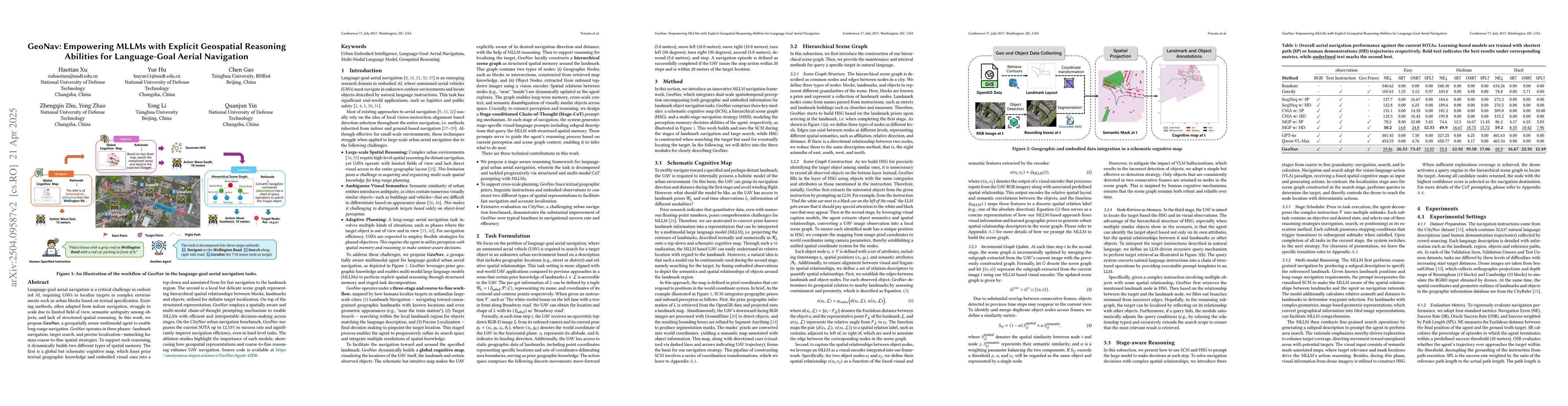
propose GeoNav, a geospatially aware multimodal agent to enable long-range navigation. GeoNav operates in three phases-landmark navigation, target search, and precise localization-mimicking human coarse-to-fine spatial strategies. To support such reasoning, it dynamically builds two different types of spatial memory. The first is a global but schematic cognitive map, which fuses prior textual geographic knowledge and embodied visual cues into a top-down, annotated form for fast navigation to the landmark region. The second is a local but delicate scene graph representing hierarchical spatial relationships between blocks, landmarks, and objects, which is used for definite target localization. On top of this structured representation, GeoNav employs a spatially aware, multimodal chain-of-thought prompting mechanism to enable multimodal large language models with efficient and interpretable decision-making across stages. On the CityNav urban navigation benchmark, GeoNav surpasses the current state-of-the-art by up to 12.53% in success rate and significantly improves navigation efficiency, even in hard-level tasks. Ablation studies highlight the importance of each module, showcasing how geospatial representations and coarse-to-fine reasoning enhance UAV navigation.

AI Key Findings

Generated Jun 09, 2025

Methodology

GeoNav, a geospatially aware multimodal agent, is proposed for language-goal aerial navigation, employing a three-stage approach: landmark navigation, target search, and precise localization. It constructs a global cognitive map and a local scene graph for efficient and interpretable decision-making.

Key Results

  • GeoNav outperforms current state-of-the-art methods by up to 12.53% in success rate on the CityNav benchmark.
  • GeoNav significantly improves navigation efficiency, especially in hard-level tasks.
  • Ablation studies highlight the importance of geospatial representations and coarse-to-fine reasoning for UAV navigation.
  • GeoNav demonstrates superior performance compared to rule-based, learning-based, and native MLLM methods in various difficulty levels.
  • GeoNav's three-stage strategy effectively reduces the search space and guides the UAV towards the target.

Significance

This research is significant as it addresses the critical challenge of language-goal aerial navigation in complex urban environments, improving upon existing methods that struggle with limited field of view, semantic ambiguity, and lack of structured spatial reasoning.

Technical Contribution

GeoNav introduces a geospatially aware multimodal agent that constructs a global cognitive map and a local scene graph, enabling efficient and interpretable decision-making for language-goal aerial navigation.

Novelty

GeoNav stands out by integrating explicit geospatial reasoning abilities into MLLMs, employing a coarse-to-fine spatial strategy, and dynamically building global and local spatial memories for long-range navigation in complex urban environments.

Limitations

  • The current multi-modal CoT prompting is token-intensive and requires a more elegant scheduling framework.
  • There is room for improvement in the joint construction and inference use of the two spatial representations to enhance model accuracy and semantics.

Future Work

  • Develop a more efficient scheduling framework for multi-modal CoT prompting.
  • Improve the joint construction and inference of the two spatial representations for better model accuracy and semantics.

Paper Details

PDF Preview

Download PDF

Citation Network

Current paper (gray), citations (green), references (blue)

Display is limited for performance on very large graphs.

Current Paper
Citations
References
Click to view
Title Authors Year Actions

Comments (0)

This website uses cookies to ensure you get the best experience. Learn more