Publication

Published: May 11, 2026
Categories: eess.IV, cs.AI, cs.CV

Metrics

Source: ArXiv

Quick Actions

View PDF

AI Quick Summary

The paper presents SMART-HC-VQA, a large Sentinel-2 dataset of construction-site activity questions and answers that tracks how site attributes evolve over time using multimodal language models. It introduces a workflow to create image chips and temporal VQA pairs, plus a multi-image MLLM training framework to reason about change, progress, and future activity in satellite imagery.

Quick Answers

What is "Geospatial-Temporal Sensemaking of Remote Sensing Activity Detections with Multimodal Large Language Model" about?

The paper presents SMART-HC-VQA, a large Sentinel-2 dataset of construction-site activity questions and answers that tracks how site attributes evolve over time using multimodal language models. It introduces a workflow to create image chips and temporal VQA pairs, plus a multi-image MLLM training framework to reason about change, progress, and future activity in satellite imagery.

What methodology did the authors use?

The study derives SMART-HC-VQA by converting SMART-HC annotations and Sentinel-2 imagery into natural-language VQA triplets, chips site-centered from large tiles, and applying a multi-image MLLM framework based on LLaVA-NeXT Mistral-7B to process multiple dated images and metadata-driven VQA examples. More in Methodology →

What are the key results?

SMART-HC-VQA comprises 21,837 Sentinel-2 image chips, 65,511 single-image VQA examples, and ~2.3 million two-image temporal-comparison examples generated via Image-Pairwise Combinatorial Augmentation. — A reproducible data preparation workflow is described for retrieval, alignment to SMART-HC annotations, and analysis of site size, observation count, temporal coverage, construction type, and phase labels. More in Key Results →

Why is this work significant?

The work provides a reproducible foundation for language-guided remote sensing sensemaking that goes beyond change detection to explain activity progression and future states, potentially aiding activity-based intelligence and geospatial-temporal reasoning. More in Significance →

What are the main limitations?

The paper emphasizes dataset derivation and framework rather than presenting final model evaluation results or deployed systems. — Temporal sparsity and sensing condition variability may limit generalization to other geographies or time spans. More in Limitations →

Paper Preview

Abstract

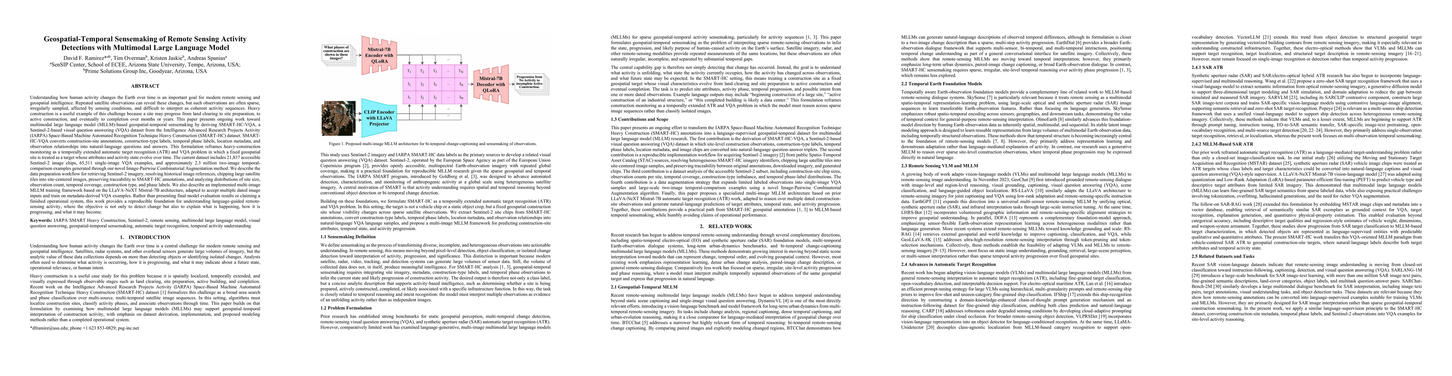
We introduce SMART-HC-VQA, a Sentinel-2-based visual question answering dataset derived from the IARPA SMART Heavy Construction dataset, designed for spatiotemporal analysis of human activity. The dataset transforms construction-site annotations, construction-type labels, temporal-phase labels, geographic metadata, and observation relationships into natural language question-answer triplets. This approach redefines the existing dataset as a temporally extended automatic target recognition and visual question answering (VQA) challenge, considering a fixed geospatial site as a target whose attributes and activity states evolve across sparse satellite observations. Currently, SMART-HC-VQA comprises 21,837 accessible Sentinel-2 image chips, 65,511 single-image VQA examples, and approximately 2.3 million two-image temporal comparison examples generated via our novel Image-Pairwise Combinatorial Augmentation. We detail the workflow for retrieving and processing Sentinel-2 imagery, segmenting large satellite tiles into site-centered images, maintaining traceability to SMART-HC annotations, and analyzing the distributions of site size, observation count, temporal coverage, construction type, and phase labels. Additionally, we describe an implemented multi-image MLLM training framework based on LLaVA-NeXT Mistral-7B, adapted to accept multiple dated image inputs and train on metadata-derived VQA examples. This work offers a reproducible foundation for understanding language-guided remote sensing activities, aiming not only to detect change but also to reason about the ongoing processes, their progression, and potential future developments.

AI Key Findings

Generated May 13, 2026

Methodology — What approach did the authors take?

The study derives SMART-HC-VQA by converting SMART-HC annotations and Sentinel-2 imagery into natural-language VQA triplets, chips site-centered from large tiles, and applying a multi-image MLLM framework based on LLaVA-NeXT Mistral-7B to process multiple dated images and metadata-driven VQA examples.

Key Results — What are the main findings?

  • SMART-HC-VQA comprises 21,837 Sentinel-2 image chips, 65,511 single-image VQA examples, and ~2.3 million two-image temporal-comparison examples generated via Image-Pairwise Combinatorial Augmentation.
  • A reproducible data preparation workflow is described for retrieval, alignment to SMART-HC annotations, and analysis of site size, observation count, temporal coverage, construction type, and phase labels.
  • An implemented multi-image MLLM training framework is presented, enabling prediction of construction-site attributes, temporal state, and activity progression using multiple dated image inputs.

Significance — Why does this research matter?

The work provides a reproducible foundation for language-guided remote sensing sensemaking that goes beyond change detection to explain activity progression and future states, potentially aiding activity-based intelligence and geospatial-temporal reasoning.

Technical Contribution — What is the technical contribution?

Introduction of SMART-HC-VQA as a Sentinel-2-based VQA dataset derived from SMART-HC annotations, a scalable data-prep and site-chip generation workflow, and a multi-image LLaVA-NeXT Mistral-7B-based training framework for temporal VQA with metadata integration.

Novelty — What is new about this work?

First to formalize geospatial-temporal sensemaking of construction activity using a large multimodal language model trained on multi-date satellite inputs and metadata-driven VQA, reframing ATR/VQA as temporally extended reasoning over evolving geospatial sites.

Limitations — What are the limitations of this study?

  • The paper emphasizes dataset derivation and framework rather than presenting final model evaluation results or deployed systems.
  • Temporal sparsity and sensing condition variability may limit generalization to other geographies or time spans.
  • No explicit real-world deployment or operational performance metrics are reported in this stage.

Future Work — What did the authors propose for future work?

  • Extend evaluation with end-to-end model performance on geospatial-temporal tasks and sensemaking benchmarks.
  • Explore additional multimodal modalities and more diverse temporal cadences to improve robustness.
  • Integrate with operational geospatial intelligence workflows and real-time update capabilities.

Paper Details

Paper ID: 2605.10739
Comments: Accepted to 2026 SPIE Defense + Security, Automatic Target Recognition XXXVI
Categories:
eess.IV cs.AI cs.CV

How to Cite This Paper

BibTeX
@article{spanias2026geospatial,
  title         = {Geospatial-Temporal Sensemaking of Remote Sensing Activity Detections with Multimodal Large Language Model},
  author        = {Spanias, Andreas and Ramirez, David F. and Jaskie, Kristen and others},
  year          = {2026},
  eprint        = {2605.10739},
  archivePrefix = {arXiv},
  primaryClass  = {eess.IV},
}
APA 7
Spanias, A., Ramirez, D., Jaskie, K., & Overman, T. (2026). Geospatial-Temporal Sensemaking of Remote Sensing Activity Detections with Multimodal Large Language Model. arXiv. https://arxiv.org/abs/2605.10739
MLA 9
Spanias, Andreas, et al. "Geospatial-Temporal Sensemaking of Remote Sensing Activity Detections with Multimodal Large Language Model." arXiv, 2026, arxiv.org/abs/2605.10739.

Comments (0)

This website uses cookies to ensure you get the best experience. Learn more