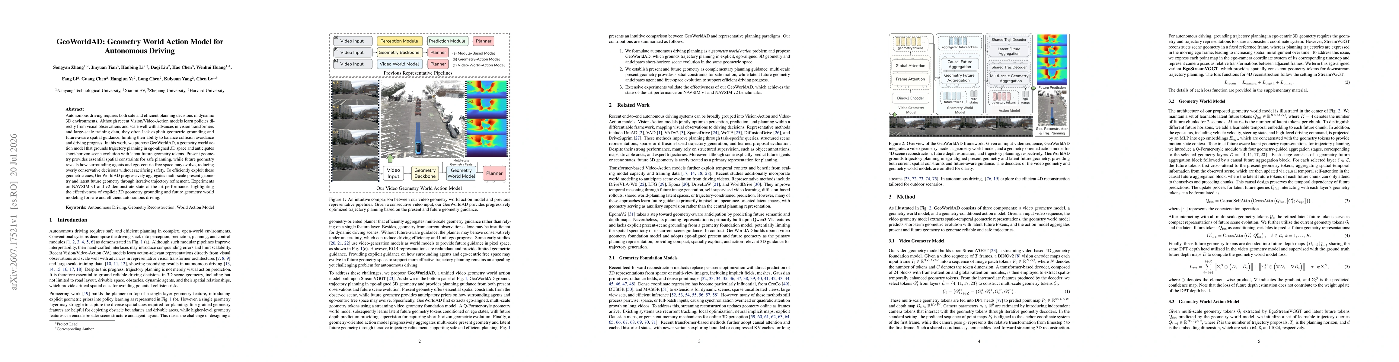
GeoWorldAD grounds trajectory planning in ego-aligned 3D space by progressively aggregating multi-scale present geometry and latent future geometry tokens. It uses an AQ-Former-style geometry world model to extract ego-aligned geometry tokens from streaming video, then predicts latent future geometry conditioned on past states with short-horizon depth supervision, and finally employs a geometry-oriented action model that refines trajectories iteratively to balance safety and efficiency.
GeoWorldAD: Geometry World Action Model for Autonomous Driving
Publication
Metrics
AI Quick Summary
GeoWorldAD introduces a geometry-grounded planning model for autonomous driving that anchors decisions in ego-centered 3D space and uses latent future geometry to anticipate short-term scene changes. By progressively integrating current and predicted geometric cues, the approach improves safety and efficiency, achieving state-of-the-art results on NAVSIM datasets without sacrificing forward progress.
Quick Answers
What is "GeoWorldAD: Geometry World Action Model for Autonomous Driving" about?
GeoWorldAD introduces a geometry-grounded planning model for autonomous driving that anchors decisions in ego-centered 3D space and uses latent future geometry to anticipate short-term scene changes. By progressively integrating current and predicted geometric cues, the approach improves safety and efficiency, achieving state-of-the-art results on NAVSIM datasets without sacrificing forward progress.
What methodology did the authors use?
GeoWorldAD grounds trajectory planning in ego-aligned 3D space by progressively aggregating multi-scale present geometry and latent future geometry tokens. It uses an AQ-Former-style geometry world model to extract ego-aligned geometry tokens from streaming video, then predicts latent future geometry conditioned on past states with short-horizon depth supervision, and finally employs a geometry-oriented action model that refines trajectories iteratively to balance... More in Methodology →
What are the key results?
Achieves state-of-the-art performance on NAVSIM v1 and v2, demonstrating the benefits of explicit 3D geometry grounding and future geometry modeling for safe and efficient autonomous driving. — The model effectively leverages present and future geometric cues to reduce conservatism without sacrificing safety, leading to improved trajectory quality in dynamic scenes. More in Key Results →
Why is this work significant?
Introduces explicit 3D geometric grounding and a latent future-geometry world model to guide trajectory planning, addressing limitations of purely visual action models by incorporating spatial constraints and forward-looking priors for safer and more efficient driving. More in Significance →
What are the main limitations?
Experimental validation appears limited to NAVSIM datasets; transferability to real-world diverse weather and lighting conditions is not detailed. — Reliance on accurate depth and geometry estimation may be sensitive to sensor noise and occlusions, which could impact planning under severe uncertainty. More in Limitations →
Abstract
Autonomous driving requires both safe and efficient planning decisions in dynamic 3D environments. Although recent Vision/Video-Action models learn policies directly from visual observations and scale well with advances in vision transformers and large-scale training data, they often lack explicit geometric grounding and future-aware spatial guidance, limiting their ability to balance collision avoidance and driving progress. In this work, we propose GeoWorldAD, a geometry world action model that grounds trajectory planning in ego-aligned 3D space and anticipates short-horizon scene evolution with latent future geometry tokens. Present geometry provides essential spatial constraints for safe planning, while future geometry reveals how surrounding agents and ego-centric free space may evolve, reducing overly conservative decisions without sacrificing safety. To efficiently exploit these geometric cues, GeoWorldAD progressively aggregates multi-scale present geometry and latent future geometry through iterative trajectory refinement. Experiments on NAVSIM v1 and v2 demonstrate state-of-the-art performance, highlighting the effectiveness of explicit 3D geometry grounding and future geometry world modeling for safe and efficient autonomous driving.
OpenAlex
- Citations in OpenAlex
- 0
- Publication year
- 2026
- Access status
- Open access
Source: OpenAlex · Snapshot
Key Findings, in focus
Seven facets of this paper, analysed and brought into focus by AI.
Introduces explicit 3D geometric grounding and a latent future-geometry world model to guide trajectory planning, addressing limitations of purely visual action models by incorporating spatial constraints and forward-looking priors for safer and more efficient driving.
- Achieves state-of-the-art performance on NAVSIM v1 and v2, demonstrating the benefits of explicit 3D geometry grounding and future geometry modeling for safe and efficient autonomous driving.
- The model effectively leverages present and future geometric cues to reduce conservatism without sacrificing safety, leading to improved trajectory quality in dynamic scenes.
Introduces explicit 3D geometric grounding and a latent future-geometry world model to guide trajectory planning, addressing limitations of purely visual action models by incorporating spatial constraints and forward-looking priors for safer and more efficient driving.
Proposes GeoWorldAD, a unified video geometry world action model that grounds planning in ego-aligned 3D space using multi-scale present geometry tokens and latent future geometry tokens, with a streaming geometry foundation and iterative trajectory refinement for safe and efficient autonomous driving.
Combines an AQ-Former-style geometry world model for token-based 3D geometry extraction with latent future geometry conditioned on short-horizon scene evolution, integrated into a geometry-oriented trajectory planner that progressively fuses present and future geometric cues.
- Experimental validation appears limited to NAVSIM datasets; transferability to real-world diverse weather and lighting conditions is not detailed.
- Reliance on accurate depth and geometry estimation may be sensitive to sensor noise and occlusions, which could impact planning under severe uncertainty.
- Extend evaluation to real-world driving datasets to assess robustness and generalization across environments.
- Investigate integration with other sensing modalities (e.g., LiDAR, radar) to strengthen geometric grounding under challenging conditions.
- Explore scalable improvements in computation to enable real-time deployment on resource-constrained platforms.
Discussion 0