Graph-based LiDAR pose tracking that uses compact structural map priors represented as lightweight point-line graphs; it retrieves a pose-conditioned visible subgraph via LiDAR ray casting, matches scan-to-map with unbalanced optimal transport incorporating graph-context regularization, applies dynamic filtering of features, and employs degeneracy-aware delayed optimization for low-observability segments
Graph-Loc: Robust Graph-Based LiDAR Pose Tracking with Compact Structural Map Priors under Low Observability and Occlusion
Publication
Metrics
Quick Answers
What methodology did the authors use?
Graph-based LiDAR pose tracking that uses compact structural map priors represented as lightweight point-line graphs; it retrieves a pose-conditioned visible subgraph via LiDAR ray casting, matches scan-to-map with unbalanced optimal transport incorporating graph-context regularization, applies dynamic filtering of features, and employs degeneracy-aware delayed optimization for low-observability segments More in Methodology →
What are the key results?
Achieves competitive accuracy on KITTI and ERPoT datasets while reducing prior size by 10–15% compared to split-based polygon pipelines — Demonstrates robust tracking under occlusion and low observability in controlled indoor simulations and real-world deployments, outperforming point-cloud and baseline polygon priors More in Key Results →
Why is this work significant?
Enables scalable, real-time LiDAR localization with minimal map storage, improving long-term autonomous operation in environments with partial visibility and dynamic occlusions More in Significance →
What are the main limitations?
Relies on Manhattan-world assumptions for structural inference, limiting applicability in highly irregular scenes — Performance can degrade when prior maps are significantly mismatched due to large scene changes, though still better than baselines More in Limitations →
Abstract
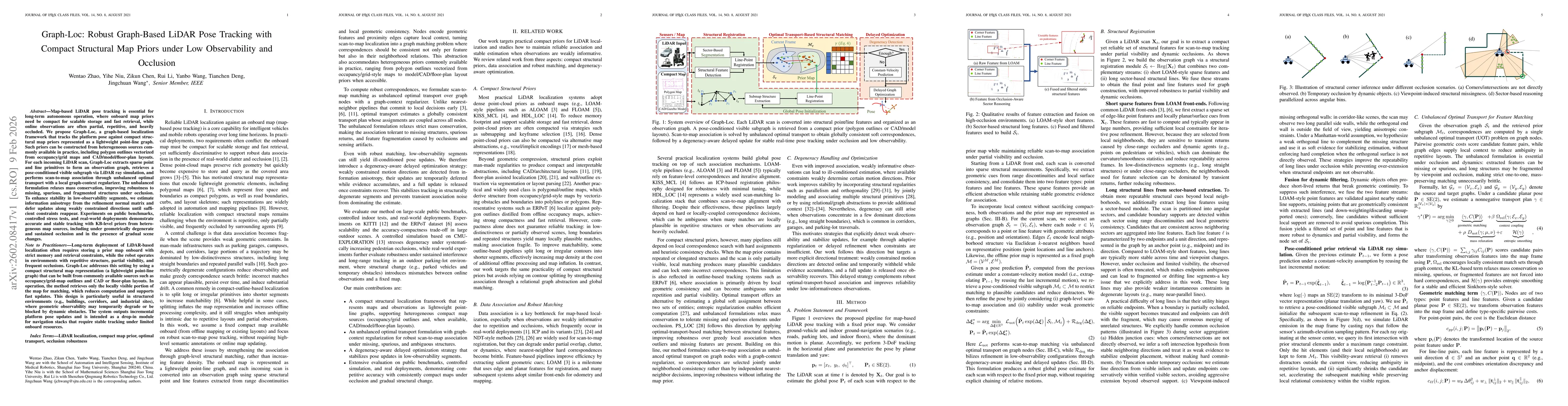
Map-based LiDAR pose tracking is essential for long-term autonomous operation, where onboard map priors need be compact for scalable storage and fast retrieval, while online observations are often partial, repetitive, and heavily occluded. We propose Graph-Loc, a graph-based localization framework that tracks the platform pose against compact structural map priors represented as a lightweight point-line graph. Such priors can be constructed from heterogeneous sources commonly available in practice, including polygon outlines vectorized from occupancy/grid maps and CAD/model/floor-plan layouts. For each incoming LiDAR scan, Graph-Loc extracts sparse point and line primitives to form an observation graph, retrieves a pose-conditioned visible subgraph via LiDAR ray simulation, and performs scan-to-map association through unbalanced optimal transport with a local graph-context regularizer. The unbalanced formulation relaxes mass conservation, improving robustness to missing, spurious, and fragmented structures under occlusion. To enhance stability in low-observability segments, we estimate information anisotropy from the refinement normal matrix and defer updates along weakly constrained directions until sufficient constraints reappear. Experiments on public benchmarks, controlled stress tests, and real-world deployments demonstrate accurate and stable tracking with KB-level priors from heterogeneous map sources, including under geometrically degenerate and sustained occlusion and in the presence of gradual scene changes.
Key Findings, in focus
Seven facets of this paper, analysed and brought into focus by AI.
Enables scalable, real-time LiDAR localization with minimal map storage, improving long-term autonomous operation in environments with partial visibility and dynamic occlusions
- Achieves competitive accuracy on KITTI and ERPoT datasets while reducing prior size by 10–15% compared to split-based polygon pipelines
- Demonstrates robust tracking under occlusion and low observability in controlled indoor simulations and real-world deployments, outperforming point-cloud and baseline polygon priors
- Provides lower runtime latency, especially with GPU acceleration, outperforming ERPoT in per-scan processing time
Enables scalable, real-time LiDAR localization with minimal map storage, improving long-term autonomous operation in environments with partial visibility and dynamic occlusions
Global scan-to-map association via unbalanced optimal transport on point-line graphs with graph-context regularization, combined with degeneracy-aware delayed optimization to stabilize pose updates in low-observability segments
Combines split-free polygon outline priors with global unbalanced OT matching and degeneracy-aware optimization, eliminating the need for contour splitting and enabling robust localization with minimal map size
- Relies on Manhattan-world assumptions for structural inference, limiting applicability in highly irregular scenes
- Performance can degrade when prior maps are significantly mismatched due to large scene changes, though still better than baselines
- Extend the framework to 3D structural priors beyond planar assumptions for more general environments
- Integrate loop closure and long-term map updating mechanisms to handle gradual scene changes
Discussion 0