A new method for gravity field mapping using laser-coupled quantum accelerometers in space offers improved performance with resolutions as low as 222km.
The emergence of quantum technologies, including cold atom based accelerometers, offers an opportunity to improve the performances of space geodesy missions. In this context, CNES initiated an assessment study called GRICE (GRadiom\'etrie \`a Interf\'erom\`etres quantiques Corr\'el\'es pour l'Espace) in order to evaluate the contribution of cold atom technologies to space geodesy and to the end users of geodetic data. In this paper, we present 
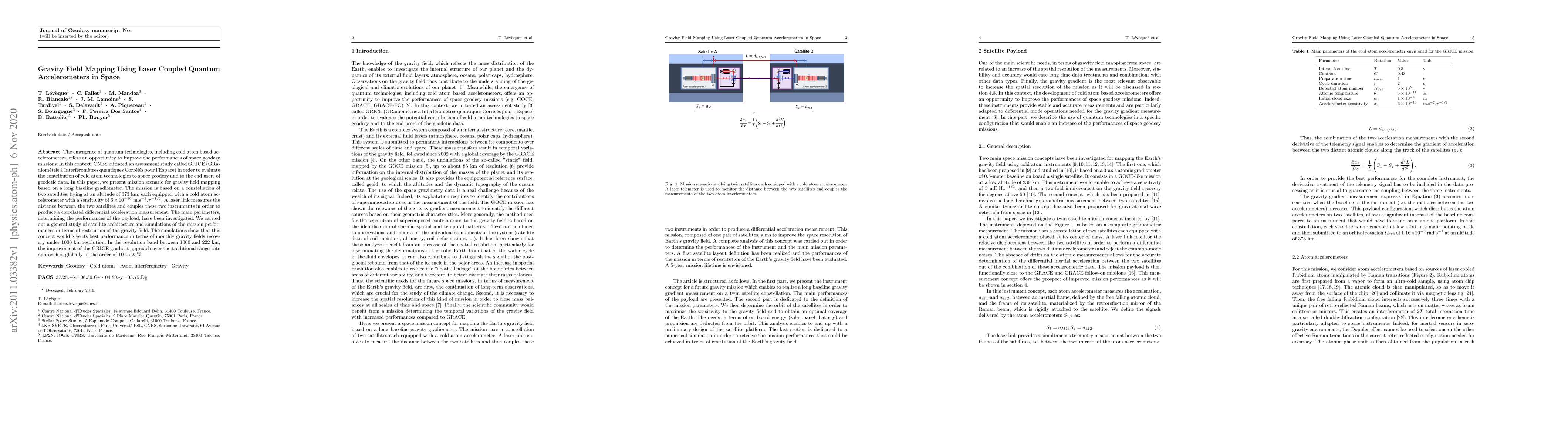
mission scenario for gravity field mapping based on a long baseline gradiometer. The mission is based on a constellation of two satellites, flying at an altitude of 373 km, each equipped with a cold atom accelerometer with a sensitivity of $6 \times 10^{-10}$~m.s$^{-2}$.$\mathrm{\tau}^{-1/2}$. A laser link measures the distance between the two satellites and couples these two instruments in order to produce a correlated differential acceleration measurement. The main parameters, determining the performances of the payload, have been investigated. We carried out a general study of satellite architecture and simulations of the mission performances in terms of restitution of the gravity field. The simulations show that this concept would give its best performance in terms of monthly gravity fields recovery under 1000~km resolution. In the resolution band between 1000 and 222~km, the improvement of the GRICE gradient approach over the traditional range-rate approach is globally in the order of 10 to 25\%.
Generated Sep 03, 2025
Numerical simulations were conducted to evaluate the GRICE concept's performance in recovering gravity fields, considering realistic environmental conditions projected 10-15 years into the future. The simulations incorporated model and instrumental noise, using a gradient approach with acceleration measurements from cold atom accelerometers and inter-satellite acceleration measurements derived from laser link range measurements.
This research assesses the potential of using quantum technologies, specifically cold atom accelerometers, for space geodesy missions, aiming to enhance gravity field mapping resolution. Improved gravity field mapping could benefit various Earth science applications, including hydrology, glaciology, oceanography, and internal geophysics, leading to a better understanding of Earth's climate change and internal structure.
The development and assessment of a space mission concept utilizing laser-couple quantum accelerometers for high-resolution gravity field mapping, along with a gradient approach for data processing.
This research proposes a novel space mission concept that leverages quantum technologies, specifically cold atom accelerometers, to enhance gravity field mapping resolution and improve Earth science applications.
Current paper (gray), citations (green), references (blue)
Display is limited for performance on very large graphs.
Jürgen Müller, Alireza HosseiniArani, Manuel Schilling et al.
Title | Authors | Year | Actions |
---|
Comments (0)