Summary

Recently spatial-temporal intelligence of Visual-Language Models (VLMs) has attracted much attention due to its importance for Autonomous Driving, Embodied AI and General Artificial Intelligence. Existing spatial-temporal benchmarks mainly focus on egocentric perspective reasoning with images/video context, or geographic perspective reasoning with graphics context (eg. a map), thus fail to assess VLMs' geographic spatial-temporal intelligence with both images/video and graphics context, which is important for areas like traffic management and 
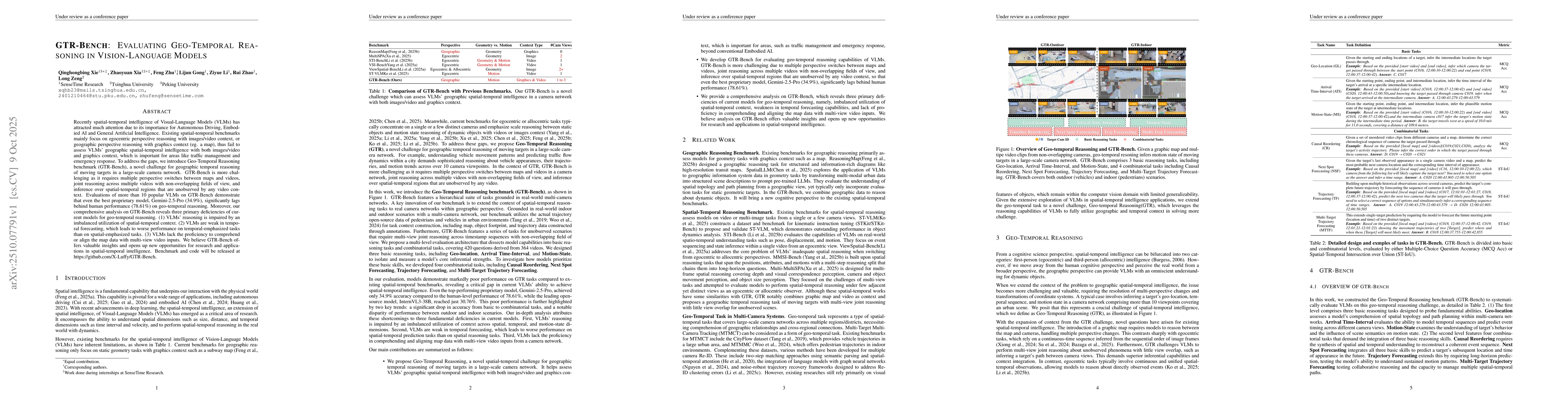
emergency response. To address the gaps, we introduce Geo-Temporal Reasoning benchmark (GTR-Bench), a novel challenge for geographic temporal reasoning of moving targets in a large-scale camera network. GTR-Bench is more challenging as it requires multiple perspective switches between maps and videos, joint reasoning across multiple videos with non-overlapping fields of view, and inference over spatial-temporal regions that are unobserved by any video context. Evaluations of more than 10 popular VLMs on GTR-Bench demonstrate that even the best proprietary model, Gemini-2.5-Pro (34.9%), significantly lags behind human performance (78.61%) on geo-temporal reasoning. Moreover, our comprehensive analysis on GTR-Bench reveals three primary deficiencies of current models for geo-temporal reasoning. (1) VLMs' reasoning is impaired by an imbalanced utilization of spatial-temporal context. (2) VLMs are weak in temporal forecasting, which leads to worse performance on temporal-emphasized tasks than on spatial-emphasized tasks. (3) VLMs lack the proficiency to comprehend or align the map data with multi-view video inputs. We believe GTR-Bench offers valuable insights and opens up new opportunities for research and applications in spatial-temporal intelligence. Benchmark and code will be released at https://github.com/X-Luffy/GTR-Bench.

AI Key Findings

Generated Oct 11, 2025

Methodology

The research introduces Geo-Reasoning Benchmarks (GRB) that integrate spatial-temporal reasoning tasks with real-world multi-camera surveillance data, utilizing detailed map annotations and video sequences to evaluate models' ability to understand complex environmental interactions.

Key Results

  • State-of-the-art models exhibit significant failures in topology understanding (28.6%) and FoV alignment (16.8%) across multi-viewpoint scenarios
  • Temporal reasoning errors show 12.4% error rate due to incorrect time interval estimations
  • Motion state prediction accuracy drops by 20.4% when transforming video coordinates to world coordinates

Significance

This work establishes a comprehensive benchmark for spatial-temporal reasoning in surveillance systems, highlighting critical gaps in current AI models' ability to handle complex real-world navigation and interaction scenarios.

Technical Contribution

The paper proposes a novel benchmark framework that systematically evaluates spatial-temporal reasoning capabilities through geo-located video sequences, map annotations, and multi-camera coordination analysis.

Novelty

This work introduces the first comprehensive benchmark specifically designed for geo-temporal reasoning tasks in multi-camera surveillance systems, addressing unique challenges in cross-viewpoint spatial understanding and temporal sequence prediction.

Limitations

  • Benchmark focuses primarily on indoor navigation scenarios with limited outdoor coverage
  • Assumes perfect map annotations which may not reflect real-world GPS inaccuracies

Future Work

  • Develop hybrid models combining visual and semantic reasoning for multi-modal understanding
  • Create dynamic benchmarks with real-time GPS data integration
  • Explore federated learning approaches for privacy-preserving surveillance analysis

Paper Details

PDF Preview

Download PDF

Comments (0)

This website uses cookies to ensure you get the best experience. Learn more