Publication
Metrics
AI Quick Summary
HeightLane presents a novel method for 3D lane detection using a heightmap derived from monocular images, addressing depth ambiguity and complex ground modeling through a multi-slope assumption and deformable attention-based feature transformation. It achieves state-of-the-art performance on the OpenLane dataset.
Paper Preview
Abstract
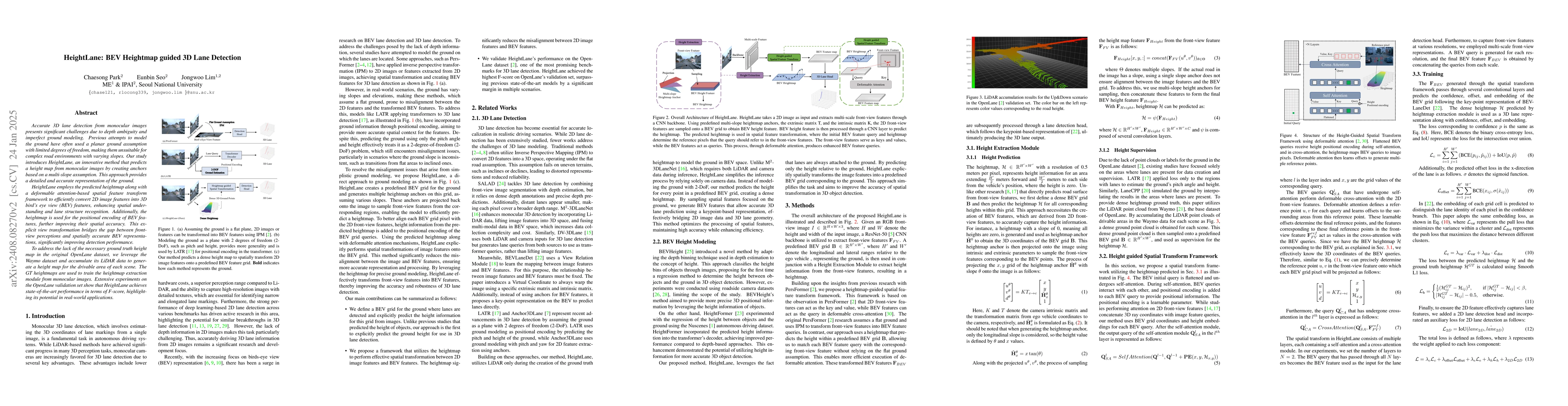
Accurate 3D lane detection from monocular images presents significant challenges due to depth ambiguity and imperfect ground modeling. Previous attempts to model the ground have often used a planar ground assumption with limited degrees of freedom, making them unsuitable for complex road environments with varying slopes. Our study introduces HeightLane, an innovative method that predicts a height map from monocular images by creating anchors based on a multi-slope assumption. This approach provides a detailed and accurate representation of the ground. HeightLane employs the predicted heightmap along with a deformable attention-based spatial feature transform framework to efficiently convert 2D image features into 3D bird's eye view (BEV) features, enhancing spatial understanding and lane structure recognition. Additionally, the heightmap is used for the positional encoding of BEV features, further improving their spatial accuracy. This explicit view transformation bridges the gap between front-view perceptions and spatially accurate BEV representations, significantly improving detection performance. To address the lack of the necessary ground truth (GT) height map in the original OpenLane dataset, we leverage the Waymo dataset and accumulate its LiDAR data to generate a height map for the drivable area of each scene. The GT heightmaps are used to train the heightmap extraction module from monocular images. Extensive experiments on the OpenLane validation set show that HeightLane achieves state-of-the-art performance in terms of F-score, highlighting its potential in real-world applications.
AI Key Findings
Get AI-generated insights about this paper's methodology, results, significance, and more — seven facets brought into focus.
Impact
Paper Details
Authors
PDF Preview
Key Terms
Citation Network
Current paper (gray), citations (green), references (blue)
Display is limited for performance on very large graphs.
Discussion 0