ArxivLens

Quick Summary:

This research introduces an "Implicit Ray-Transformer (IRT)" based on Implicit Neural Representation (INR) for remote sensing image semantic segmentation with limited labeled data. The proposed method leverages multi-view 3D structure priors and a two-stage learning process to achieve accurate and consistent segmentation, outperforming existing CNN-based and INR-based methods. For more details, refer to the original paper.

DOI: 10.1109/TGRS.2023.3285659
arXiv Id: 2303.08401
Date Published: 2023-08-09
Date Updated: 2023-08-09

Categories:

Key Terms (TF-IDF):

scene (0.223)
segmentation (0.223)
multi view (0.217)
rs (0.217)
semantic segmentation (0.216)
scene (0.211)
semantic segmentation (0.208)
segmentation (0.207)
cnn (0.196)
semantic (0.189)
semantic (0.181)
cnn (0.178)
view (0.175)
remote (0.174)
remote sensing (0.173)
stage (0.169)
view (0.167)
texture (0.166)
stage (0.163)
proposed method (0.158)
License: http://creativecommons.org/publicdomain/zero/1.0/

Summary:

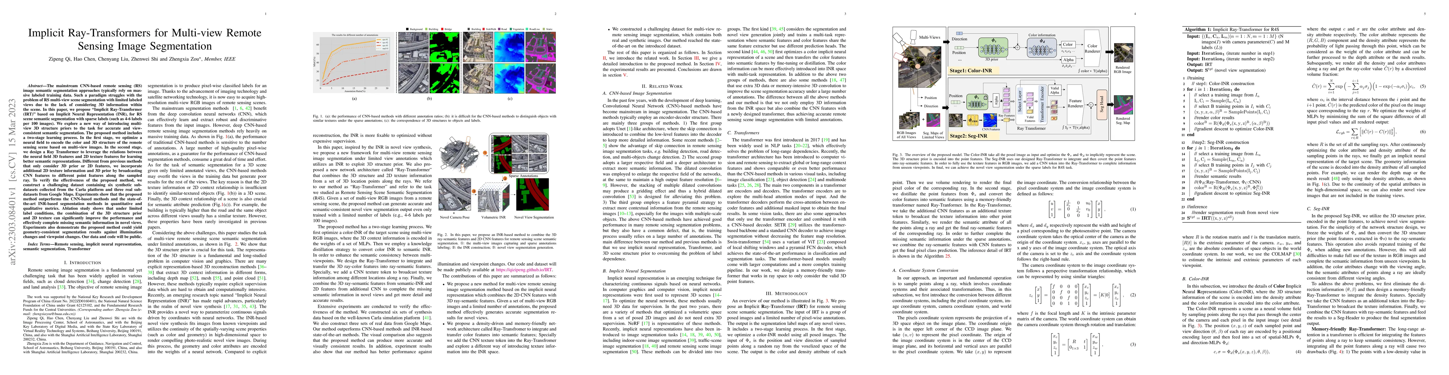
The mainstream CNN-based remote sensing (RS) image semantic segmentation approaches typically rely on massive labeled training data. Such a paradigm struggles with the problem of RS multi-view scene segmentation with limited labeled views due to the lack of considering 3D information within the scene. In this paper, we propose ''Implicit Ray-Transformer (IRT)'' based on Implicit Neural Representation (INR), for RS scene semantic segmentation with sparse labels (such as 4-6 labels per 100 images). We explore a new way of introducing multi-view 3D structure priors to the task for accurate and view-consistent semantic segmentation. The proposed method includes a two-stage learning process. In the first stage, we optimize a neural field to encode the color and 3D structure of the remote sensing scene based on multi-view images. In the second stage, we design a Ray Transformer to leverage the relations between the neural field 3D features and 2D texture features for learning better semantic representations. Different from previous methods that only consider 3D prior or 2D features, we incorporate additional 2D texture information and 3D prior by broadcasting CNN features to different point features along the sampled ray. To verify the effectiveness of the proposed method, we construct a challenging dataset containing six synthetic sub-datasets collected from the Carla platform and three real sub-datasets from Google Maps. Experiments show that the proposed method outperforms the CNN-based methods and the state-of-the-art INR-based segmentation methods in quantitative and qualitative metrics.

Citation & Reference Network Visualization

This graph shows how this paper is connected to other research. The current paper is shown in dark gray, papers that cite it are in green, and papers it references are in blue. You can:

Current Paper
Papers citing this work (Citations)
Papers cited by this work (References)

• Hover over any node to see the paper title

• Click a node to view that paper's details

• Drag nodes to rearrange the graph

• Use the zoom controls (bottom right) to zoom in/out

Citations and References

Title Authors Year Actions
TriDF: Triplane-Accelerated Density Fields for Few-Shot Remote Sensing Novel View Synthesis
Jiaming Kang, Keyan Chen, Zhengxia Zou, Z. Shi
2025
View Paper
From stone to story: mapping the thematic evolution of the great wall's global heritage
Yukuo Wang, Jiangfei Chen, Xin Feng, Juan Du
2025
View Paper
Efficient Semantic Splatting for Remote Sensing Multi-view Segmentation
Zipeng Qi, Hao Chen, Haotian Zhang, Zhengxia Zou, Z. Shi
2024
View Paper
Building extraction from remote sensing images with deep learning: A survey on vision techniques
Yuan Yuan, Xiaofeng Shi, Jun-Ge Gao
2024
View Paper
Joint-Optimized Unsupervised Adversarial Domain Adaptation in Remote Sensing Segmentation with Prompted Foundation Model
Shuchang Lyu, Qi Zhao, Guangliang Cheng, Yiwei He, Zheng Zhou, Guangbiao Wang, Zhenwei Shi
2024
View Paper
End-to-end multiview fusion for building mapping from aerial images
Qi Chen, Wenxiang Gan, Pengjie Tao, Penglei Zhang, Rongyong Huang, Lei Wang
2024
View Paper
Multi-View Remote Sensing Image Segmentation with Sam Priors
Zipeng Qi, Chenyang Liu, Zili Liu, Hao Chen, Yongchang Wu, Zhengxia Zou, Zhenwei Sh
2024
View Paper
Change-Agent: Toward Interactive Comprehensive Remote Sensing Change Interpretation and Analysis
Chenyang Liu, Keyan Chen, Haotian Zhang, Zipeng Qi, Zhengxia Zou, Z. Shi
2024
View Paper
Continuous Cross-Resolution Remote Sensing Image Change Detection
Hao Chen, Haotian Zhang, Keyan Chen, Chenyao Zhou, Songhang Chen, Zhengxia Zou, Z. Shi
2023
View Paper
Generating Imperceptible and Cross-Resolution Remote Sensing Adversarial Examples Based on Implicit Neural Representations
Yu Zhang, Jianqi Chen, Liqin Liu, Keyan Chen, Z. Shi, Zhengxia Zou
2024
View Paper
Progressive Refinement Network for Remote Sensing Image Change Detection
Xinghan Xu, Yi Liang, Jianwei Liu, Chengkun Zhang, Deyi Wang
2024
View Paper
A Decoupling Paradigm With Prompt Learning for Remote Sensing Image Change Captioning
Chenyang Liu, Rui Zhao, Jianqi Chen, Zipeng Qi, Zhengxia Zou, Z. Shi
2023
View Paper
Remote Sensing Image Change Detection Towards Continuous Bitemporal Resolution Differences
Hao Chen, Haotian Zhang, Keyan Chen, Chenyao Zhou, Songhang Chen, Zhengxia Zhou, Z. Shi
2023
View Paper

Similar Papers

Multi-view Remote Sensing Image Segmentation With SAM priors

Hao Chen, Zhengxia Zou, Chenyang Liu, Zipeng Qi, Zili Liu, Yongchang Wu, Zhenwei Sh

Published: 2024-05-24

Remote Sensing Novel View Synthesis with Implicit Multiplane Representations

Zhenwei Shi, Zhengxia Zou, Yongchang Wu

Published: 2022-10-05

RRSIS: Referring Remote Sensing Image Segmentation

Xiao Xiang Zhu, Zhenghang Yuan, Lichao Mou, Yuansheng Hua

Published: 2024-03-05

Comments (0)

This website uses cookies to ensure you get the best experience. Learn more