The research employs a graph-based deep learning framework, GraphTopoNet, which constructs spatial graphs from surface-derived covariates and incorporates gradient and polynomial trend surface augmentations. It uses a hybrid loss function combining radar confidence-weighted supervision, full-coverage reference guidance, and Monte Carlo Dropout for uncertainty regularization.
Improving Greenland Bed Topography Mapping with Uncertainty-Aware Graph Learning on Sparse Radar Data
Publication
Metrics
Quick Answers
What methodology did the authors use?
The research employs a graph-based deep learning framework, GraphTopoNet, which constructs spatial graphs from surface-derived covariates and incorporates gradient and polynomial trend surface augmentations. It uses a hybrid loss function combining radar confidence-weighted supervision, full-coverage reference guidance, and Monte Carlo Dropout for uncertainty regularization. More in Methodology →
What are the key results?
GraphTopoNet outperforms interpolation, convolutional, and graph-based baselines in both random and spatially disjoint evaluation settings — The model achieves high accuracy with MAE of 9.59m and R2 of 0.992 in spatial extrapolation tasks More in Key Results →
Why is this work significant?
This work advances spatial prediction under sparse supervision, enabling more accurate subglacial topography mapping which is critical for understanding climate change impacts and improving ice sheet models. More in Significance →
What are the main limitations?
Dependence on BedMachine as fallback supervision source with potential biases — Limited evaluation to three Greenland sub-regions More in Limitations →
Abstract
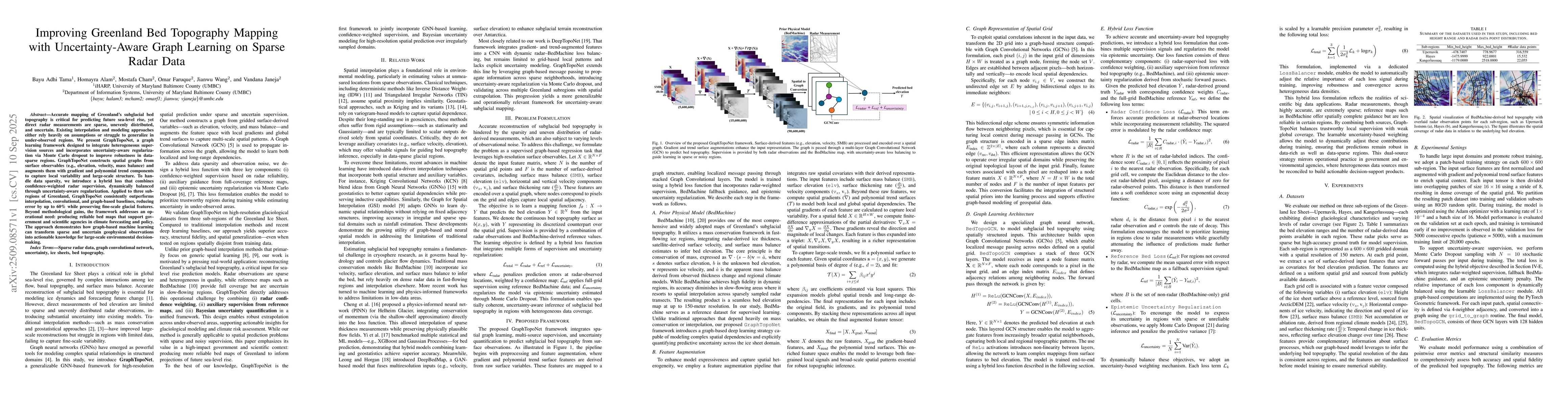
Accurate maps of Greenland's subglacial bed are essential for sea-level projections, but radar observations are sparse and uneven. We introduce GraphTopoNet, a graph-learning framework that fuses heterogeneous supervision and explicitly models uncertainty via Monte Carlo dropout. Spatial graphs built from surface observables (elevation, velocity, mass balance) are augmented with gradient features and polynomial trends to capture both local variability and broad structure. To handle data gaps, we employ a hybrid loss that combines confidence-weighted radar supervision with dynamically balanced regularization. Applied to three Greenland subregions, GraphTopoNet outperforms interpolation, convolutional, and graph-based baselines, reducing error by up to 60 percent while preserving fine-scale glacial features. The resulting bed maps improve reliability for operational modeling, supporting agencies engaged in climate forecasting and policy. More broadly, GraphTopoNet shows how graph machine learning can convert sparse, uncertain geophysical observations into actionable knowledge at continental scale.
Key Findings, in focus
Seven facets of this paper, analysed and brought into focus by AI.
This work advances spatial prediction under sparse supervision, enabling more accurate subglacial topography mapping which is critical for understanding climate change impacts and improving ice sheet models.
- GraphTopoNet outperforms interpolation, convolutional, and graph-based baselines in both random and spatially disjoint evaluation settings
- The model achieves high accuracy with MAE of 9.59m and R2 of 0.992 in spatial extrapolation tasks
- Integration of spatial priors and dual-source supervision enhances prediction coherence
This work advances spatial prediction under sparse supervision, enabling more accurate subglacial topography mapping which is critical for understanding climate change impacts and improving ice sheet models.
Development of a hybrid loss function with Monte Carlo Dropout for epistemic uncertainty regularization and integration of spatial priors with dual-source supervision
Combines graph neural networks with spatial surface covariates and dual supervision sources, enabling robust predictions in sparse observational scenarios
- Dependence on BedMachine as fallback supervision source with potential biases
- Limited evaluation to three Greenland sub-regions
- Extend framework to entire Greenland Ice Sheet and Antarctic regions
- Incorporate physics-informed constraints and temporal surface features
Discussion 0