Improving Toponym Resolution with Better Candidate Generation, Transformer-based Reranking, and Two-Stage Resolution
Publication
Metrics
AI Quick Summary
The paper proposes GeoNorm, a two-stage framework for improving toponym resolution through candidate generation and transformer-based reranking, achieving state-of-the-art performance on multiple datasets. Code and models are available for public use.
Paper Preview
Abstract
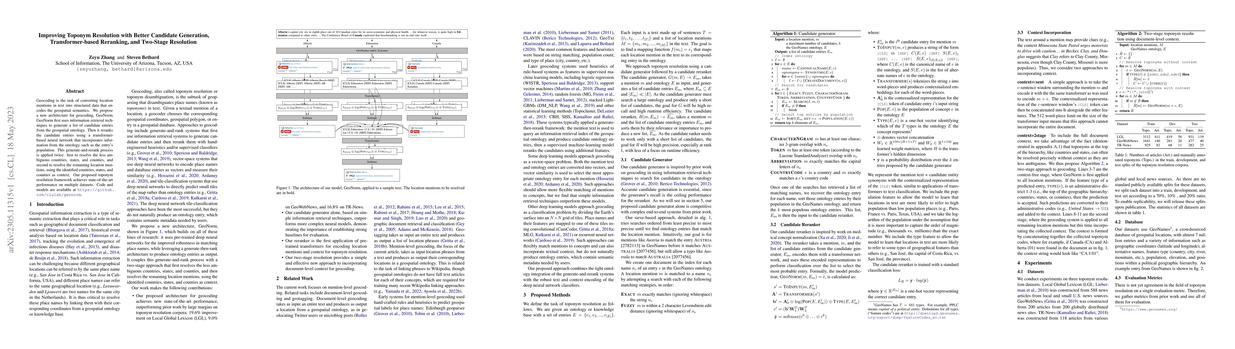
Geocoding is the task of converting location mentions in text into structured data that encodes the geospatial semantics. We propose a new architecture for geocoding, GeoNorm. GeoNorm first uses information retrieval techniques to generate a list of candidate entries from the geospatial ontology. Then it reranks the candidate entries using a transformer-based neural network that incorporates information from the ontology such as the entry's population. This generate-and-rerank process is applied twice: first to resolve the less ambiguous countries, states, and counties, and second to resolve the remaining location mentions, using the identified countries, states, and counties as context. Our proposed toponym resolution framework achieves state-of-the-art performance on multiple datasets. Code and models are available at \url{https://github.com/clulab/geonorm}.
AI Key Findings
Get AI-generated insights about this paper's methodology, results, significance, and more — seven facets brought into focus.
Impact
Paper Details
Authors
PDF Preview
Key Terms
Citation Network
Current paper (gray), citations (green), references (blue)
Display is limited for performance on very large graphs.
Discussion 0