Quick Answers
What methodology did the authors use?
Incrementally builds factor graphs by clustering adjacent core measurements, generating all valid cluster combinations, and selecting the best graph topology using a mutually orthogonal metric (MOM) to evaluate map quality. More in Methodology →
What are the key results?
Achieves ~30% reduction in factor graph size while preserving map quality. — Maintains trajectory RMSE comparable to baseline across diverse urban scenarios. More in Key Results →
Why is this work significant?
Provides a scalable SLAM framework that efficiently fuses heterogeneous, asynchronous sensors, reducing memory and computation while ensuring accurate localization and mapping in real-world urban environments. More in Significance →
What are the main limitations?
Performance degrades under high-speed dynamics where merging errors increase. — Relies on GPS and LiDAR with orthogonal features; fails in feature-sparse environments like tunnels. More in Limitations →
Abstract
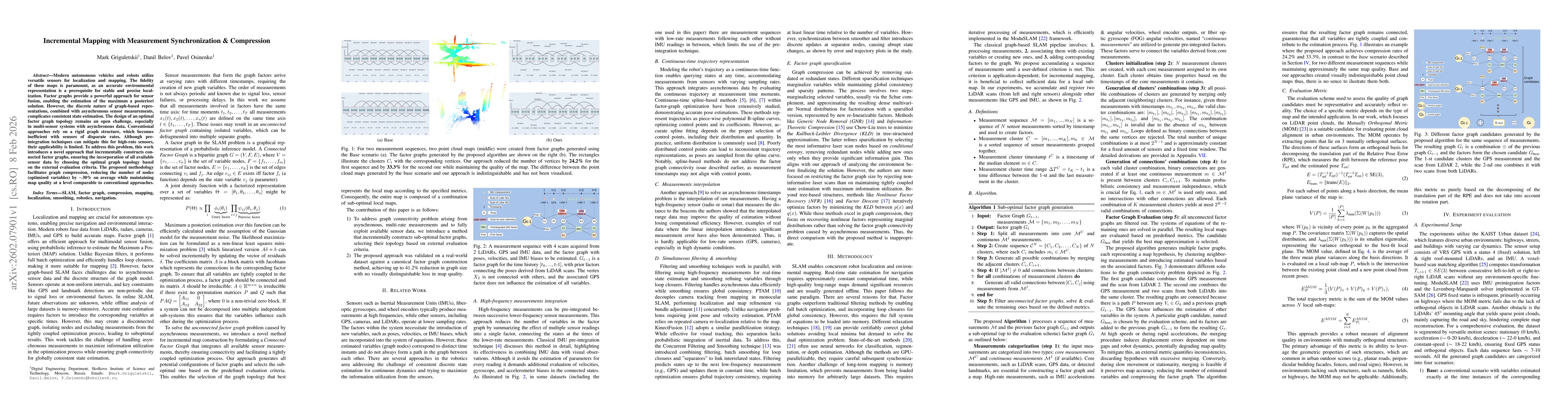
Modern autonomous vehicles and robots utilize versatile sensors for localization and mapping. The fidelity of these maps is paramount, as an accurate environmental representation is a prerequisite for stable and precise localization. Factor graphs provide a powerful approach for sensor fusion, enabling the estimation of the maximum a posteriori solution. However, the discrete nature of graph-based representations, combined with asynchronous sensor measurements, complicates consistent state estimation. The design of an optimal factor graph topology remains an open challenge, especially in multi-sensor systems with asynchronous data. Conventional approaches rely on a rigid graph structure, which becomes inefficient with sensors of disparate rates. Although preintegration techniques can mitigate this for high-rate sensors, their applicability is limited. To address this problem, this work introduces a novel approach that incrementally constructs connected factor graphs, ensuring the incorporation of all available sensor data by choosing the optimal graph topology based on the external evaluation criteria. The proposed methodology facilitates graph compression, reducing the number of nodes (optimized variables) by ~30% on average while maintaining map quality at a level comparable to conventional approaches.
AI Key Findings
Generated Feb 12, 2026
Methodology — What approach did the authors take?
Incrementally builds factor graphs by clustering adjacent core measurements, generating all valid cluster combinations, and selecting the best graph topology using a mutually orthogonal metric (MOM) to evaluate map quality.
Key Results — What are the main findings?
- Achieves ~30% reduction in factor graph size while preserving map quality.
- Maintains trajectory RMSE comparable to baseline across diverse urban scenarios.
- Demonstrates effective handling of asynchronous, periodic sensor data without loss of global consistency.
Significance — Why does this research matter?
Provides a scalable SLAM framework that efficiently fuses heterogeneous, asynchronous sensors, reducing memory and computation while ensuring accurate localization and mapping in real-world urban environments.
Technical Contribution — What is the technical contribution?
An algorithm for sub-optimal factor graph generation that clusters measurements, enumerates valid connections, and selects graph topology based on a geometric evaluation metric, enabling significant compression.
Novelty — What is new about this work?
First to dynamically adjust factor graph topology in real-time for asynchronous multi-sensor SLAM, achieving compression without sacrificing accuracy, and introducing a novel evaluation criterion based on mutually orthogonal surfaces.
Limitations — What are the limitations of this study?
- Performance degrades under high-speed dynamics where merging errors increase.
- Relies on GPS and LiDAR with orthogonal features; fails in feature-sparse environments like tunnels.
Future Work — What did the authors propose for future work?
- Develop learning-based strategies to predict optimal graph candidates and reduce computational complexity.
- Refine evaluation metrics to approach optimality and handle diverse environmental structures.
Paper Details
How to Cite This Paper
@article{belov2026incremental,
title = {Incremental Mapping with Measurement Synchronization & Compression},
author = {Belov, Danil and Griguletskii, Mark and Osinenko, Pavel},
year = {2026},
eprint = {2602.07901},
archivePrefix = {arXiv},
primaryClass = {cs.RO},
doi = {10.1109/ICAR65334.2025.11338676},
}
Belov, D., Griguletskii, M., & Osinenko, P. (2026). Incremental Mapping with Measurement Synchronization & Compression. arXiv. https://doi.org/10.1109/ICAR65334.2025.11338676
Belov, Danil, et al. "Incremental Mapping with Measurement Synchronization & Compression." arXiv, 2026, doi.org/10.1109/ICAR65334.2025.11338676.
PDF Preview
Similar Papers
Found 4 papersClass-Incremental Exemplar Compression for Class-Incremental Learning
Bernt Schiele, Qianru Sun, Zilin Luo et al.
Online Dynamic SLAM with Incremental Smoothing and Mapping
Jesse Morris, Yiduo Wang, Viorela Ila
Comments (0)