Infostop: Scalable stop-location detection in multi-user mobility data
Publication
Metrics
AI Quick Summary
The Infostop algorithm detects stop locations in multi-user mobility data more accurately than previous methods, allowing for better analysis of population movement patterns, including social meetings.
Paper Preview
Abstract
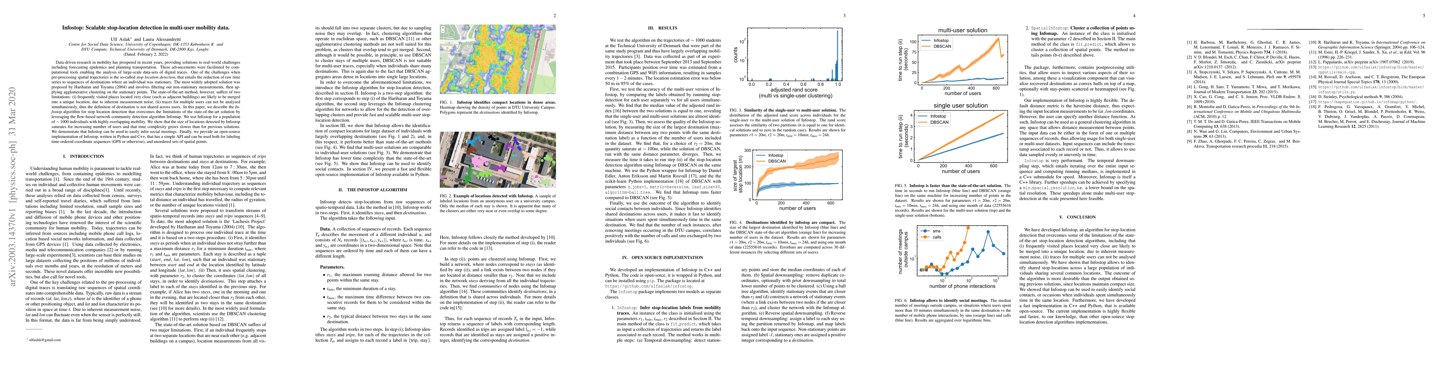
Data-driven research in mobility has prospered in recent years, providing solutions to real-world challenges including forecasting epidemics and planning transportation. These advancements were facilitated by computational tools enabling the analysis of large-scale data-sets of digital traces. One of the challenges when pre-processing spatial trajectories is the so-called stop location detection, that entails the reduction of raw time series to sequences of destinations where an individual was stationary. The most widely adopted solution to this problem was proposed by Hariharan and Toyama (2004) and involves filtering out non-stationary measurements, then applying agglomerative clustering on the stationary points. This state-of-the-art solution, however, suffers of two limitations: (i) frequently visited places located very close (such as adjacent buildings) are likely to be merged into a unique location, due to inherent measurement noise, (ii) traces for multiple users can not be analysed simultaneously, thus the definition of destination is not shared across users. In this paper, we describe the Infostop algorithm that overcomes the limitations of the state-of-the-art solution by leveraging the flow-based network community detection algorithm Infomap. We test Infostop for a population of $\sim 1000$ individuals with highly overlapping mobility. We show that the size of locations detected by Infostop saturates for increasing number of users and that time complexity grows slower than for previous solutions. We demonstrate that Infostop can be used to easily infer social meetings. Finally, we provide an open-source implementation of Infostop, written in Python and C++, that has a simple API and can be used both for labeling time-ordered coordinate sequences (GPS or otherwise), and unordered sets of spatial points.
AI Key Findings
Get AI-generated insights about this paper's methodology, results, significance, and more — seven facets brought into focus.
Impact
Paper Details
Authors
PDF Preview
Key Terms
Citation Network
Current paper (gray), citations (green), references (blue)
Display is limited for performance on very large graphs.
Discussion 0