Publication
Metrics
Quick Actions
AI Quick Summary
This paper proposes a LiDAR-based method for online intersection localization in autonomous vehicles, leveraging road segmentation and vehicle pose to detect and refine intersection points. The method is evaluated using an automated benchmarking pipeline, demonstrating superior accuracy and robustness compared to existing learning-based approaches.
Quick Answers
What methodology did the authors use?
The paper presents a LiDAR-based method for online vehicle-centric intersection localization that fuses semantic road segmentation with vehicle local pose to detect intersection candidates in a bird's eye view (BEV) representation, followed by refinement based on branch topology analysis. More in Methodology →
What are the key results?
The method outperforms the latest learning-based baseline in accuracy and reliability on the SemanticKITTI dataset. — Sensitivity tests demonstrate robustness to challenging segmentation error levels, highlighting its applicability in real-world scenarios. More in Key Results →
Why is this work significant?
This research is significant as it addresses the understudied problem of intersection localization, which is crucial for autonomous vehicle localization, mapping, and motion planning. The method leverages existing onboard semantic information and avoids the need for hand-labeled datasets. More in Significance →
What are the main limitations?
The method's performance may degrade in specific cases, as indicated by some performance reductions in certain sequences. — The method faces challenges with compound intersections, where multiple intersection points are clustered in a large common area. More in Limitations →
Abstract
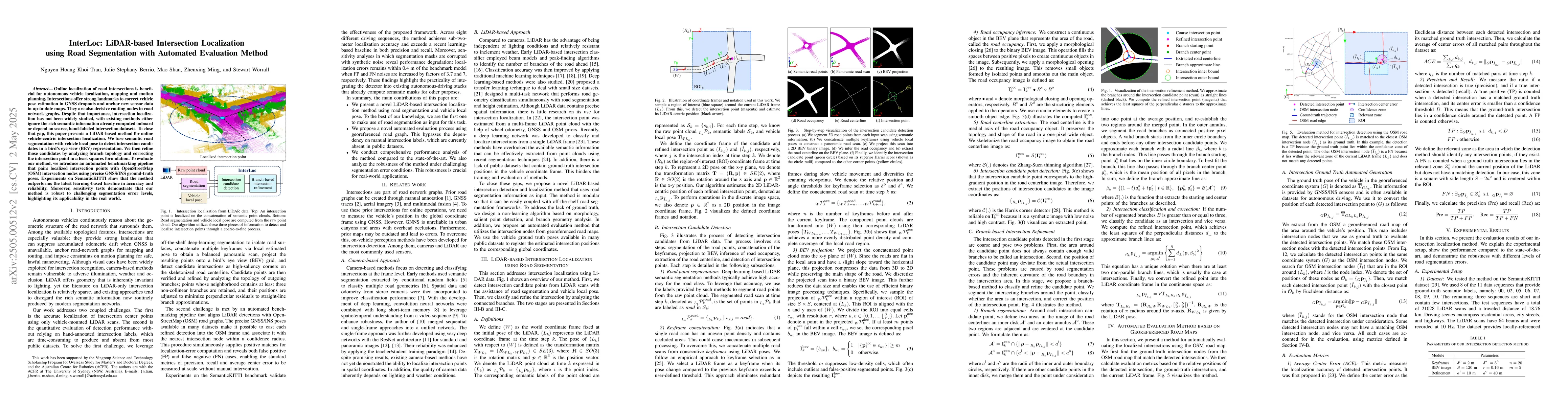
Online localization of road intersections is beneficial for autonomous vehicle localization, mapping and motion planning. Intersections offer strong landmarks to correct vehicle pose estimation in GNSS dropouts and anchor new sensor data in up-to-date maps. They are also decisive routing nodes in road network graphs. Despite that importance, intersection localization has not been widely studied, with existing methods either ignore the rich semantic information already computed onboard or depend on scarce, hand-labeled intersection datasets. To close that gap, this paper presents a LiDAR-based method for online vehicle-centric intersection localization. We fuse semantic road segmentation with vehicle local pose to detect intersection candidates in a bird's eye view (BEV) representation. We then refine those candidates by analyzing branch topology and correcting the intersection point in a least squares formulation. To evaluate our method, we introduce an automated benchmarking pipeline that pairs localized intersection points with OpenStreetMap (OSM) intersection nodes using precise GNSS/INS ground-truth poses. Experiments on SemanticKITTI show that the method outperforms the latest learning-based baseline in accuracy and reliability. Moreover, sensitivity tests demonstrate that our method is robust to challenging segmentation error levels, highlighting its applicability in the real world.
AI Key Findings
Generated May 28, 2025
Methodology — What approach did the authors take?
The paper presents a LiDAR-based method for online vehicle-centric intersection localization that fuses semantic road segmentation with vehicle local pose to detect intersection candidates in a bird's eye view (BEV) representation, followed by refinement based on branch topology analysis.
Key Results — What are the main findings?
- The method outperforms the latest learning-based baseline in accuracy and reliability on the SemanticKITTI dataset.
- Sensitivity tests demonstrate robustness to challenging segmentation error levels, highlighting its applicability in real-world scenarios.
- An automated benchmarking pipeline is introduced for evaluating intersection localization methods using OpenStreetMap (OSM) intersection nodes paired with precise GNSS/INS ground-truth poses.
Significance — Why does this research matter?
This research is significant as it addresses the understudied problem of intersection localization, which is crucial for autonomous vehicle localization, mapping, and motion planning. The method leverages existing onboard semantic information and avoids the need for hand-labeled datasets.
Technical Contribution — What is the technical contribution?
The main technical contribution is a novel LiDAR-based intersection localization method that uses vehicle local pose and semantic road segmentation to detect and refine intersection candidates in a BEV representation.
Novelty — What is new about this work?
The novelty of this work lies in its vehicle-centric approach that utilizes existing onboard semantic information and automated evaluation method, distinguishing it from existing methods that either ignore rich semantic information or rely on scarce, hand-labeled datasets.
Limitations — What are the limitations of this study?
- The method's performance may degrade in specific cases, as indicated by some performance reductions in certain sequences.
- The method faces challenges with compound intersections, where multiple intersection points are clustered in a large common area.
Future Work — What did the authors propose for future work?
- Further improvements can be made to handle compound intersections more effectively.
- Unifying the definition of the 'road' class across datasets could enhance the method's applicability and evaluation.
How to Cite This Paper
@article{berrio2025interloc,
title = {InterLoc: LiDAR-based Intersection Localization using Road Segmentation
with Automated Evaluation Method},
author = {Berrio, Julie Stephany and Shan, Mao and Tran, Nguyen Hoang Khoi and others},
year = {2025},
eprint = {2505.00512},
archivePrefix = {arXiv},
primaryClass = {cs.CV},
}
Berrio, J., Shan, M., Tran, N., Worrall, S., & Ming, Z. (2025). InterLoc: LiDAR-based Intersection Localization using Road Segmentation
with Automated Evaluation Method. arXiv. https://arxiv.org/abs/2505.00512
Berrio, Julie Stephany, et al. "InterLoc: LiDAR-based Intersection Localization using Road Segmentation
with Automated Evaluation Method." arXiv, 2025, arxiv.org/abs/2505.00512.
PDF Preview
Citation Network
Current paper (gray), citations (green), references (blue)
Display is limited for performance on very large graphs.
Similar Papers
Found 4 papersOff-Road LiDAR Intensity Based Semantic Segmentation
Kasi Viswanath, Peng Jiang, Sujit PB et al.
LiDAR-based HD Map Localization using Semantic Generalized ICP with Road Marking Detection
Yansong Gong, Xinglian Zhang, Jingyi Feng et al.
Boosting LiDAR-Based Localization with Semantic Insight: Camera Projection versus Direct LiDAR Segmentation
Sven Ochs, Philip Schörner, Marc René Zofka et al.
No citations found for this paper.
Comments (0)