Publication

Published: Sep 08, 2025
Categories: cs.CV, cs.RO

Metrics

Source: ArXiv

Quick Actions

View PDF

Quick Answers

What methodology did the authors use?

The research employs self-supervised learning strategies with location regularisation across CNN and ViT architectures. It uses georeferenced seafloor imagery datasets for training and evaluates performance through downstream classification tasks. More in Methodology →

What are the key results?

Location regularisation improved F1-scores by 4.9±4.0% for CNNs and 6.3±8.9% for ViTs — High-dimensional ViTs showed superior generalisation, achieving highest performance across all conditions More in Key Results →

Why is this work significant?

This work advances underwater robotics and marine monitoring by improving automated image interpretation. Enhanced self-supervised learning methods enable better analysis of large-scale seafloor data with reduced human intervention. More in Significance →

What are the main limitations?

ViT models require significantly more computational resources — High-dimensional latent spaces need larger datasets for downstream tasks More in Limitations →

Paper Preview

Abstract

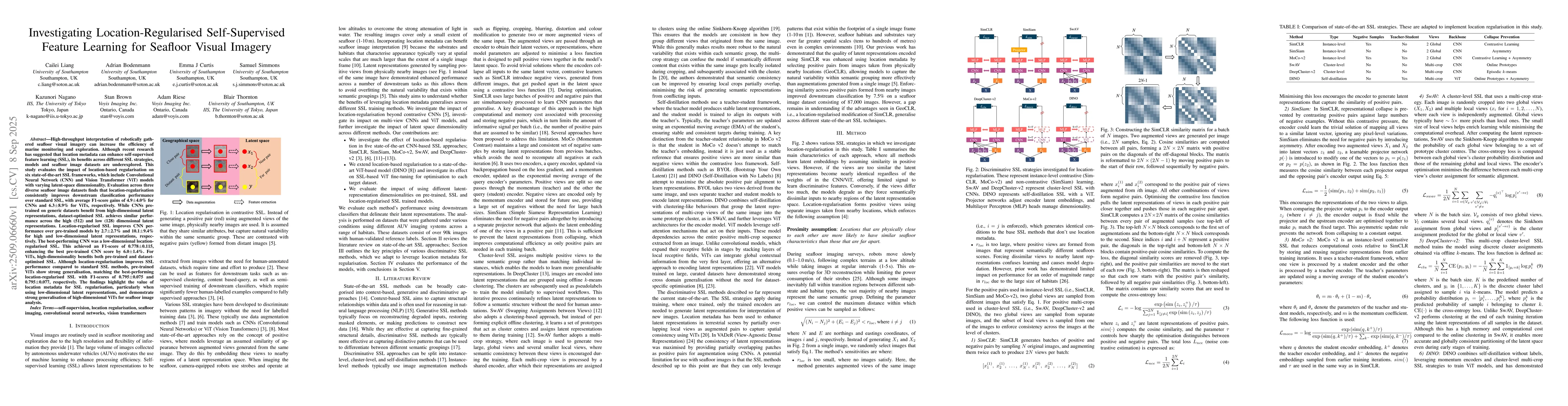
High-throughput interpretation of robotically gathered seafloor visual imagery can increase the efficiency of marine monitoring and exploration. Although recent research has suggested that location metadata can enhance self-supervised feature learning (SSL), its benefits across different SSL strategies, models and seafloor image datasets are underexplored. This study evaluates the impact of location-based regularisation on six state-of-the-art SSL frameworks, which include Convolutional Neural Network (CNN) and Vision Transformer (ViT) models with varying latent-space dimensionality. Evaluation across three diverse seafloor image datasets finds that location-regularisation consistently improves downstream classification performance over standard SSL, with average F1-score gains of $4.9 \pm 4.0%$ for CNNs and $6.3 \pm 8.9%$ for ViTs, respectively. While CNNs pretrained on generic datasets benefit from high-dimensional latent representations, dataset-optimised SSL achieves similar performance across the high (512) and low (128) dimensional latent representations. Location-regularised SSL improves CNN performance over pre-trained models by $2.7 \pm 2.7%$ and $10.1 \pm 9.4%$ for high and low-dimensional latent representations, respectively. For ViTs, high-dimensionality benefits both pre-trained and dataset-optimised SSL. Although location-regularisation improves SSL performance compared to standard SSL methods, pre-trained ViTs show strong generalisation, matching the best-performing location-regularised SSL with F1-scores of $0.795 \pm 0.075$ and $0.795 \pm 0.077$, respectively. The findings highlight the value of location metadata for SSL regularisation, particularly when using low-dimensional latent representations, and demonstrate strong generalisation of high-dimensional ViTs for seafloor image analysis.

AI Key Findings

Generated Nov 17, 2025

Methodology — What approach did the authors take?

The research employs self-supervised learning strategies with location regularisation across CNN and ViT architectures. It uses georeferenced seafloor imagery datasets for training and evaluates performance through downstream classification tasks.

Key Results — What are the main findings?

  • Location regularisation improved F1-scores by 4.9±4.0% for CNNs and 6.3±8.9% for ViTs
  • High-dimensional ViTs showed superior generalisation, achieving highest performance across all conditions
  • Low-dimensional CNNs matched or exceeded high-dimensional counterparts in performance

Significance — Why does this research matter?

This work advances underwater robotics and marine monitoring by improving automated image interpretation. Enhanced self-supervised learning methods enable better analysis of large-scale seafloor data with reduced human intervention.

Technical Contribution — What is the technical contribution?

Introduces location regularisation as a novel technique to enhance self-supervised learning in georeferenced visual data

Novelty — What is new about this work?

First comprehensive comparison of location regularisation effects across different architectures and dimensionalities in underwater vision tasks

Limitations — What are the limitations of this study?

  • ViT models require significantly more computational resources
  • High-dimensional latent spaces need larger datasets for downstream tasks

Future Work — What did the authors propose for future work?

  • Exploring hybrid architectures combining CNN and ViT strengths
  • Developing more efficient data augmentation techniques for underwater imagery
  • Investigating real-time deployment constraints for robotic systems

Paper Details

Paper ID: 2509.06660
Categories:
cs.CV cs.RO

How to Cite This Paper

BibTeX
@article{riese2025investigating,
  title         = {Investigating Location-Regularised Self-Supervised Feature Learning for
  Seafloor Visual Imagery},
  author        = {Riese, Adam and Bodenmann, Adrian and Thornton, Blair and others},
  year          = {2025},
  eprint        = {2509.06660},
  archivePrefix = {arXiv},
  primaryClass  = {cs.CV},
}
APA 7
Riese, A., Bodenmann, A., Thornton, B., Liang, C., Curtis, E., Nagano, K., Simmons, S., & Brown, S. (2025). Investigating Location-Regularised Self-Supervised Feature Learning for
  Seafloor Visual Imagery. arXiv. https://arxiv.org/abs/2509.06660
MLA 9
Riese, Adam, et al. "Investigating Location-Regularised Self-Supervised Feature Learning for
  Seafloor Visual Imagery." arXiv, 2025, arxiv.org/abs/2509.06660.

Comments (0)

This website uses cookies to ensure you get the best experience. Learn more